Monthly News Summary- August 2005
The Silver Symposium – CIMSS Turns 25
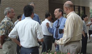 photo courtesy of Terri Gregory
|
|
The Cooperative Institute for Meteorological Satellite Studies celebrated its 25th anniversary in mid-July.
|
by Terri Gregory
The mood was congratulatory, appropriate for an institution that has survived and prospered for 25 years and also serves as a role model for other institutes like it. The Cooperative Institute for Meteorological Satellite Studies (CIMSS) celebrated its 25th anniversary in mid-July with a three-day symposium. This science symposium featured looks back and forward as well as appraisals of the present, both of CIMSS and satellite meteorology on the broader scale. A host of prominent invited speakers and a poster session addressed these issues as well, both from a national perspective and an international perspective.
Past CIMSS directors William L. Smith, Sr.; W. Paul Menzel; andDonald R. Johnson put past achievements in unique personal historical perspectives, while current director Steven Ackerman told how CIMSS is doing now. Moderator of the opening session John Roberts peppered his introductions with stories of each director, all the more vivid for his personal experience with them. Roberts is the Space Science and Engineering Center’s executive director for administration; SSEC is the CIMSS parent organization within the University of Wisconsin–Madison.
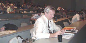 photo courtesy of Terri Gregory
|
|
Presenters like NASA Goddard’s Mike King discussed various achievements, collaborations, and information exchanges that fill CIMSS’s last 25 years. Many also mentioned ongoing projects and voiced hopes for the institute’s future.
|
In July 1980, UW–Madison and NOAAentered into an agreement to cooperate on research in satellite meteorology, founding the Cooperative Institute for Meteorological Satellite Studies within the Space Science and Engineering Center. Verner E. Suomi, acknowledged internationally as the father of weather satellites, had encouraged a group of federal researchers under the direction of Bill Smith to visit Madison and collaborate with researchers here. Arriving in 1977, it didn’t take long for the organizations and people involved to realize that the effort was producing good research and should be made permanent.
Fast forward to 2005 and a well-established organization continues to produce innovative and useful research. Most CIMSS research now becomes products that are used in routine weather forecasting by theNational Weather Service and other agencies around the world. Captain Caroline Bower, for example, of the Joint Typhoon Warning Center, explained how she uses techniques produced in CIMSS’s Tropical Cyclonesgroup in her typhoon forecasts.
Over the years, CIMSS has become a magnet for scientists around the world who want to enhance their research with satellite data or learn more about satellite meteorology in general. A lively, productive collaboration has ensued. Some of the researchers involved with CIMSS over the years talked about their research now and how it has been enhanced by their CIMSS involvement. Those include Johannes Schmetz of EUMETSAT, Europe’s agency that develops weather satellites and data. Schmetz told how EUMETSAT’s SSEC connection helped make possible water vapor data from METEOSAT (European geostationary weather satellite).
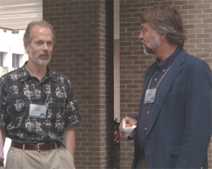 photo courtesy of Terri Gregory
|
|
CIMSS has become a magnet for scientists around the world who want to enhance their research with satellite data or learn more about satellite meteorology in general.
|
Throughout the U.S., governmental organizations, including cooperative institutes at universities, utilize weather satellite data in atmospheric studies and forecasts. Some of those who have worked closely with SSEC and CIMSS were represented in a “National” session.Thomas Vonder Haar, director of Colorado State University’s Cooperative Institute for Research in the Atmosphere, told the history of satellite meteorology since the 1980s and CIMSS’s role in it. Jason Dunion, who developed with Chris Velden the Saharan Air Layer theory of wind tracking, talked about that and other tropical cyclone products produced from satellite data. Dunion is now with the Hurricane Research Division in NOAA’s Atlantic Oceanographic and Meteorological Laboratory.
Five researchers with a strong background in satellite meteorology presented their hopes and ideas for the future in a panel discussion. Graeme Kelly,ECMWF, focused on instrumentation, including hyperspectral sounders, an area of expertise for CIMSS and SSEC. Scientists at this CIMSS symposium clearly believe the future of satellite meteorology lies in continuing to develop this area.
Slides and movies from presenters are available on the symposium Web site.Maria Vasys and others organized the symposium.
 |
|
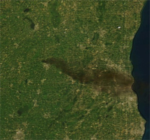
Its dark color gave the plume from the tire fire a distinct appearance. In satellite imagery, smoke plumes usually appear as a lighter gray. Click the image for a larger version.
|
Burned Rubber: When Tires Ignite—by Jennifer O’Leary
Although smoke from July 19tire fire near Watertown was visible from the roof of their home in the Atmospheric, Oceanic and Space Sciences building, researchers from the UW-Madison Space Science and Engineering Centertook advantage of satellite technology to look at the fire from space. These images graced the pages of newspapers as well as the airwaves to illustrate stories about the fire.
The fire broke out around 10 a.m. on July 19 at a tire recycling facility just outside of Watertown. The smoke created from close to a million burning tires reached heights of 5,000 – 6,000 feet.
On that Tuesday morning, Chris Schmidt (CIMSS) used a fire monitoring satellite tool, known as the Wildfire Automated Biomass Burning Algorithm, to quickly identify the plume. Schmidt also called on the services of the fabled “SSEC roof cam” (i.e. a digital camera) as he snapped some shots from atop of the building
Kathy Strabala (CIMSS) used SSEC’s direct broadcast facility to bring in data from NASA ’s MODerate Resolution Imaging Spectrometer, which gathers observations from 36 regions on the electromagnetic spectrum. TheSSEC Spotlight currently features one of these satellite images. TheWisconsin State Journal also used one to accompany an article that ran on July 23 with credit to UW-Madison.
At their request, Dave Stettner (CIMSS) and Scott Bachmeier (CIMSS) provided the local CBS affiliate with a satellite image. The station used the image as a lead into a tire fire story, their top story of that July 20 broadcast. They also featured the image with the online version of the story. The station credited CIMSS for the image.
 |
|
Two classic atmospheric science textbooks feature this figure prepared by Dave Tobin and Allen Huang.
|
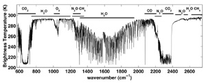
Textbook imagery—The second edition of Professors Wallace and Hobbs’ textbook,Atmospheric Sciences: An Introductory Survey, will include a figure prepared by Dave Tobin (CIMSS) andAllen Huang (CIMSS). The figure uses high spectral resolution observations made by the Scanning-HIS. Another classic textbook, K. N. Liou’s An Introduction to Atmospheric Radiation, also uses this figure.
Scaled down weather products—Russ Dengel (McIDAS Team) recently created a Web site with weather products modified for high-end PDA’s and Web phones. Dengel scaled the images down to accommodate smaller display screens.
User-friendly GOES—Following a recent request, Bill Bellon (SSEC) shifted some imagery on the GOES real-time Web page. Now, users will see GOES-East and a close-range image of Wisconsin followed by GOES-West.
Imager information—SSEC recently began to receive imagery from both Japan’s and China’s new geostationary weather satellite imagers. Initial calibrations indicate that the imagers are accurate. Further tests will add confidence to the data from these instruments, which will help SSEC make global observations.
 |
|
GOES-11 rapid-scan imagery now streams out of SSEC. This image isolates the area in Costa Rica where NASA Tropical Cloud Systems Processes mission is underway.
|
Data Center success—Through efforts of the SSEC Data Center,GOES-11 rapid-scan now streams out ofSSEC. This successful incorporation of imagery proved itself useful already as CIMSS researchers continue to providescience support for a NASA field experiment out of Costa Rica. From this experiment, the Tropical Cloud Systems and Processes mission, researchers hope to learn more about certain characteristics of tropical cyclones. According to Chris Velden (CIMSS), the rapid-scan feed has received “many positive comments from the scientific community.”
Post-launch calibration—In May 2005, a new Advanced Very High Resolution Radiometer (AVHRR) launched aboard NOAA-18. After the launch, Andy Heidinger (NOAA at SSEC) used new methods to calibrate the instrument. These methods involve MODIS data and show expected results for light and dark pixels in the reflectance channels. This calibration indicates the need for slight alterations to the pre-launch values set for channels one and two.
 |
|
This image shows the Western United States on July 28. The Biomass Burning Team uses the Wildfire Automated Biomass Burning Algorithm to generate fire data.
|
Monitoring fires around the globe—A team within theIntegrated Global Observing Strategy Partnership plans to update global observations to include specific fire monitoring components. Researchers withCIMSS’s Biomass Burning Team provided input regarding the use of geostationary weather satellites for non-weather purposes and hope to demonstrate the possibility of a global geostationary fire monitoring system by 2007. The Biomass Burning Team consists of Chris Schmidt (CIMSS), Joleen Feltz(CIMSS), and Elaine Prins (CIMSS).
SPIE 50th annual meeting—SSEC and CIMSS played a significant role in the 50th annual meeting of the International Society for Optical Engineering(SPIE). SSEC/CIMSS researchers participated in many aspects of the meeting. Allen Huang (CIMSS) acted as a conference chair, and Bormin Huang (CIMSS), Tim Schmit (NOAA at SSEC), Bill Smith, Jr. (LaRC) and Chris Velden (CIMSS) sat on the program committee. Hank Revercomb (SSEC) participated in the special panel, Three-Pillar Partnership in Remote Sensing: The Roles of Government, Industry and Academia. Jun Li (CIMSS) was a section chair for the GOES land applications session. On top of these roles, the conference featured many papers and posters from SSEC and CIMSS researchers.
|
photo courtesy of Tim Schmit |
|
CIMSS hosted the Cooperative Research Program Symposium on Calibration and Validation in mid-July.
|
Calibration and Validation Workshop—With the Advanced Satellite Products Branch (NOAA’s research group at SSEC), CIMSS hosted the Cooperative Research Program (CoRP) Symposium on Calibration and Validation in mid-July, with Jeff Key (ASPB at SSEC) and Maria Vasys (CIMSS) as organizers. The CoRP symposium is one of a series of meetings intended to survey current activities regarding calibration and validation (cal/val) of satellite instruments. According to organizers, this meeting series is also meant to
- foster interaction of students and young scientists
- educate students regarding satellite cal/val
- search for synergy between on-going activities at the cooperative institutes and NOAA
- discuss future plans for cal/val, including field experiments
Scientists, including graduate students, from CIMSS, the Cooperative Institute for Research in the Atmosphere (CIRA), the Cooperative Institute for Climate Studies (CICS), the Cooperative Institute for Oceanographic Satellite Studies (CIOSS), and the Cooperative Remote Sensing Science and Technology Center (CREST) attended. Al Powell, Acting Director of NOAA’s Office of Satellite Applications and Research that manages the cooperative institutes, told of NOAA’s commitment to them and explained the importance of the research collaboration of university and NOAA and noted that includes an emphasis on validation. Paul Menzel, a NOAA chief scientist based at SSEC, gave a thorough explanation of the essential parts of a Cal/Val program. Representatives of five cooperative institutes reviewed their programs. Most of the symposium was devoted to individual detailed elements of cal/val programs. PowerPoint presentations are posted on theWeb.
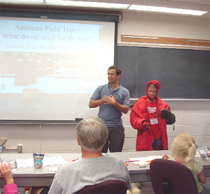
Antarctic weather meeting—Researchers who study Antarctic weather, or collect its data, met in June at the Byrd Polar Research Center in Columbus, Ohio. The meeting combines SSEC’s Automatic Weather Station program,Antarctic Meteorological Research Center, and the Antarctic Regional Interactions Meteorology Experiment (RIME), with those who use theAntarctic Mesoscale Prediction System (AMPS) and those who study icebergs. The meeting included birthday celebrations for AWS operations (25 years) and principal investigator Charles Stearns (80 years). Attendees included Italian and German researchers who have their own AWS networks. Agendas for all the meeting parts can be found on the AMRC meetings page. Abstracts and finished papers can be found on the individual pages.
Presentations and Publications
Arctic climate papers published—The July 15 edition of the Journal of Climate included a pair of papers co-authored by Xuanji Wang (CIMSS) and Jeff Key (NOAA at SSEC). In these papers, Wang and Key use satellite data to describe trends of surface, cloud, and radiation properties of the Arctic climate.
Paper published dealing with mineral dust—The Journal of the Meteorological Society of Japan recently published a paper about mineral dust. Jeff Key (NOAA at SSEC) co-authored this paper that discusses experiments conducted to gain insight into radiative forcing caused by mineral dust. Researchers from NOAA’s Advanced Satellite Products Branch and CIMSS helped develop the radiative transfer model used in these experiments.
On air with the Weather Guys—Weather Guys Steve Ackerman(CIMSS Director) and Jonathan Martin (AOS Chair), both professors in the Department of Atmospheric and Oceanic Sciences, made their monthly appearance on Larry Meiller’s WHA Radio call-in show on July 25. Jim Packard sat in for Larry Meiller and began with questions about water, of which Wisconsin has either had not much or too much in days preceding the broadcast. The Guys pointed out that fresh water is only .02 % of the total amount of water on Earth and it needs to be recycled constantly. They noted that rain received in mid-July will probably mitigate the effects of southern Wisconsin’s drought, but soil is still abnormally dry. Possibly thanks to the drought, Wisconsin’s tornado season is much less active than usual, and so far this year there have been no deaths associated with tornados.
In response to questions about hurricanes possibly affecting local weather, Martin thought it more likely that warm weather across the U.S. is conducive to hurricanes. The Guys noted that a large African dust storm is bringing dust to Florida and may inhibit hurricane activity for the next few weeks. Towards the show’s end, Jim asked questions that brought amusing responses. Jim: What’s the difference between Doppler and Super Doppler? Martin: An adjective. Jim: What do you look at first to know about the weather? Ackerman: The current satellite imagery, then the National Weather Service’s online weather discussion. That’s in the morning. Going home, I look at the radar.
For answers to all your questions about weather and climate, listen to The Weather Guys on WHA on the last Monday of every month. In or near Madison, listen on 970 AM or 90.7 FM. Or go to the Web at:www.wpr.org/webcasting/live.cfm.
Explaining space shuttle concerns—Evan Richards, SSEC aerospace engineer and quality control expert, appeared on WISC-TV, Madison’s CBS affiliate on July 27. Appearing on the late afternoon news program, Live at 5, Richards addressed safety and other concerns surrounding the Space Shuttle Discovery, which had been successfully launched that morning.
What Velden does— Chris Velden, leader of CIMSS’s Tropical Cyclones group, is featured in the premier appearance of “What I do,” a new column in the Wisconsin State Journal. The column, published in the paper’s Business section, will always feature people in unusual jobs. Velden and his group study and develop techniques to forecast the paths of hurricanes. Satellite data, received and archived at SSEC, make it possible, indeed, easy, to track hurricanes in Wisconsin.
Clever teaching tool—SSEC’s Office of Space Science Education has designed and constructed a kiosk to teach about the solar system. Sent toRockford’s Discovery World Museum, the interactive kiosk is the size of those seen in airports and, via a touch screen, provides information on Earth and all the other planets.
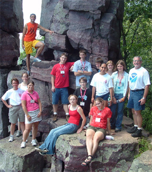 photo courtesy of Margaret Mooney
|
|
Participants in the SSEC’s Summer Workshop on Atmospheric, Earth, and Space Sciences take a field trip to Devil’s Lake accompanied by workshop organizer Margaret Mooney and Gary Wade.
|
High school students visit SSEC—TheSummer Workshop on Atmospheric, Earth, and Space Sciences for high school students was held for the thirteenth year this July 25–27 at SSEC. Eleven high school students participated in this year’s workshop that featured an exciting agenda in meteorology, astronomy, land remote sensing and geology.Margaret Mooney, this year’s organizer, told Madison’s TV Channel 27 that “UW–Madison is the best place to study meteorology, especially satellite meteorology.” Scientists come from around the world to study at SSEC’s Cooperative Institute for Meteorological Satellite Studies. Once a year, high school students have the chance to do the same.
Educating educators—CIMSS and SSEC’s Office of Space Science Education also give workshops to science educators, particularly high school and middle school teachers. In late June, Margaret Mooney and others gave a teacher workshop in satellite meteorology to 28 middle and high school science teachers who learned about weather satellites and SSEC’s contributions to satellite meteorology.
|
photo courtesy of Margaret Mooney and Terri Gregory |
|
Matthew Lazzara helps Grandparents’ U participants understand the finer points of Antarctic research.
|
Grandparents’ U—Grandparents’ U is a university-wideWisconsin Alumni Association summer event during which alumni and their grandchildren get a taste of a specific field of study. This year, a dozen sets of grandparents and children experienced a meteorology major withMargaret Mooneyand other experts. They built a state-of-the-art satellite (scale model), learned how satellites work and how NOAA uses their data, and got a tour of the roof of the AO&SS building.
Hard work awarded— NASA recently bestowed a couple of group awards upon SSEC researchers. The Advanced Satellite Aviation weather Products (ASAP) team won a group award. This team consists of: Wayne Feltz (CIMSS), Kris Bedka (CIMSS), and Michael Pavolonis(CIMSS). The Infusing satellite Data into Environmental Applications(IDEA) project also received an award. The awards booklet listed Scott Bachmeier (CIMSS), Pat Heck (CIMSS), Jerrold Robaidek (SSEC),Tony Wimmers (CIMSS), Bill Bellon (SSEC), Liam Gumley (CIMSS), and Kathy Strabala (CIMSS) for the IDEA project.
In the Journal—The Wisconsin State Journal recently ran a photo of CIMSS’s Jun Li watering his lawn. The photo accompanied an article about lawn care strategies in times of drought. Li is quoted in the article.
|
photo courtesy of Caluculated RISC’s blog |
|
Calculated RISC conferences near their vehicle “The Little Big-Endian that Could.”
|
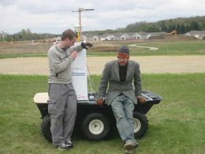
Up to the Challenge—by Jennifer O’Leary Each year the Defense Advanced Research Projects Agency (DARPA) accepts project ideas for a Grand Challenge. The challenge serves to catalyze the research and development of self-piloted ground vehicles. After an extensive application process, select teams try to complete a designated course through the desert in the Southwest United States in hopes of winning the $2 million prize. This year, Dave Parker (SSEC) entered a vehicle. A team consisting of Parker and a friend from Junior High, Calculated RISCcreated “The Little Big-Endian that Could.” Although the team did not make it into the top 40, they made it onto the alternate list. This list includes only ten teams. According to the team’s blog, “[t]here is a good chance that the top few teams from this next intermediate round will be invited to the [National Qualifying Event].” The National Qualifying Event is the fourth stage of the selection process and those that pass earn the right to compete in the Grand Challenge on October 8. Check out Calculated RISC’s blog to track their progress and understand that “innovation isn’t a product of funding or resume, but rather tenacity and imagination.”