Monthly News Summary – July 2002
Imagery Aids Fire Forecasters
by Terri Gregory, SSEC Public Information Coordinator
This material is not meant as comprehensive coverage of NOAA’s or other efforts to forecast or fight fires. It is meant to cover as much as possible of SSEC and CIMSS work related to current fires.Use images freely with credit to the Space Science and Engineering Center, University of Wisconsin–Madison. Other SSEC news for July is in another file.
Wildfires raged out of control in the western U.S. and Canada as NOAA prepared a new tool for routine use by forecasters. Secretary of Commerce Don Evans noted that, in Colorado, NOAA “dispatched specially-trained fire weather forecasters to work on the ground with the firefighters.” He listed tools available to the forecasters, including the Geostationary Operational Environmental Satellite (GOES) Wildfire Automated Biomass Burning Algorithm (WF-ABBA), “new satellite technology that relays real-time satellite imagery of the fires in progress.” Satellite images were provided every 30 minutes, he said, “to protect Colorado firefighters from changing winds and weather.” At SSEC, researchers responsible for the technique are Elaine Prins (NOAA, leads the project) and Chris Schmidt and Joleen Feltz (CIMSS). Throughout the duration of these intense fires, the WF-ABBA gave data in near real time and continues to do so, as long as the GOES operates. The WF-ABBA is expected to be “fully operational” for NOAA by the end of September. That means that by that time, documentation will have been supplied to the National Weather Service and all other requirements will have been fulfilled.
Federal Computer Week reporter Graeme Browning recently interviewed NOAA employees on high-tech support the agency is making available to National Weather Service and other forecasters and wild land fire agencies. Elaine Prins explained the history of the Automated Biomass Burning Algorithm (ABBA), from its first use in South America to track mainly agricultural burning to Canadian use in the 90s. Prins said, “The Wildfire ABBA was able to detect numerous fires in Quebec that were not detected using other conventional information.” After two years of experimental use for daily monitoring in the U.S., the WF-ABBA is now being used primarily to monitor rapidly growing fires, with fire products available every half hour over the Web. The WildFire ABBA is only one tool in the technology kit. Others are laptop computers, one-way satellite information, cell phones, satellite dishes and spot forecasts before a prescribed burn.
NOAA’s National Severe Storms Laboratory in Oklahoma made heaviest use of the GOES Wildfire ABBA during the Colorado wildfires. Prins said, “the fire information is integrated with other meteorological data for improved fire weather forecasting.” Bob Rabin, CIMSS visiting scientist employed by the NSSL, and CIMSS researchers provided the Storm Prediction Center with 24-hour composites. Fire weather forecasters said that they found the composite Wildfire ABBA fire products very useful as they compared the locations with their fire weather outlooks.
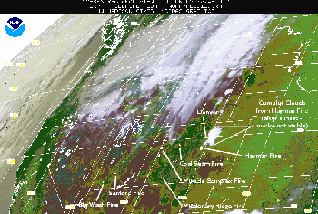 |
This GOES-8 Wildfire ABBA image composed at 0245 UTC on June 10 shows wildfires burning in Colorado and Utah. Color coding of the fire locators estimates sub-pixel fire size and temperature (red); saturated (yellow); or cloudy (magenta). Possible fire pixels indicate areas that may contain fire activity and should be closely monitored over time; high possibility fires are indicated in orange and low possibility fires are shown in blue. Click on image for full-size version. |
On Thursday, June 13, NOAA headquarters held a press briefing on drought and fire conditions in the western U.S. On Friday, June 14, the Department of Commerce released a media fact sheet explaining the GOES WildFire ABBA and other NOAA tools for fire forecasts. NOAA posted their release and one from SSEC. The Wildfire ABBA and transition to operations is also featured in the drought update withinNOAA News.
The Office of University Communications at the University of Wisconsin–Madison released the SSEC advisory on Monday, June 17 and published it in the Wisconsin Week Wire on June 26.
University Communications released the WF-ABBA news to AScribe wire service (June 17) and Newswise, an online service that “maintains a comprehensive database of news releases from top institutions engaged in scientific, medical, liberal arts and business research.”Several other online news services (USA Today, CBS News, and the Wall Street Journal) published articles containing material on the GOES satellite-derived fire products.
A piece by Meg Jones, Milwaukee Journal Sentinel technology reporter, ran in the Monday Health and Science section on June 17. On June 19 WMTV’s Courtney Monie’s piece ran in the evening news at 5, 6 and 10 p.m. They carefully showed the Web site, typing it large on the TV screen and spelling it out loud letter by letter. Joshua Wescott, WIBA Radio news director, interviewed researcher Chris Schmidt; different pieces ran periodically throughout the afternoon of June 19. One emphasized smoke effects on the Midwest. KSBK, Sacramento, CA, interviewed Elaine Prins, a California native, for coverage of their own wildfire.
Elaine Prins explained the use of satellites for monitoring fires on the Wisconsin portion of All Things Considered and Morning Edition on National Public Radio on June 19 and 20. She also was interviewed for Science Update, a radio feature of the American Association for the Advancement of Science (AAAS). The 90-second feature highlights interesting new research for a lay audience. A real-audio version will be posted on the Web by mid-July.
In Karen Rivedal’s piece in the Wisconsin State Journal, Prins explained use of the technique. “Fire-weather forecasters can look at these [satellite] pictures and see in real time if a fire is dying down or getting bigger. They can then integrate that with information on winds and humidity to help them make a better forecast.”
In an article by News Factor’s Brian McDonough, Prins noted that, “with 15 minute snapshots, it is possible to see where the fire is going, how fast it is getting there and how hot it is burning.” The Lincoln Journal Star, June 20, said that NOAA was giving firefighters “high resolution information of fire locations that cuts through the smoke and haze.”
The TV news service, Discoveries & Breakthroughs Inside Science, interviewed the group developing the algorithm. A crew from Madison-based WKOW TV asked the questions. The service syndicates its stories for The American Institute of Physics and its 10 member scientific societies. The story will be released on July 29.
Strategic Use Stressed
Erik Baard, Space.com, posted a technically oriented article on June 26. He noted some of the strengths of satellite data in forecasting the progress of fires. NOAA meteorologist Donna McNamara said, “Satellites work best for spotting fires starting in remote areas …” McNamara also noted that satellite data provides “a strategic view of the situation.” Strengths of the WF-ABBA also include its ability to evaluate fire characteristics. Baard noted that the WF-ABBA is also valuable in studying planetary climatology. To this end, Japan and Europe plan to include fire detection capabilities in their own satellites. The technique is only as good as the satellite it uses, and budgetary constraints mean compromise. CIMSS researcher Chris Schmidt noted, “Outfitting an operational environmental satellite with all the devices that everyone wants would be extremely expensive …”
MSNBC used Baard’s piece with images provided by NOAA. Linux Today used the piece; the algorithm runs on computers running Linux.
MODIS Provides a Detailed Perspective
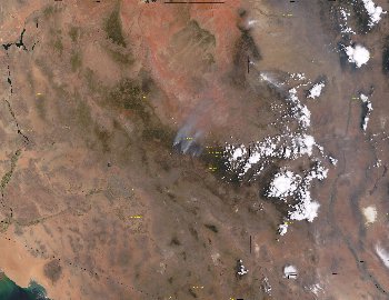 |
SSEC’s direct broadcast facility captured this MODIS image on June 28. It shows the Rodeo and Chediski fires in Arizona as they begin to merge. Click on image for full-size version. It is large and may take some time to load. (Liam Gumley) |
The MODIS (Moderate Resolution Imaging Spectroradiometer) instrument on NASA’s Terra earth observing satellite provided high resolution imagery when it passed over the fires once or twice a day. Terra is a polar-orbiting satellite in low earth orbit (about 435 miles or 700 kilometers above the earth), which encircles the earth about once every 90 minutes. The GOES stays in one place over the Earth, constantly taking observations of a whole hemisphere.
A new gallery of MODIS images is led by those showing fires. All these images are received directly at SSEC.
On June 21, CNN.com quoted the National Interagency Fire Center in Boise, Idaho: “Nineteen major blazes were burning across the nation Thursday [June 27],” twice the national average for this time of year. On July 2, National Public Radio reported that 19 fires were burning in 8 states. U.S. Air Force Captain and meteorologist Kurt Brueske thanked SSEC for MODIS imagery showing the fire near Hayman, Colorado . Brueske was supporting a cadet summer exercise at the Air Force Academy near the fire and gives a first hand account. “The cadets have found the MODIS images quite fascinating. I’ve pulled them down in the field via wireless connectivity … . The U.S. Air Force Academy is now on the southern-most edge of a standby evacuation region. … Our proximity to the fires has created some very unpleasant conditions, especially in the morning hours when our nocturnal winds veer around to the NNW which plugs us right into the fire smoke plume. Imagine dense fog, but instead of fog it is smoke. Needless to say it makes breathing difficult and irritates your eyes quite a bit. Conditions tend to improve during the day when our winds switch around to the S-SE and the smoke advects [blows] back towards the N. Earlier in the week, the SE containment area of the fire was breached which led to the destruction of 20-30,000+ more acres of land. One morning we had ash falling like snow. We’re expecting thunderstorms and about 0.25 inches of rain later this afternoon/evening. We had a cold front move through last night that produced some much needed rain and a relief in temperatures.” Finally, on July 3, it was reported that the Hayman fire was completely contained.
NASA’s Earth Observatory Web site used SSEC MODIS images of the Hayman fire and other western fires from June 10, 11, 20, 21, and 23. They used images of Canada’s fires on June 15 and 26, when lightning started 15 fires in a single day.
NASA’s Goddard Space Flight Center used a MODIS image on its Web site’s front page on June 25. As new images came available, Goddard used more. About 50 broadcast outlets used those images, including CBS Evening and Morning News and itsEarly Show, CNBC and CNN.
Liam Gumley is a manager of SSEC’s direct broadcast facility that brings in MODIS data and has been receiving and posting images of the fires to the Web and providing them to NASA. He was interviewed for the business section of dailycamera.com about his use of the Interactive Data Language, produced by Boulder-based Research Systems Inc. Gumley uses IDL to create MODIS images from any of the 36 channels.
Rodeo-Chediski Fires Evolve
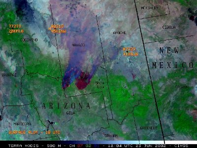
GOES Gallery—Scott Bachmeier (CIMSS) used SSEC MODIS data in this composite image to show fires in Arizona. Three of MODIS’ 36 channels are used in this composite image at 500-meter resolution. The image reveals two very large burn scars, with active fire hot spots around the edges, and thick smoke drifting northeastward. These two large fires (Rodeo and Chediski) exhibited extreme behavior due to high winds on June 23, 2002, and began to merge to the west of Show Low in southern Navajo county. The image also shows what would be possible from the Advanced Baseline Imager (ABI ), planned for a future geostationary satellite, with increased temporal resolution.
The rapid intensification of the Rodeo/Chediski complex on June 20, 2002 was one of the most extreme examples ever documented with the Geostationary Operational Environmental Satellite (GOES) Wildfire Automated Biomass Burning Algorithm (WF_ABBA) as shown in this animation by Chris Schmidt (CIMSS) and Elaine Prins (NOAA).
University of Wisconsin–Madison Communications Office released a tip featuring the fire imagery on June 27. The combined fire was said to be contained on July 5.
Fires Affect Wisconsin Skies
Recent fires in Arizona and Colorado have dominated the news, but fires in northwest Canada have populated the atmosphere with high concentrations of smoke particles. The smoke from Canadian fires was caught up in the atmospheric flow and blew into (advected over) Wisconsin, as shown by GOES and MODIS satellite images.
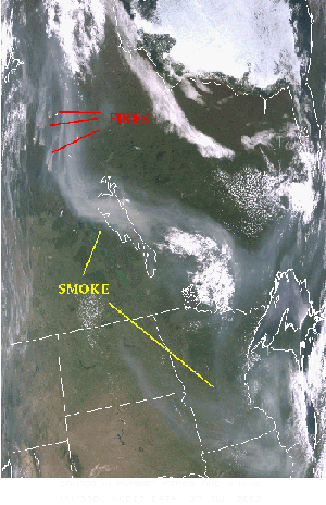 |
This MODIS image captured on June 27 shows the transport of smoke from Canada south into Wisconsin. Click on image for larger version. (Kathleen Strabala) |
On the afternoon of June 27, the smoke caused Madison’s sky to appear white, especially when looking towards the sun side of the sky, although all parts of the sky contained about the same concentration of smoke particles. This is a result of light interacting with the smoke particles, an effect known as scattering, where the direction of light is influenced by particles in the air. According to meteorologist Chris Moeller, in Mie scattering, an effect first described in 1908, sunlight is scattered preferentially in the forward direction. That is, a light particle entering the atmosphere and striking a smoke particle tends to continue forward. The scattering of all wavelengths (in this case, colors) of sunlight causes it to take on a white tone, unlike the pretty blue sky we’re used to seeing that results from atmospheric molecules scattering predominantly the blue light from the sun.
GOES ABBA Used in Navy Model
At the spring American Geophysical Union (AGU) meeting, NASA’s Earth Science news team issued a news release on the Fire Locating And Monitoring of Burning Emissions (FLAMBE) collaborative project that is funded primarily by NASA’s Earth System Science Enterprise Interdisciplinary Science program. FLAMBE integrates the original GOES ABBA algorithm into the Navy’s transport model to track smoke production. Partners in the collaboration are NASA, NOAA, and the Universities of Alabama and Wisconsin–Madison. The GOES WF-ABBA fire product is put into the Navy Aerosol Analysis and Prediction System.
NASA’s Earth Observing news team at Goddard Space Flight Center posted its release on the Earth Observing Web site on May 28, with images and information from the Wildfire ABBA Web site.
Lee Bowman covered FLAMBE for the Knoxville News and the Scripps Howard News Service on May 28, as did the Albuquerque Tribune, MSN News and Nando Times through United Press International.
Jeffrey Reid of the U.S. Navy’s Space and Naval Warfare Systems Center, San Diego, noted that “FLAMBE is one of the few projects to take real-time satellite data and put it into a real-time aerosol forecast model.” As noted in the release, NASA and NOAA have their own uses for the technique. Possible applications for fire observation are nearly limitless.
To define or explain some terms, I used the textbook, Meteorology—Understanding the Atmosphere, by Steven A. Ackerman and John A. Knox, © 2002, Thomson–Brooks/Cole.