Monthly News Summary – July 2001
Tornado Hits Wisconsin Town
by Terri Gregory, SSEC Public Information Coordinator
July 2001
This issue of In the News primarily covers May and June 2001. Please feel free to use images, with credit to the Space Science and Engineering Center, University of Wisconsin–Madison (SSEC/UW–Madison), except where otherwise noted.
A set of images taken by geostationary satellites stationed to observe both the east and west U.S. shows the development of severe thunderstorm activity that produced a deadly tornado that struck Siren, Wisconsin on June 18. A cloud-top signature called “enhanced-v” was evident in the GOES infrared imagery 15–30 minutes before the tornado’s development. Imagery from an overpass of the NOAA-15 polar orbiting satellite revealed even greater detail in the structure of the overshooting tops and cloud-top temperature patterns of the thunderstorm anvil region.
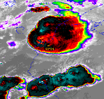 |
High-resolution satellite imagery reveals great detail in overshooting tops and cloud top temperature pattern (about 7 minutes before the tornado developed near Grantsburg, Wisconsin). |
Scott Bachmeier (in SSEC’s Cooperative Institute for Meteorological Satellite Studies) posted animations and images, including a Landsat image enhanced by UW–Madison’s Environmental Remote Sensing Center, on the CIMSS GOES Gallery. Polar-orbiting satellite images were featured on NASA’s Earth Observatory Web site.
Wisconsin Tornadoes—Listening to WHA’s Weather Guys Steven Ackerman (CIMSS and AOS) and Jonathan Martin (AOS) on June 25 was meteorology professor, John Knox, a former associate now teaching in Athens, GA. He added information to tornado references made during the WHA radio show. Siren’s tornado was an F3 in the Fujita tornado classification scheme. Other serious Wisconsin tornadoes, Knox said, were: the Barneveld tornado in 1984. It was an F5, as was the tornado that hit Oakfield, WI in July 1996. He noted two more past tornadoes:
- June 12, 1899—a tornado in New Richmond, WI, east-northeast of Minnesota’s Twin Cities killed 117 people, and was probably an F5. The tornado amazingly nailed a circus in town, hence the high casualty rate.
- May 10, 1953—an F4 tornado cut northeast across north and west Wisconsin from about Buffalo to Price counties. While it may not have killed anyone, technically, four people died during the outbreak, which was probably part of the same weather system that caused the famously devastating Waco, TX tornado the next day.
The tornado information comes partly from A Tornado Climatology for Wisconsin, by Pamela Knox and others, published by Wisconsin’s Geological and Natural History Survey and still available. Pam Knox, former Wisconsin State Climatologist, appeared frequently on WHA during the 1990s.
Splendid Developments
For More Information
Geocosmos—SSEC is contributing real-time worldwide weather imagery to a unique Japanese science museum. Geocosmos is a giant globe hung in a new Tokyo science and technology museum. Covered with thousands of LEDs, the globe can project any high-resolution image. Geocosmos developers have chosen to provide up-to-date weather information direct from SSEC’s Data Center via the Internet.
 |
This is a portion of the globe showing the LED arrangement and an SSEC-produced image of North America. |
The giant globe is a centerpiece in the National Museum of Emerging Science and Innovation, newly opened in Tokyo’s Aomi waterfront district. The museum is devoted to “sharing the most up-to-date information about science and technology” in an interactive environment. It promises to cover new fields as they emerge, such as nanotechnology and genome analysis and to show how they affect daily life.
Mars Scout mission—Sanjay Limaye is co-investigator on a newly chosen Mars concept study. MACO, or Mars Atmospheric Constellation Observatory, proposes a network of microsatellites around Mars to “characterize the 3-D structure of the atmosphere, giving a new look at Martian climatology.” It combines the talents of scientists from the University of Arizona, where the principal investigator, Robert Kursinski, is based, the Jet Propulsion Laboratory, and the University of Wisconsin–Madison, where Limaye is a planetary scientist. According to Space News, June 18, the ten innovative concepts chosen will help NASA “shape a broad competition that would pepper Mars with small missions in the future.” NASA will evaluate the concepts in six-month studies for possible new Mars Scout missions competing for a 2007 launch.
Weather Research
Numerical Weather Analysis—James Jung (CIMSS) and Robert Aune (NOAA, stationed at SSEC in the Advanced Satellite Products Team) continue to test GOES Sounder products in numerical models used by the National Weather Service. To accommodate the Cloud Top Pressure product in the Eta Data Assimilation System, the NWS forecast model, Jung uses a “nudging” approach to adjust the cloud field to generate a more realistic cloud and moisture field. To initialize clouds in the National Centers for Environmental Prediction’s Rapid Update Cycle model, an aviation forecasting tool, Aune uses cloud-top pressure and effective cloud amounts retrieved from GOES-8 and GOES-10 sounder data. The Forecast Systems Laboratory has shown that forecasts are improved by incorporating these data.
 |
Clicking on the image brings up an analysis of NOAA’s forecast model with and without cloud data from the GOES satellite. |
Satellite Data Applications—Tony Schreiner and Scott Bachmeier (CIMSS) and Tim Schmit (NOAA) developed a technique to identify snow during the day time. The procedure uses visible and shortwave infrared bands of the Geostationary Operational Environmental Satellite (GOES) Sounder. After incorporating the technique into the CIMSS current GOES sounder cloud mask, comparisons using last winter’s data showed improvement over the routine sounder cloud product.
 |
Click on the image for all four panels. |
Chris Velden and Dave Stettner (both of CIMSS) used the GOES 3.9 micron channel to derive nighttime low-level wind fields, preprocessing the images to enhance the warmer, low-level cloud features. Comparing the current automated tracking code using longwave infrared data for a month during this past winter with code modified to operate with shortwave data, Velden and Stettner found that coverage improved by about 50% with similar accuracy. Based on this initial demonstration, they will transfer the code modifications to NOAA’s Forecast Products Development Team for testing and transition into forecasting operations.
Satellite development—CIMSS scientists and NOAA counterparts in the Advanced Satellite Products Team are supporting design of the proposed next-generation geostationary sounding instrument, called the Advanced Baseline Sounder. Simulating the ABS high spectral resolution capabilities, Tim Schmit showed that its retrieval of thin cloud measurements are significantly improved over those of GOES-8. Jun Li and Tim Schmit showed that the retrieval of both temperature and moisture profiles are significantly improved with the high-spectral resolution data and that both profiles meet National Weather Service specifications.
For the planned NPOESS program, C. Justice (University of Maryland-College Park) asked Elaine Prins (NOAA) to provide input on the projected performance of VIIRS, the Visible and Infrared Imaging Radiometer Suite, a payload being prepared for the next generation of U.S. polar-orbiting satellites. Prins produced summary graphics outlining the impact of the VIIRS high resolution 11 micron channel (375 m) on sub-pixel fire characterization. She found that if the VIIRS saturation brightness temperature remains at the proposed 340 K, sub-pixel characterization of fire size and temperature estimates will be limited to only the smallest fires; most fires will saturate the 11 micron band. A saturation brightness temperature of 675 K is being requested of the instrument designers.
Fire Detection—Elaine Prins (NOAA) is working with R. Valdez of the National Zoo’s Amazon division to integrate GOES Biomass Burning Monitoring information into an online Geographic Information System (GIS) venue to be featured at the Zoo. Valdez also may highlight fires in the Amazon for a future GIS Day at the zoo. This would include a focus on how environmental satellites are used to detect fires in the region.
Florida Fires—The CIMSS GOES Gallery featured a very large smoke plume from fires burning in northern Florida on May 24-25. With their GOES-8 Wildfire Automated Biomass Burning Algorithm products, Chris Schmidt and Elaine Prins identified numerous fire pixels associated with these fires that burned approximately 20000 acres by the morning of May 25. Scott Bachmeier produced imagery and animations using GOES-8. An shortwave infrared image from the Moderate Resolution Imaging Spectroradiometer reveals a very large hot spot. MODIS and GOES data are received directly into SSEC.
Useful Data—Gail Bayler (CIMSS) and Gary Wade (NOAA) retrieved four months of archived GOES sounder products for C. O’Dell of the Observational Cosmology Group at UW–Madison’s Department of Physics. The data, total precipitable water and cloud parameters, are used to correct astronomical measurements taken at the Pine Bluff Observatory near Madison. O’Dell wrote, “We highly used the data set we got from you last year (March-May 2000); it was interesting to see our detector response increase (at 30 GHz) as the pwv’s [precipitable water vapor] went up.”
To increase understanding of relationships between microphysical and dynamical processes, Jeff Key provided satellite retrievals of cloud particle phase, particle effective radius, and optical depth derived from NOAA’s Advanced Very High Resolution Radiometer data to Dr. Ismail Gultepe of the Meteorological Service of Canada. Gultepe is comparing the satellite-derived microphysical cloud properties to those measured by aircraft during the Alliance Icing Research Study field project that took place over Ontario and Quebec regions of Canada during the winter of 1999–2000.
Field Experiment—To improve calibration of the Terra satellite instrument MODIS, Terra eXperiment 2001 took researchers and technical staff to San Antonio, TX in March. SSEC’s Scanning-High-resolution Interferometer Sounder and NASA’s MODIS Airborne Simulator (MAS) flew on the ER-2, a research aircraft that has played a major part in several SSEC-sponsored field experiments.
 |
This image from NASA’s Terra satellite was received from the MODIS instrument at SSEC’s direct broadcast facility on March 31 during the Terra Experiment 2001. |
Local TV stations interviewed pilots and crew and science team leader Chris Moeller. The San Antonio Express used the story in the following day’s paper.