SSEC High Spectral Work Aids U.S. Effort
Madison, WI, May 21, 2002—The NASA Aqua spacecraft launches the beginning of a new era in remote sensing that will vastly improve global and regional weather forecasting by providing accurate information on the state of the atmosphere. The Atmospheric Infrared Sounder (AIRS) on Aqua pushes its vertical profiling capability for water vapor and temperature to near the ultimate limit of passive systems (those that only receive radiation rather than emitting and receiving a return signal).
Researchers at the University of Wisconsin–Madison, Space Science and Engineering Center (UW–Madison, SSEC) have been advancing this approach for improved remote sensing for more than 20 years and are active members of the AIRS Science Team. They also develop instruments that will ensure that the basic AIRS capability continues in future US operational satellites. This complement of instruments will give weather prediction models better information than ever before available.
The Aqua satellite, the second major Earth Observing System platform, focuses on aspects of the earth’s hydrological cycle. (The first major platform, Terra, has provided detailed observations of the earth’s surface since 1999.) The AIRS instrument will measure radiation that the earth emits in 2,378 infrared channels (compared to about 20 in today’s sounders), resulting in highly accurate moisture and temperature from the surface to high altitudes, a true profile of the Earth’s atmosphere.
According to Paul Menzel, a NOAA chief scientist stationed at SSEC, AIRS is the “first high-spectral instrument that gives vertical resolution that numerical modelers have been waiting for in temperature and moisture definition.” Two microwave instruments onboard Aqua can see right through clouds and are key to achieving the full capability of AIRS wherever there are clouds-the Advanced Microwave Sensing Unit and the Humidity Sensor of Brazil. Another key instrument, the MODerate-resolution Imaging Spectroradiometer (MODIS) provides high spatial-resolution multi-channel imaging to better define cloud and surface properties, viewing features as small as 250 m or 1 km compared to 15 km for AIRS. The first MODIS is already providing an important new capability from its vantage point on Terra. Together the instruments provide a formidable suite of weather measurement tools.
Even before the launch of AIRS on Aqua, preparations were well underway to continue these types of observations with the next generation National Polar Orbiting Environmental Satellite System (NPOESS) and the Geostationary Operational Environmental Satellite (GOES) system. The confidence to proceed with such a commitment before any AIRS data has been collected is largely based on data collected by SSEC aircraft and ground-based instruments. To continue the global coverage provided by AIRS from a sun-synchronous polar orbit, the Cross-track Infrared Sounder (CrIS) is currently being readied for a 2006 launch. CrIS implements the basic design developed under an SSEC contract in the early 90s. The high-spectral resolution techniques represented by AIRS and CrIS are also key to observing from geostationary orbit, a location that allows rapidly developing systems and severe weather to be observed from a position fixed above the earth’s equator.
The geostationary analog of AIRS, the Geosynchronous Imaging Fourier Transform Spectrometer (GIFTS), is also on the verge of entering the implementation stage as a multi-agency (NASA, Navy, NOAA) mission, originated by the NASA New Millennium Program. The GIFTS instrument will provide a combination of AIRS-like sounding capability and rapid imaging from geostationary orbit. This combination of vertical profiling and imaging promises to offer a fundamentally new capability for providing accurate wind observations. The new IR observations will enable tracking of the motions of local pockets of water vapor in the atmosphere, giving wind measurements with unprecedented altitude accuracy.
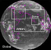
GIFTS can focus on local or regional areas on Earth to study, or even a whole hemisphere. (Image courtesy of NASA’s New Millenium Program)
GIFTS is a major event for SSEC researchers, because the instrument concept was developed by SSEC working in partnership with the Utah State University Space Dynamics Laboratory, and because SSEC will have a major role in GIFTS fabrication, testing, data analysis and validation.
Hank Revercomb, SSEC Director and AIRS Science Team member, called the confluence of two major remote-sensing events (the AIRS launch and the GIFTS program launch into implementation), a “major milestone in the advancement of remote sensing. It is difficult to accurately measure water vapor because of its subtle vertical structure, yet it is crucial to monitor because it fuels severe atmospheric events and it is of course vitally important for human life.”
Revercomb said that these are key steps in a progression to substantial improvement of global and severe weather observing capabilities. “If you care about wind and weather conditions that affect your daily activities, you should care about these improved measurements,” he said. He added that the data from these instruments will substantially add to our body of knowledge for climate change.
Revercomb is excited about using new data from instruments that SSEC has helped design. “Measurements from AIRS, CrIS and GIFTS will greatly augment the suite of products and capabilities SSEC has worked with NASA and NOAA to develop, starting with the spin-scan camera created by our SSEC founder and the ‘Father of satellite Meteorology,’ Verner Suomi, almost 40 years ago. Along with our development of instruments that measure the temperature from the ground and airplanes, these new instruments unify our efforts in remote sensing and modeling and make possible a greater diversity and depth in the NOAA products we generate, whether related to the temperature, water, clouds, surface properties, land or ocean.”
Revercomb stresses that SSEC is part of a community committed to the effort of continually improving measurements of the atmosphere. The AIRS instrument was designed and built by NASA’s Jet Propulsion Laboratory with input from scientists from several universities and government agencies.
The MODIS instruments are built by Santa Barbara Remote Sensing, a Raytheon division. Science team members from many different agencies are led by Michael King of Goddard Space Flight Center.
GIFTS is being developed by NASA, the U.S. Navy, the National Oceanic and Atmospheric Administration and Utah’s Space Dynamics Laboratory as well as SSEC with the leadership of NASA’s Langley Research Center, where William L. Smith, formerly of SSEC and NOAA, is Chief Scientist for Atmospheric Sciences.
SSEC also develops ground and aircraft-based instruments that profile the atmosphere using Michelson interferometers made by Bomem of Quebec, Canada. The suite of instruments includes the Atmospheric Emitted Radiance Interferometer, the High-resolution Interferometer Sounder, Scanning High-resolution Interferometer Sounder and, with NASA’s Langley Research Center, the NPOESS Atmospheric Sounder Testbed-Interferometer.
Contact: SSEC’s Public Information Officer, 608-263-3373