New Earth Science Data to Stream into UW’s SSEC–MODIS Antenna
On August 5, UW–Madison clears the last hurdle in the course of acquiring the next generation of global earth science data. On that day, a helicopter raises a new satellite tracking antenna to the top of the building that houses the Space Science and Engineering Center (SSEC). To protect it from the elements, the antenna will be covered by a 22 foot diameter radome. The helicopter will place the antenna-radome structure on top of a 40-foot tall tower that was air-lifted to the roof last November 27. In Madison, streets near the Atmospheric, Oceanic and Space Sciences Building will be closed, as they were the morning of November 27, to safeguard residents and passersby during the antenna lift. Rain date is August 6.
When NASA’s Terra satellite was launched on December 18 last year, scientists began to study the Earth in unprecedented detail with a suite of advanced scientific instruments. Among them is the Moderate Resolution Imaging Spectroradiometer (MODIS), a key instrument aboard Terra, which acquires images of the entire surface of the Earth every 2 days. MODIS monitors the Earth’s land, ocean and atmosphere in many different channels, or wavelengths, that look at light in very different ways. Researchers combine channels or view them separately to see many different properties that can be examined for trends in regional and global weather. SSEC researchers helped develop MODIS and the software that makes its data useful.
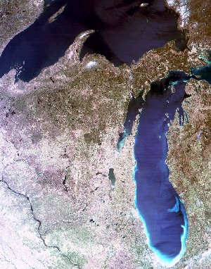
Acquired on April 24, 2000 at 1710 UTC (12:10 p.m. local time). This is a near true-color representation of the scene (Wisconsin, parts of surrounding states and Lakes Superior and Michigan), made by combining red, green, and blue image channels. Image resolution is 500 m per pixel.
SSEC’s Liam Gumley is program manager of the effort to create scientific products from MODIS data. He said that SSEC’s new antenna will receive data when Terra is flying over the continental U.S. “Unlike the large dishes on top of the roof which receive global data from geostationary GOES satellites (they remain at the same equatorial location in our sky), the Terra satellite orbits the earth from pole to pole at 705 km [about 438 mi] altitude making it possible to cover the whole U.S. and much of central Canada from our Madison location. This antenna gives SSEC and UW–Madison the ability to receive this high-quality data in real-time as it is seen by MODIS on the spacecraft. The launch of Terra’s sister spacecraft Aqua in December this year will double the amount of information flowing through the antenna into SSEC. In addition, through our partnership with NASA, our researchers also have access to the global MODIS data sets within a few days.”
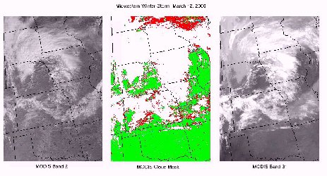
This set of images shows a typical Midwestern winter storm with an area of snow from a previous storm running SW to NE. Because of high spatial resolution and the many spectral channels of MODIS, we can more easily discriminate between clouds and snow on the ground. The cloud mask, an SSEC science data product, makes it possible for scientists to accurately discriminate between snow (white) and cloud (also white in Band 2, but whiter in Band 31). The cloud mask combines information from both bands. In the middle image, all that is white is cloud, whether snow covered or not.
SSEC researcher Christopher Moeller is pleased with the new capabilities open to him. “New information on cloud, atmospheric water vapor and aerosol distribution, land and ocean surface characteristics, and biological activity will be available in real time. Now we can evaluate the evolution and interaction of these complex Earth processes. This monitoring will lead to an improved understanding of the earth as a system, rather than as a series of seemingly isolated events.”
Paul Menzel, a NOAA chief scientist stationed at UW–Madison, is organizing international users of the MODIS data. SSEC is developing and distributing a software package to research institutions around the world to help the global science community efficiently use the data. Menzel said, “The MODIS is providing measurements in more visible and infrared channels than ever before. Old measurements are being continued and new ones are being introduced. MODIS is making these measurements with better resolution and higher quality than prior sensors. The new capabilities of MODIS offer exciting science opportunities for monitoring and understanding the interactions between land, ocean and atmosphere.”
Shortly after the antenna is raised on August 5, MODIS data will stream into the Space Science and Engineering Center where researchers will monitor existing MODIS science products like cloud cover and investigate MODIS data for new signatures of global change. One of the ways they will do this is by combining MODIS measurements with those of the Geostationary Operational Environmental Satellite (GOES). SSEC already is the national archive for NOAA for GOES information. Data from MODIS will greatly expand and enhance SSEC’s archive, made available to scientists throughout the world. SSEC is one of four U.S installations to receive MODIS data.
Watch NASA’s Web page for images from the Terra satellite. Scientific data products will be made routinely available through the SSEC antenna by early September.
For more information contact: SSEC’s Public Information Officer or at 608-263-3373.