Interferometry Enables Detailed Atmospheric Measurements
by Terri Gregory, SSEC Public Information Coordinator
The third in a series of Convection And Moisture EXperiments, sponsored by NASA, studies hurricanes and the conditions that create them. CAMEX-3 takes place August 6 through September 23 in the Caribbean and Atlantic Ocean where many hurricanes occur, based in Florida’s U.S. Air Force bases and Andros Island in the Bahamas. Several organizations are sending scientific instruments to fly on NASA aircraft, primarily the DC-8 and the high-altitude ER-2. Check out the CAMEX-3 Web site for more information on the experiment itself.
POWERFUL TOOLS GIVE DETAILED PROFILES
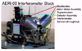
Among the instrument suites in CAMEX-3 are some from the University of Wisconsin-Madison’s Space Science and Engineering Center. The High-resolution Interferometer Sounder and its ground-based cousin, the Atmospheric Emitted Radiance Interferometer, are powerful tools for meteorological analysis with an ability to profile the atmosphere in an extremely detailed manner.
Both of these scientific instruments are spectrometers, meaning they analyze streams of light, in this case infrared, which our eyes cannot see, but which shows temperature. The developers of HIS, the new Scanning-HIS and the AERI use the advanced light-splitting capabilities of interferometry to analyze in great detail the infrared radiance emitted by the atmosphere. From the resulting spectra, very detailed profiles of water vapor and temperature are produced.
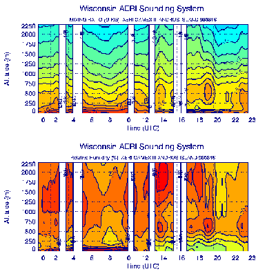
The Atmospheric Emitted Radiation Interferometer took the measurements that were used to create these cross sections of the atmosphere. The image of mixing ratio (top) shows the grams of water vapor per kilogram of air. A mixing ratio of more than 20 shows wet air; very wet air is close to the surface on this day, August 16, 1998.
Relative humidity (bottom) shows saturation, or cloud formation. 100% is a cloud. Spaces in both images show cloud blocking the instrument’s view through the atmosphere.
AERI is the ground-based version of the HIS which was designed first and flies on high-altitude aircraft. During CAMEX-3, a new instrument, the Scanning HIS, is flying on a DC-8 airplane. From a position in space or on the ground, the instruments make very fine measurements of the air or water under or over them. The Scanning HIS makes very fast measurements at several angles, not just straight down. The measurements can easily be pieced together to cover a wide area. The ability of both instruments to measure minute variations in temperature and water vapor in and around developing tropical storms will be helpful in this hurricane experiment, especially when the measurements are compared with those of other instruments being used. Besides water vapor and temperature, the AERI and S-HIS are collecting information on clouds, water and land emitted radiation, aerosols, and trace gases. By combining data from AERI and HIS with all the other instruments involved in CAMEX, scientists hope to gain a complete detailed picture of the conditions in which storms develop with a hope of understanding hurricane mechanisms.
The SSEC instruments use modified Michelson interferometers manufactured by BOMEM of Quebec, with two to four detectors for different wavelength coverage, a scene imaging scan mirror, and a two point calibration system. A spectrum at one wavenumber resolution is produced from 3-20 µm with an absolute accuracy of better than 1%. HIS and AERI have been in development since 1986, and have taken useful data in many weather experiments. The new Scanning-HIS was designed to fly on unmanned aircraft and is extremely small and light-weight. The Scanning HIS takes a spectrum every second, containing up to about 10,000 data points.. The AERI takes a spectrum about every ten minutes from the ground, and is used continuously in the U.S. Department of Energy’s Atmospheric Radiation Measurement program for the study of global change.
For general information and to contact authors, contact Terri Gregory, (608) 263-3373.