My Current Research Themes
The examples below aim to illustrate how I examine global and regional implications of clouds and precipitation. My work is steered by the use satellite observations coupled with numerical weather prediction models. Through this integrative approach, my research examines the effects and ramifications of clouds at the global scale as well as within distinct regional contexts.
Leveraging satellite data to examine how various cloud types impact Earth's radiative balance
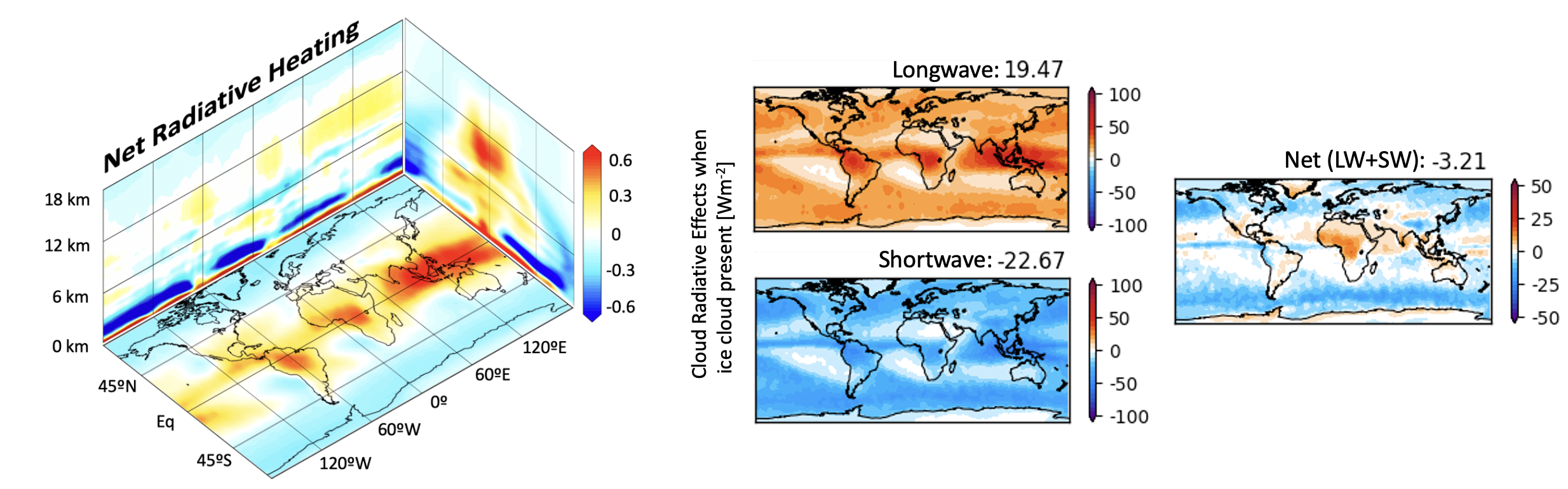
The Earth's climate system is driven by a balance between incoming solar radiation (known as shortwave radiation; SW) and outgoing thermal radiation (referred to as longwave radiation; LW). Clouds play a pivotal role in modulating both SW and LW radiative fluxes.
They reflect solar radiation and absorb as well as emit thermal radiation, resulting in what are termed as SW and LW cloud radiative effects (CREs). Understanding the influence of specific cloud types on global radiation variability is crucial to comprehending
their respective impacts on climate trends and alterations in the global circulation.
Ice clouds, encompassing cirrus clouds, along with other high-altitude clouds such as altostratus and deep convective clouds, significantly contribute to global CREs, particularly high-altitude ice clouds that blanket substantial areas in the tropics.
This ongoing research uses active spaceborne satellite sensors to identify the clouds responsible for driving shifts in Earth’s radiative balance. It examines the significance of various ice clouds on cloud radiative effects and how fluctuations in
ice cloud properties bring about alterations in the net radiative balance.
Using NASA satellite data to connect atmospheric energetics to our global circulation

Investigation into the relationship among clouds, precipitation, and the environment is crucial for comprehending the complex dynamics within Earth’s atmospheric circulation. Despite a considerable body of work exploring the relationship between clouds and
our planet's large-scale circulation, our current grasp of how different types of clouds and precipitation govern circulation responses remains incomplete.
This research focuses on examining the seasonal and interannual variations in both latent and radiative heating, utilizing vertically-resolved satellite data gathered from NASA satellite missions. The resultant satellite-derived
data forms the foundation for establishing an integrated observation-model framework. This framework enables the dissection of cloud impacts within both the Madden-Julian Oscillation (MJO) and the global circulation, achieved
through the utilization of a global model. This investigation aims to better understand the intricate balance between radiative and latent heating sources in steering global teleconnection patterns between tropical and extratropical regions.
Understanding convective initiation processes through satellites and models
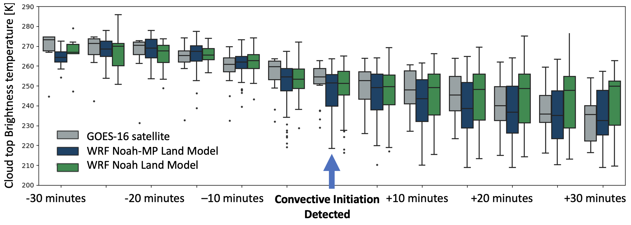
Numerical Weather prediction (NWP) models rely on numerous parameters and assumptions. This research looks to aid how land surface properties directly influence local circulations, crucial in the genesis of cumulus clouds and thunderstorms.
To aid in improving severe weather forecasts, we investigate how variations in the land surface energy balance affect the development of cumulus clouds and thunderstorms
across the southeastern United States.
By tracking cloud growth over time, we compare the simulated model cloud growth characteristics to observations from geostationary satellites. This comparison is possible by utilizing a radiative transfer model to simulate cloud top
characteristics from the model similar to geostationary satellite data (image above). Our work has demonstrated that cloud growth is remarkably sensitive to the model's interpretation of the surface energy balance – heavily influencing the mechanisms steering
the formation and longevity of thunderstorms. Our goal is to combine NWP data, geostationary satellites, and ground validation data to track the differences in cloud growth in cumulus clouds growing towards convective initiation
(high probability of a thunderstorm) compared to those that do not.