Image 1: The Globe Display
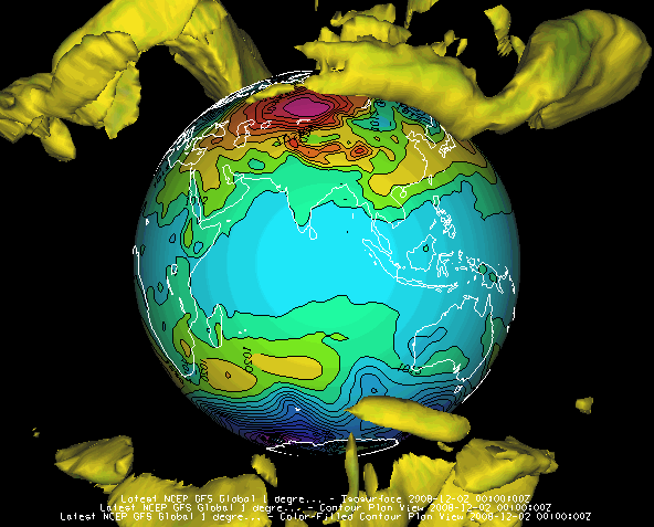
The illustration shows a McIDAS-V globe display of the earth, with AVN numerical weather prediction model output of mean sea level pressure (as color-shaded image and contour lines) and 50 m/s wind speed isosurfaces showing the jet streams. The upper vertical scale is set to 32,000.
For more about this display and how to make it, see Using the Globe Display.
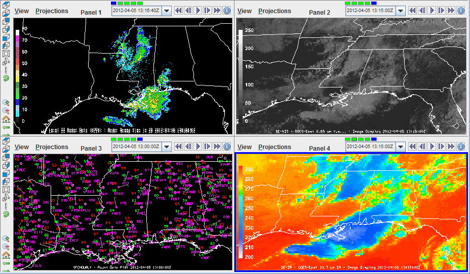
You can create multi-panel map and globe displays through the File->New Display Tab (Window)->Map (Globe) Display-># panel(s) menu. Below is an example of a four panel display of storms over Mississippi and the Gulf of Mexico. The first panel is radar reflectivity from central and southern Mississippi. Panel two is a Goes East visible satellite image. Panel three contains point data metars over the Gulf coast region. Panel four is a Goes East IR satellite image, with an enhancement for temperature.
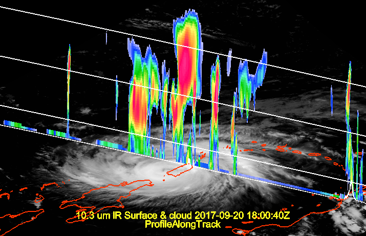
The ProfileAlongTrack display plots CALIPSO, CloudSat, and HSRL2 lidar data. See ProfileAlongTrack Controls for more information on this display. The image below shows CloudSat radar reflectivity (vertical curtain) displayed using the ProfileAlongTrack display type overlaid on a GOES-16 ABI image.
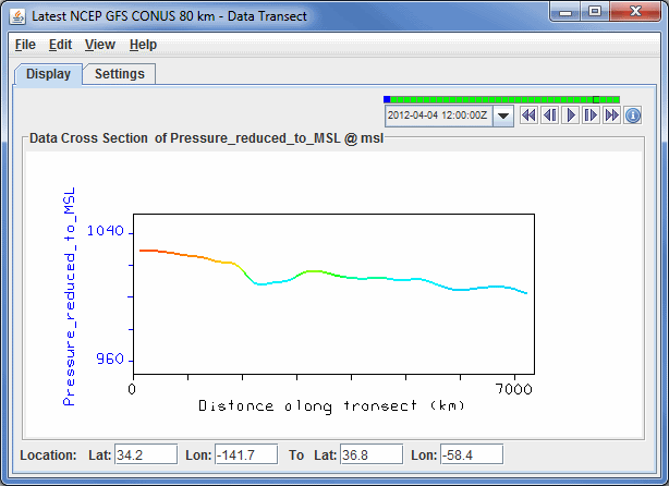
The Data Transect display plots in the Layer Controls tab of the Data Explorer, and plots a line of data at a constant height. The X-axis of the plot represents distance, and the Y-axis represents the numerical value of the parameter you are plotting. In the Main Display window, you can drag the end points of the transect line, to move the transect to your desired location. See Data Transect Controls for more information on this display.
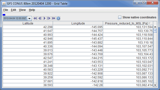
The Grid Table display plots in the Layer Controls tab of the Data Explorer, and plots a chart of the numerical value of the field you are displaying at individual latitudes, longitudes, and altitudes (if available). See Grid Table Controls for more information on this display.
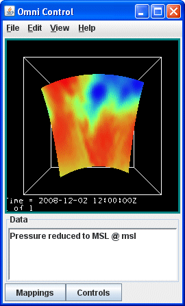
The Omni display is a VisAD Spread Sheet, loaded with the parameter selected and its coordinates and units. The Spread Sheet is used to create a display where you have complete control over which coordinates are the axes, how it is colored, and so on. See more in the Omni Control.
For use of the Spread Sheet, see the VisAD Spread Sheet document at https://www.ssec.wisc.edu/~curtis/ss.html.
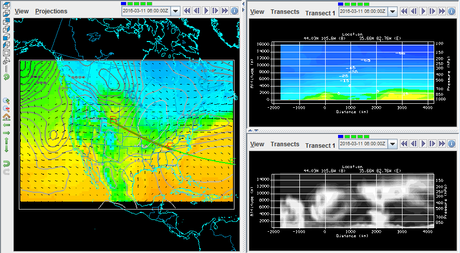
The Main Display window allows for various configurations of maps and transects. Through the Main Display window, use the File->New Display Tab (Window)->Transect Display-># panel(s) to create a tab that contains anywhere from one to four transects. Additionally, as shown below, there are a few panel configurations that allow for having maps and transects in the same display. These configurations can be found under File->New Display Tab (Window)->Misc, where there are options for one map and one transect, one map and two transects, as well as two maps and one transect.
For more on using the transect panel type, see Transect Views.
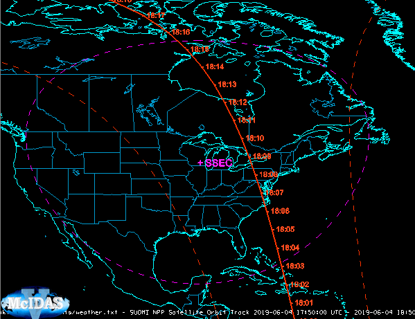
TLE data sources loaded through the Satellite->Orbit Tracks chooser are displayed with the Satellite Orbit Track display type. Customizable aspects of the display include setting the track/swath line width, color, and style. The user can also add ground stations to the display which are customizable as well. In the image below, Suomi NPP tracks are plotted and a ground station for SSEC (Space Science and Engineering Center, Madison, WI) is drawn.
For more on using the Satellite Orbit Track display, see Satellite Orbit Track Controls.