The 2013 Hazardous Weather Testbed: SSEC/CIMSS Scientists Demonstrate Satellite Products to Forecasters
Each year forecasters strive to detect severe weather earlier so that timely warnings can be issued. Every extra minute is critical; the sooner the warnings come, the sooner the public can take action, translating into more lives saved and potentially less property damage. Determined to make this difference, forecasters are eager for new tools and the training to use them. At the same time SSEC/CIMSS scientists have been researching new methods of severe weather detection using satellite data. For three weeks this month, six SSEC/CIMSS scientists will travel to Norman, OK to participate in the 2013 Hazardous Weather Testbed (HWT) to share their research with forecasters, who learn to use the products and provide feedback to the developers on their effectiveness.
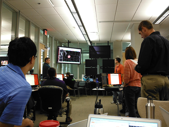
Forecasters and researchers at a briefing during Week 2 of the HWT. (Photo credit: Amanda Terborg, SSEC/CIMSS)
The HWT brings researchers and forecasters together to evaluate tools that will allow the forecasters to create better forecasts and timely warnings. CIMSS researchers have been participating in the HWT since 2009 with a focus on developing and sharing products that will improve the lead times for warnings.
According to Chad Gravelle, SSEC/CIMSS Satellite Liaison for the National Weather Service, “One of the goals is to try and issue these warnings a little sooner than with legacy products… to try to incorporate new products and see how they fall in the warning process. Does the tool allow you to do that [issue warnings sooner]? Do you have enough confidence with these tools?”
CIMSS researchers are also preparing forecasters for the types of products that will be available from GOES-R, the next generation geostationary weather satellite set to be launched in 2015. The products that CIMSS scientists are demonstrating this year include:
- Cloud and moisture imagery which are simulations of the imagery that will be available from GOES-R;
- Cloud Top Cooling (CTC) rate, which Gravelle described as “a quantitative estimate of how fast convective clouds are growing” which helps indicate whether a storm is beginning to develop, what is known as convective initiation; and
- NearCasting model, a short-term (0-6 hour) forecast of moisture and instability, developed by SSEC’s Ralph Petersen.
Working in teams of two, the HWT forecasters practice using these (and other) tools and techniques to issue warnings for severe weather. While the forecasters are looking at live weather around the United States, the warnings they issue do not leave the HWT, creating a safe and yet realistic situation for training and evaluation purposes, noted Gravelle.
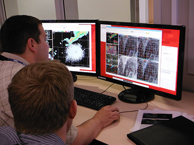
Chris Leonardi (Weather Forecast Office, Charleston, WV) looking at the CTC and convective initiation data. (Photo credit: Amanda Terborg, SSEC/CIMSS)
At the end of each day, forecasters complete surveys and discuss with each other what they learned and experienced as they attempted to put their knowledge into practice. All the feedback will be compiled into a final report at the conclusion of the HWT to allow developers to explore how they can improve their products and make them more useful to forecasters.
The feedback the forecasters provide on each product is invaluable. Amanda Terborg, SSEC/CIMSS Satellite Liaison for the Aviation Weather Center, credits the amount of time forecasters spend preparing themselves even before they arrive at the HWT. “The training that they go through, the WES [Weather Event Simulator] cases that they go through, are very good. When they come here, they already know what they’re doing with the products. So they are able to give some very good feedback.”
Gravelle commented on how the CTC has evolved as a result of HWT feedback. Early on forecasters noticed that any upper-level cloud cover caused problems for the CTC’s effectiveness. Consequently, CIMSS researchers made adjustments so that the product not only handles thin clouds above the developing convection, but now also works at night.
Of the three CIMSS products being evaluated this year, Gravelle noted that forecasters seem particularly interested in learning more about the CTC. “It’s a tool that they’re not familiar with … this Cloud Top Cooling product fills a void between a short-term model forecast and actual observations of convection.”
To show what the forecasters are working on and evaluating during the HWT, a blog has been created to highlight sample cases. For example, on 9 May SSEC/CIMSS researcher Lee Cronce wrote a post noting the CTC’s success in detecting the potential for severe convection near Amarillo, TX. Initially noted with the help of satellite data at 2045 UTC, the developing storm later turned more severe, producing hail (first reported at 2251 UTC).
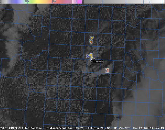
CTC at 2045 UTC on 9 May 2013 near Amarillo, TX.
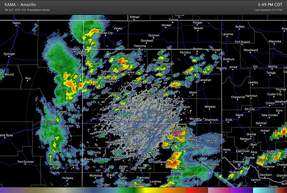
Reflectivity from the Amarillo, TX radar at 2249 UTC, around the time of the first report of hail, showing the now developed storm.
In addition to Gravelle, Terborg, and Cronce, SSEC/CIMSS scientists Wayne Feltz and Jason Otkin, along with graduate student Jordan Gerth, will travel to Norman, OK to interact with forecasters at the HWT. With each demonstration they have the opportunity to share products that they hope will in time become operational, adopted by the National Weather Service making them available to all forecast offices on a regular basis.
For more information about the HWT:
GOES-R Proving Ground HWT blog
NOAA HWT Web site
by Leanne Avila