Monthly News Summary – September 2008
Forecasting Tropical Cyclones in the Western Pacific
Forecasting Tropical Cyclones in the Atlantic Ocean is difficult enough, but doing it in the Western Pacific is even harder. Without the benefit of the aircraft reconnaissance routinely flown in the Atlantic, satellite observations are even more indispensible over the expanses of the Pacific Ocean.
To understand this vast region better, PI Chris Velden and members of the CIMSS Tropical Cyclone group participated in the THORPEX Pacific-Asian Regional Campaign (T-PARC) during August and September of 2008. T-PARC is an international collaboration investigating tropical cyclones in the Western Pacific. The field program was primarily supported by the Office of Naval Research and the National Science Foundation.
CIMSS participation included providing real-time MTSAT satellite imagery (from Japan’s geostationary satellite) and derived products, including hourly atmospheric motion vectors (AMV)s and diagnostic analyses. These winds and analyses are crucial for understanding a tropical system’s genesis, structure and intensity variation.
In addition to the MTSAT images and products, the team also produced intensity estimates from their SATCON algorithm, which optimizes estimates from the Advanced Microwave Sounding Unit (AMSU) and the Advanced Dvorak Technique (ADT). The AMSU detects tropospheric warming in the upper-levels of tropical storms that is directly related to intensity. The ADT is an objective version of the classic IR-based pattern-matching Dvorak technique that has been used by tropical cyclone analysts for decades.
The satellite data provide critical support for the planning of aircraft missions and initializing/verifying numerical weather prediction models during TPARC. In turn, the aircraft observations afforded a rare in situ validation for the satellite measurements, which is vital for calibrating the accuracy of the various objective remotely sensed methods in the Western Pacific.
During the first half of September, Velden and Co-I Derrick Herndon were on-site as mission analysts at the TPARC operations center, located at the Naval Postgraduate School in Monterey, California.
A daily planning meeting involving interactive Internet communications with several international and “in the field” elements of TPARC was conducted to coordinate the aircraft missions, discuss science objectives, and brief on the outlook for tropical activity in the region. A dedicated web site constructed by Co-I Howard Berger was instrumental in the analysis of weather events during TPARC. An example is shown below.
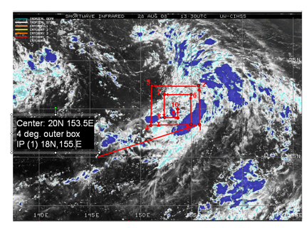
Flight route planning using CIMSS Tropical Cyclone Imagery. The red arrows represent a proposed flight pattern to investigate a potential Tropical Cyclone in the Pacific. The satellite imagery helps the mission planners identify the critical storm structure for further investigation.
GOES-R AWG Annual Review Meeting Held
The GOES-R Algorithm Working Group (AWG) held its annual meeting at the UW-Madison on June 23 – 26. The AWG was created to develop, test, demonstrate, validate and provide algorithms for the next generation of U.S. geostationary environmental satellites (GOES).
Members of the AWG held the conference to present the accomplishments of the AWG over the past year, reviewing progress in algorithm development and presenting results from the groups’ various product application teams. In addition, reports were prepared to inform the GOES-R Program Office and the AWG technical Advisory Committee on the status of the AWG and key issues facing future developments.
The AWG is developing 59 product algorithms that will be provided to the GOES-R Program Office. These products will be provided to forecasters and other users to improve environmental monitoring, severe weather warnings, and improved forecasts.
Individual meetings were held between the individual product application teams and the Algorithm Integration Team to review code development procedures.
Over 100 scientists from NOAA, its Cooperative Institutes, EUMETSAT and other partners contributed to the conference.
AWG algorithm development teams include:
Air Quality Products
Aviation
Cloud Products
Cryosphere
Hydrology
Land
Lightning
Ocean Dynamics
Radiation Budget
Space Weather
Sounding
SSTWinds
For further information concerning the conference and the GOES-R AWG, please visit the GOES-Rwebsite.
Summer 2008 Outreach Events
SSEC hosted several outreach events this summer, starting with a Teacher Workshop (http://cimss.ssec.wisc.edu/teacherworkshop/2008/) on July 9th and 10th. Twenty-eight educators from 5 different states traveled to Madison to learn about climate change and the 2007 IPCC Summary for Policy Makers. Remote sensing topics and global weather patterns were presented by Steve Ackerman and Margaret Mooney with the help of the Suomi Science Museum 3D Weather Globe. Tom Whitakker debuted his new Milankovic Cycles Climate Applet (http://profhorn.meteor.wisc.edu/wxwise/climate/earthorbit.html) demonstrating planetary orbits and past climates. Twenty-one teachers rated the workshop as an “excellent” experience; the rest marked the next best category in the evaluations. One teacher commented that the workshop was “the single best professional development class this year” (out of four).
SSEC also hosted two meteorology sessions for Grandparents University (GPU) in July with contributions from Jean Phillips, Shelley Knuth, Dave Turner and Megan Evanson. One of the most effective outreach events on campus, GPU brings two different and distinct age groups to our building: older adults interested in learning about pioneering and on-going remote sensing research at the Atmospheric, Oceanic and Space Science building, and school age children considering future careers and colleges.
Finally, the CIMSS 16th Student Workshop on Atmospheric, Earth and Space Science (http://cimss.ssec.wisc.edu/studentworkshop/2008/index.html) led by Gary Wade, Jordan Gerth, and Luke Schiferl was featured in the Wisconsin State Journal (http://www.madison.com/wsj/home/local/301107) in August.
Updated Proposal Page
If you work on proposals (or will perhaps someday), please stop by our updated proposal information page on the SSEC website!
http://www.ssec.wisc.edu/employee_info/proposals.html
The new updates include instructions for the new electronic approval step required for all proposals. This page is also useful if you feel lost about how to get started or if you have a question about the process. Please contact Jenny Stepp if you have any questions or feedback about the site content!
SSEC Appearances in the Media
8/8/08 – Wisconsin State Journal – Improved Satellites Bring Better Weather Forecasts to Earth. University of Wisconsin Researchers Have Played Key Role.
By Harvey Black
http://www.jsonline.com/story/index.aspx?id=781188
—
8/27/08 – Christian Science Monitor – Cloud-Sniffing Drones Soar Over Asia. We have an AERI in the portable atmospheric-radiation monitoring station mentioned in this article. Rest of the article is interesting too, even for a computer guy.
http://features.csmonitor.com/environment/2008/08/27/cloud-sniffing-drones-soar-over-asia/
—
8/17/08 – Wisconsin State Journal – Summer Student Workshop in the news:http://www.madison.com/wsj/home/local/301107
—
8/8/08 – Wisconsin State Journal – Article on the role of UW research in weather satellites.
—
4/08 – Wisconson Engineer Magazine – Article featuring the ICDS DISC team was a subject of an article “Return From the Bottom of the World” (Vol. 112, N 3, p.6-7, April 2008) published in May. See links: http://www.engr.wisc.edu/wiscengr/index.shtml and http://www.engr.wisc.edu/wiscengr//cgi-bin/article.php?article=apr08return
—
8/13/08 – Sarasota Herald/Tribune – “A Storm’s Fate: Hanging on Motes of Dust” (Amato Evan)
—
8/21/08 – Popular Mechanics – “Desert Storm Watch: Scientists Observe Saharan Dust to Predict the Next Big Hurricane Season” (Amato Evan and Andy Heidinger)
—
9/4/08 – Nature – “The increasing intensity of the strongest tropical cyclones.” (Matthew Lazarra)
—
7/9/08 – Wisconsin State Journal – Dave Martin interviewed by reporter Ron Seeley re: lightning.
—
8/08 – Weather and Forecasting Journal – paper submitted by Wayne Feltz
GOES-12 in Rapid Scan Mode
NOAA/NESDIS operated the GOES-12 satellite in continuous rapid scan mode, which meant that 7.5-minute-frequency imagery was available over the CONUS region and adjacent waters, around the clock (except for the 3-hr eclipse period and 8-hourly ‘keep-out zones’). The CIMSS TC group produced hi-res atmospheric motion vector fields from this imagery, every hour, from IR/SWIR and VIS.
It is hopeful that the key “players” in the environmental flow fields as talked about in NHC discussions will become apparent in these observations as storms make their way toward the U.S., complementing the G-IV environmental drops data.
CIMSS 2008 GOES-12 Rapid Scan Wind Product Archive
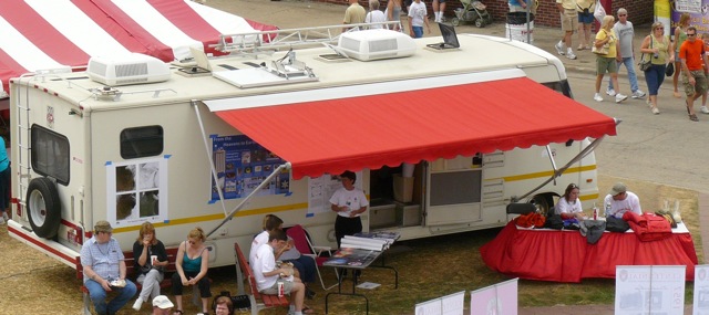
State Fair Appearance by AERIbago
SSEC’s Aeribago, the Winnebago outfitted with an AERI device, was part of the contingent representing the UW-Madison at the Wisconsin State Fair. Erik Olson piloted (and parked!) the vehicle and then gave tours of the interior to interested fair-goers. Maria Vasys, Margaret Mooney, Tim Wagner, Daniel DeSlover, Jonathan Thom, Shelley Knuth, Luke Schiferl and Mark Hobson answered questions and handed out SSEC materials.
New Alpha Version of McIDAS-V Now Available
The newest version of McIDAS-V, version 1.0alpha10, is now available for free download from the McIDAS Website – http://www.ssec.wisc.edu/mcidas/software/v
If you’re new to McIDAS-V, the training materials from the January workshop held here at SSEC are available at the bottom of the McIDAS-V Software page. The “Getting Started” chapter in the User’s Guide will also help to guide you through using the different types of data available with McIDAS-V.
For current McIDAS-V users, the most notable changes since 1.0alpha9 are the addition of local McIDAS AREA servers accessible from the new satellite imagery chooser, the ability to drag and drop image display tabs, and increased HYDRA functionality.
We’re always looking for user feedback, so if you see something that’s not working correctly or some functionality that you’d like to see added, please send a support request to McIDAS-V Support or use the Support Request Form in the Help menu of McIDAS-V.
Would you like to provide input into the development of McIDAS-V?
Occasionally when we’re trying to decide how some piece of McIDAS-V should function, we’ll solicit feedback from the McIDAS-V group by sending out screen shots with the available options or by scheduling short meetings to discuss the options. Also, approximately once per month, we have McIDAS-V Team meetings where the developers demonstrate what they’re working on in McIDAS-V and look for user feedback. If you’d like to be added to this McIDAS-V group, please respond to this e-mail, and we’ll be sure that you’re added to the list.
Remember — this is still an alpha version of McIDAS-V, which means that there may be bugs in the software that we have not yet found or fixed. It also means that the user interface and functionality has not yet been finalized. If you’re interested in providing input into the development of McIDAS-V, there is still time to have your voice heard!
Honors:
Dave Tobin received the “Young Scientist Award” from the the International Radiation Symposium.
—
Allen Huang was named as SPIE Fellow for his career contributions.
—
Jordan Gerth was the 2008 Wisconsin Space Conference undergraduate nominee to represent Wisconsin at the joint NASA Future Forum and Great Midwestern Space Conference in Chicago on October 10th with his poster, “Enhancing Numerical Weather Prediction Initial Conditions with MODIS.”
—
Wayne F. Feltz, Patrick W. Heck, Anthony J. Wimmers, and Michael J. Pavolonis were part of the NASA Advanced Satellite Aviation-weather Products (ASAP) Project Team which received the 2007 Paul F. Holloway Non-Aerospace Technology Transfer Award.
—
Dr. Matthew Lazzara recieved his PhD in Atmospheric and Oceanic Sciences – from the AOS department. Title of his thesis: “A diagnostic study of Antarctic fog.”
Library News
By Jean Phillips
(Eos Trans., AGU, v.89, no.28, p257)
The American Geophysical Union is probably the first important publisher in the earth sciences to decide to stop printing its journals. By 2011, all AGU journals, except EOS, will be online-only products. In 2002, the AGU made the electronic journal the version of record. To address concerns about the longevity of its journals, the AGU:
has taken steps to ensure the continuing availability of its archived online material such as using only nonproprietary software, converting text and graphics to file formats that can be carried forward, endowing a dedicated long-termcare trust fund, and arranging to have redundant copies of its online material on three different tectonic plates. These steps not only protect the archive but also assure that the content of journals can be migrated to new formats as technology changes.
The University of Wisconsin-Madison libraries converted all of its print subscriptions (except EOS) to electronic access only in fall 2007. The libraries now provide electronic access to all of its AGU subscriptions from volume 1 to date.
To recap, the campus subscribes to the following AGU journals:
Journal of Geophysical Research (all series)
Geophysical Research Letters
Reviews of Geophysics
Global Biogeochemical Cycles
Paleoceanography
Water Resources Research
Tectonics
Journals can be accessed from the campus E-Journals list or from the Schwerdtfeger Library Electronic Journals.
How Can Authors Pay for Open Access Charges?
Earlier this year, the University of California at Berkeley launched the Berkeley Research Impact Initiative, a pilot program co-sponsored by the University Librarian and the Vice Chancellor for Research to cover publication charges for open-access journals. Faculty, post-doc and graduate students can apply for up to $3000 to cover the cost of publishing an article in an open-access publication.
At the University of Wisconsin-Madison, the library’s Scholarly Communication and Publishing Committeeis preparing draft guidelines and criteria to include fund guidelines and a funding process to help authors who want to publish in open access journals. That work is expected to be completed over the summer. Currently, the libraries have seed money in a gift fund which has helped some authors defray as much as $1500 of open access publishing costs.
Better Access to Scientific Articles on EU-Funded Research
The European Commission wants to ensure that the results of the research it funds are disseminated as widely and effectively as possible to guarantee maximum exploitation and impact in the world of researchers and beyond. The Commission launched a pilot project that will give unrestricted online access to EU-funded research results, primarily research articles published in peer-reviewed journals, after an embargo period of between 6 and 12 months. The pilot will cover around 20% of the Research Framework Programme’s (FP7) budget in areas such as health, energy, environment, social sciences and information and communication technologies.
To read more about it, see the EU’s recent press release.
The Future of Science: Building a Better Collective Memory
Historically, the culture of science has rewarded shared discovery with prestige and jobs. Michael Nielsen, in a recent blog-essay discusses the culture of science and how, in his view, it is tending to retard adoption of collaborative tools and open access. He contends that “the internet offers us the first major opportunity to improve this collective long-term memory, and to create a collective short-term working memory, a conversational commons for the rapid collaborative development of ideas. The process of scientific discovery – how we do science – will change more over the next 20 years than in the past 300 years.”
From CIMSS:
Latin American Data Workshop:
Tom Whittaker, representing the Cooperative Institute for Meteorological Satellite Studies (CIMSS), made four presentations and conducted two workshops during the Latin American Data Workshop, held August 21-23, 2008, at the University of Sao Paulo in Sao Paulo, Brazil. This workshop was attended by more than 50 representatives from several Latin American countries as well as the United States. The presentations were:
- an overview of data and research activities at CIMSS,
- an introduction to McIDAS-V,
- an overview of VISITview (VISIT is the Virtual Institute for Satellite Integration Training), and
- examples of Educational Applets developed at CIMSS.
The two hands-on workshops were for McIDAS-V and VISITview, and provided an opportunity for attendees to gain experience with these tools. (T. Whittaker, CIMSS, 608-262-2759)
GOES-13 Sounder Products Produced at CIMSS:
Several Derived Products Images (DPI) based on data from the currently experimental Geostationary Operational Environmental Satellite (GOES)-13 Sounder are being produced at the Cooperative Institute for Meteorological Satellite Studies (CIMSS). The imagery consists of Total Precipitable Water (TPW), Lifted Index (LI) and Cloud Top Pressure (CTP). In general, the values from GOES-13 are qualitatively similar to those from GOES-12, although the cleaner signal of GOES-13 is evident. Near real-time images from GOES-13, as well as similar imagery from the operational GOES-11 and -12 Sounders, are being posted at: http://cimss.ssec.wisc.edu/goes/rt/sounder-dpi.php (T. Schmit, E/RA2, 608-263-0291,tim.j.schmit@noaa.gov, J. Nelson, CIMSS, 608-263-6013, T. Schreiner, CIMSS, 608-263-6754)
CIMSS VISIT Activities:
The Virtual Institute for Satellite Integration Training (VISIT) distance learning lessons “Mesoscale Convective Vortices” ( http://rammb.cira.colostate.edu/visit/mcv.html ) and “Moderate Resolution Imaging Spectroradiometer (MODIS) Products in Advanced Weather Information Processing System (AWIPS)” ( http://cimss.ssec.wisc.edu/goes/visit/modis.html ) were led by staff from the Cooperative Institute for Meteorological Satellite Studies (CIMSS) on August 27 and 28, 2008. Forecasters from the National Weather Service offices in Chicago, Illinois, Glasgow, Montana, and the Spaceflight Meteorology Group in Houston, Texas, participated in the VISIT lessons. In addition, several new examples of Geostationary Operational Environmental Satellite (GOES-13) imagery were added to the CIMSS Satellite Blog (http://cimss.ssec.wisc.edu/goes/blog/archives/category/goes-13 ) to help evaluate the performance of GOES-13 during the most recent operational testing period. (S. Bachmeier, CIMSS, 608-263-3958, S. Lindstrom, CIMSS)
(Click image to enlarge)
Figure caption: 3.9 micrometer shortwave IR and 0.65 micrometer visible channel imagery from GOES-11, GOES-12, and GOES-13, showing a hot spot and smoke plume associated with a wildfire that was burning in southeastern Montana on August 22, 2008.
Manuscript Accepted in Monthly Weather Review:
The article describing our new algorithm that assigns probabilities of secondary eyewall formation in hurricanes has been accepted for publication in Monthly Weather Review. The algorithm was developed largely under a GOES-R Risk Reduction project. (J. Kossin, CIMSS, 608-265-5356, M. Sitkowski, Univ. of Wisc., AOS)
CIMSS Products Support the Tropical Prediction Center: During the recent flurry of Atlantic hurricane activity, the NOAA Tropical Prediction Center made extensive use of satellite-derived products. Among them were algorithms used to estimate intensity, such as the Advanced Dvorak Technique, and Advanced Microwave Sounding Unit (AMSU)-based methods from the Cooperative Institute for Meteorological Satellite Studies (CIMSS) and the Cooperative Institute for Research in the Atmosphere (CIRA). Analyses of shear were critical to decision making on intensity forecasts, and the shear products derived from GOES winds by CIMSS were utilized on many occasions. (C. Velden, CIMSS, 608-262-9168) Global+RSO WFABBA in Testing at Operations:
Version 6.5 of the Geostationary Operational Environmental Satellite (GOES) Wildfire Automated Biomass Burning Algorithm (WF_ABBA) was delivered to NESDIS Operations by the biomass burning team at the Cooperative Institute for Meteorological Satellite Studies (CIMSS). The WF_ABBA, with support for processing all available data in real-time with a low latency from GOES-8/-9/-10/-11/-12/-13, Meteosat (Met)-8/-9, and Multi-Functional Transport Satellite (MTSAT)-1R, will undergo testing at NESDIS Operations before being certified as operational. WF_ABBA version 6.0 became operational in 2002 and since then has been detecting and characterizing fires on a half-hourly basis for GOES-East and GOES-West. WF_ABBA version 6.5 meets the requests for GOES Rapid Scan Operation (RSO) and global geostationary fire detection and characterization. (C. Schmidt, CIMSS, 608-262-7973, R.B. Pierce, E/RA2, 608-890-1892, brad.pierce@ssec.wisc.edu)
GOES-R Risk Reduction Annual Review: The GOES-R Risk Reduction annual review was held in the NSOF building in Suitland, MD on September 3-4, 2008. Tom Achtor (CIMSS), Allen Huang (CIMSS), and J. Key (ASPB) attended. The meeting was chaired by Ingrid Guch and Mark DeMaria (STAR). The review covered a broad spectrum of activities in STAR, the cooperative institutes, and other NOAA entities. (J. Key, E/RA2, 608-263-2605, jkey@ssec.wisc.edu)
Upcoming Events
6th GOES Users’ Conference and 50th Anniversary Meteorological Satellite Experiment Symposium
– Monona Terrace Convention Center — Madison, WI
The Events:
50th Anniversary of 1st meteorological satellite experiment – 2 November 2009
The 50-year anniversary of the 1st meteorological satellite experiment (on Explorer VII) will be commemorated on Monday, November 2nd (2009). The late afternoon/early evening event will consist of presentations, followed by an icebreaker at the Monona Terrace. The experiment, flown on Explorer VII, measured the radiative energy balance of Earth. The architects of the radiometer were the University of Wisconsin’s V. Suomi and R. Parent.
NOAA 6th GOES Users’ Conference (GUC) – 3-5 November 2009
The 6th GOES Users’ Conference will again consist of an overview of the current, near-term and future GOES systems, along with break-out sessions to inter-act with a host of data producers and users. GOES-R, slated to be launched in FY2015, will provide critical atmospheric, oceanic, climatic, solar, and space data. These new satellites will provide the user community (television and NWS meteorologists, private weather companies, aviation and agriculture communities, and national and international government agencies) with significantly more data, containing noteworthy improvements in temporal and spatial resolutions over data currently provided. Abstracts and corresponding posters are solicited for this conference on both current and future GOES data, products and applications. Information on past conferences
EUMETSAT Conference:
A. Heidinger and T. Schmit will participate in the European Organisation for the Exploitation of Meteorological Satellites (EUMETSAT) Meteorological Satellite Conference in Darmstadt, Germany, 8-12 September 2008. The oral presentations are respectively titled “Towards a consensus calibration of the Advanced Very High Resolution Radiometer (AVHRR) reflectance channels for climate studies” and “Geostationary Operational Environmental Satellite (GOES) derived product images: Past, present and future.” (T. Schmit, E/RA2, 608-263-0291, tim.j.schmit@noaa.gov)
Seminar on Tropical Cyclones – Greg Tripoli
I would like to call your attention to the AOS 955 seminar that I am offering this Fall semester on Wednesdays from 9:55:10:45 am in room 1411. I plan to have the weekly seminar focus on student and Research Scientist presentations on subjects pertaining to tropical cyclones that might include:
- interesting aspects of the current or other TC seasons
- the background behind ongoing national debates concerning tropical cyclones such as those occurring on the tropical cyclone email list or in the media,
- lines of TC research ongoing in the AOS building
- reviews of completed studies appearing in the scientific literature,
- climate of tropical cyclones or historic tropical cyclone events
or any other topic concerning tropical cyclones. I would also like to explore the possibility of having /a short (5-10 minute) weekly discussion /summarizing the overall TC activity occurring across the globe for the week and that expected for the coming week . I view this class as a chance for the rather large UW tropical cyclone research community to get together and discuss these topics for the benefit of the students as well as ourselves. I invite all of you who are involved with tropical cyclone research (or those who have an interest) to participate in this weekly discussion and perhaps present your own research at some point during the semester. Please join us for our first organizational meeting Wednesday, September 3 . I will be open to additional suggestions concerning the organization of this class and even the possibility of moving it to a more convenient time if the this meeting time is a problem.
Greg Tripoli
Professor
Rm 1431
Phone: 608 217-6748 (cell)
New On-line Course on Global and Regional Climate Change
SSEC debuted a new on-line professional development course this summer presenting /Global and Regional Climate Change /(http://cimss.ssec.wisc.edu/climatechange/) topics to 15 middle and high school science teachers. Course content was developed collaboratively by faculty and staff from the Cooperative Institute for Meteorological Satellite Studies, the Center for Climatic Research, the Atmospheric and Oceanic Sciences Department, and the Geology and Geophysics Department.