Monthly News Summary – October 2007
Visualizing the future with McIDAS-V
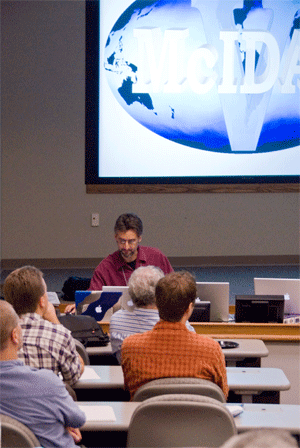
Image Courtesy of Maciek Smuga-Otto
After 35 years, the legacy of SSEC’s geophysical data processing software continues. From October 16-18, more than 60 programmers and scientists gathered to discuss and try out the next step in the evolution of McIDAS. Attendees included many members of the McIDAS Users’ Group (MUG)—some of whom traveled from around the world.
The conference kicked off with an overview of the current state of satellite data options, including acquisition and processing. In addition to a summary of current weather satellite capabilities, participants heard about SSEC’s current online data archive and data ingestion facilities. Jay Heinzleman and Dave Santek also gave a presentation about recent updates to the current iteration of McIDAS—McIDAS-X.
After assessing the present, the conference switched to focus on the future of satellite data analysis and visualization tools. Steve Ackerman explained why users need the functions that McIDAS-V will offer in the hyperspectral age. After lunch the group was given the first public viewing of McIDAS-V.Jessica Staude and Becky Schaffer gave a demonstration of the new software. A lively group discussion followed.
During the final day of the conference, attendees had the chance to try out the alpha version of McIDAS-V. McIDAS development coordinators hope to offer a free download of a beta version McIDAS-V some time this winter. Check out the meeting summary page for links to presentations, the participant survey and the McIDAS commercials.
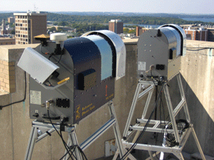
Image Courtesy of Maciek Smuga-Otto
With support from NSF, SSEC recently added two new instruments to the rooftop suite. Data from these instruments will enhance that obtained from the center’s existing collection.
Perhaps you’ve seen the two new “mailboxes” on the SSEC roof, and wondered, “What are those?” Well, they are two new microwave radiometers obtained through a Major Research Initiative grant from NSF. These radiometers compliment the suite of instruments that SSEC has deployed on the roof and in the ‘Bago. SSEC uses the collection to support field experiments around the world.
The two new instruments expand our wealth of information about the atmosphere. The blue radiometer provides observations that scientists can use to create profiles of the temperature and water vapor in the air above the radiometer. The instrument also assesses the total amount of water vapor and liquid water. The gray radiometer gathers observations that are about three times more sensitive to liquid water than the measurements from the other radiometer, so the gray instrument provides more accurate estimates of liquid water in the clouds above it. Both radiometers are hardened instruments and are designed to collect data 24/7 in all weather conditions.
Dave Turner, Erik Olson, and others continue to work with the vendor to understand the operational nuances of the systems and to optimize these radiometers for our use at SSEC.
–Dave Turner
Joining forces as partners for our weather, climate and environment
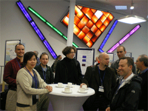
Many SSEC scientists attended the joint meeting in Amsterdam.
With the word ‘global’ taking on increasing significance in conversations about our planet’s weather, climate and environment, Europe and the U.S. joined together to organize a conference to promote developments in the use of environmental satellites in studies of the Earth. Following an initiative first proposed almost six years ago by SSEC scientist Chris Velden, EUMETSAT and NOAA joined with AMS to host the joint conference in September 2007. The Royal Netherlands Meteorological Institute graciously agreed to serve as the local host and the stage was set in Amsterdam, the Netherlands—a beautiful city sometimes called “the Venice of the North.”
Perhaps inspired by the interest of operational and research communities and the very attractive venue, over 600 participants attended the conference. Organizers believe that this meeting took the record as the largest gathering of environmental satellite scientists, researchers and operators. Due to the number of participants, the conference’s Scientific Programme Committee, which included Wayne Feltz and Tim Schmit, elected to choose a limited number of oral presentations with a select few as keynote speeches. The vast majority of the abstracts were featured during poster sessions.
High quality presentations and posters covered ten topics:
- New and Future Satellite Programmes and Instruments
- Assimilation in NWP, Ocean, and Coupled Ocean-Atmosphere Models
- Operational Applications
- Environmental Applications
- Oceanography
- Atmospheric Composition
- Climate and Long-term Data Sets
- Cloud Processes (cloud properties, precipitation, etc.)
- Hyperspectral Studies
- Retrieval Methods
By bringing together diverse members of the international research community, organizers hoped that the conference would encourage unified international collaboration among those involved with transferring environmental satellite research into operations. The many presentations and posters spanned the past and present generation of satellite systems already in orbit with the next generation of higher-performance systems being readied for launch. Some contributors also provided a look ahead to future generations of research and operational satellites that will use advanced, cutting edge technologies. In this spirit, the joint European/U.S. NPOESS program received a lot of attention.
SSEC/CIMSS had a significant presence at the conference with more than 35 attendees. Our researchers gave talks and posters in every session. Several served as keynote speakers and session chairs. The influence of the work we are doing here in this building was certainly felt at this historic conference.
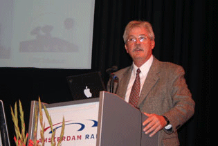
During a special session, the scientific community honored Paul Menzel and his contributions to atmospheric science.
Perhaps the highlight of the conference was a special session devoted to the contributions of our own Paul Menzel. The scientific community honored his recent retirement from NOAA after forty years of service with a special plaque recognizing his contributions to the global understanding of atmospheric science and his enduring commitment to international collaboration. After a presentation by Paul on the history of the GOES program, several close colleagues and friends spoke briefly about his important role in the science community and his dedicated mentoring efforts over the years. It was truly a special afternoon for a special colleague.
The success of such a meeting can be measured in many ways. New collaborations, exposure for our younger scientists, and the exchange of knowledge between global partners are all metrics from which to gauge that success. Perhaps the greatest testimony to the success of the conference is the proposal from EUMETSAT and NOAA to “let’s do this again soon!”
–Chris Velden
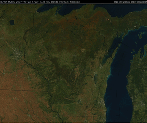
Autumn arrives in the Midwest—Looking down on the Midwest, a satellite-based imaging instrument captured the arrival of autumn. A series of images from early August through late September shows the transition from dark green foliage to browns and brilliant oranges as the leaves on trees change color and the cornfields mature. Scott Bachmeier posted these animations and descriptions on 22 September in the CIMSS Satellite Blog. Bachmeier pointed out that the drought conditions in the Midwest might have stressed the trees and contributed to the relatively early change in colors.
Surf’s up—SSEC visualization experts recently collaborated with Hawaii’s Bishop Museum to create images of a high surf event that occurred in February 2006. The museum will display the images on a Science on a Sphere—a six-foot diameter sphere for showcasing planetary data. The surf images include infrared satellite data, surface isobars, surface streamlines, wave heights and wave periods. Here is an example of the streamlines over the wave heights. Rich Kohrs and Tom Whittacker created this imagery.
Land remote sensing talk—Sam Batzli presented an overview of the AmericaView consortium to the annual meeting of the National States Geographic Information Council (NSGIC) on September 26. Batzli runs the WisconsinView program and is vice-chairperson of the AmericaView Board of Directors. AmericaView receives an annual grant from the US Geological Survey to enhance the distribution of land remote sensing data, products and technology at the state level. While NSGIC represents state-level GIS coordination, AmericaView is quickly becoming the coordinating body for state-level land remote sensing data. The six-year-old consortium currently has 30 active “StateViews” with new states joining each year. In addition to a large quantity of Landsat data, WisconsinView makes one-meter resolution color aerial photography of the entire state available online as free downloads. See www.wisconsinview.org for more information.
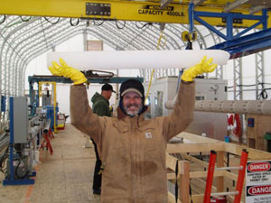
One of ICDS’s engineers holds the first core taken with a new drill.
“Ice Drillers are Hard Core”—A trip to Antarctica inspires curiosity in many. Recently, a videographer traveled to the southernmost continent to capture a “day in the office” for those whose jobs require them to deal with some of the least hospitable conditions on the planet. In the video, drillers with SSEC’s Ice Coring and Drilling Services (ICDS) talk about how they cope with the hard work, harsh environment and loneliness.
The movie about the drillers is a part of the Passport to Knowledge series, which is a series of interactive learning modules on various science themes. Sponsored by NASA, NOAA and NSF, the Passport to Knowledge series includes a PolarPalooza tour going on this fall. ICDS’s Charlie Bentley will speak at two museums as a part of this tour. More on this tour next month.
Award for CALIPSO achievement—Andy Heidinger (NOAA at SSEC) received a NASA Group Achievement Award for his work as a part of the science team for NASA’s Cloud-Aerosol Lidar and Infrared Pathfinder Satellite (CALIPSO). NASA launched CALIPSO in April 2006. CALIPSO data helps scientists understand how clouds and aerosols contribute to the Earth’s weather, climate and air quality. The team received the award for “exceptional achievements in the successful development, launch, and operation of the CALIPSO satellite.”
Recently published paper—The Journal of Applied Remote Sensingrecently published a paper by Xuanji Wang and Jeff Key (NOAA at SSEC). Titled “Dirunal cycles in Arctic surface radiative fluxes in a blended satellite-climate reanalysis data set,” the paper appeared on 13 September.