Monthly News Summary – April 2007
PAW on your desktop
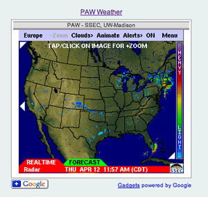
Russ Dengel and Bill Bellon created a Google Gadget for the PAW. Here is a screenshot of the gadget incorporated in a web site.
Weather lovers can now easily access the latest meteorological information on their desktops with a new adaptation of a PDA-friendly weather Web service created by SSEC’s Russ Dengel.
Dengel’s free PDA Animated Weather service, known simply as PAW, provides access to real-time radar and satellite weather images and forecasts whenever and wherever. Using thePAW Google Gadget, anyone can plop a personalized version of tool onto a desktop or incorporate it into a web site. Dengel worked with SSEC webmaster Bill Bellon to create the gadget.
The new PAW gadget has already received praise. Nat Adcock of Pocket PC Magazine commented on the gadget in an April 10 post. “Of course, there are a ‘plethora’ of mobile weather tools available BUT PAW is my favorite! (sic)” he wrote.
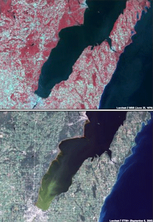
ERSC contributed three maps and scientific expertise to an exhibit of Great Lakes maps at UW-Madison’s Memorial Library.
Original maps of Wisconsin and the Great Lakes region from 17th-century drawings concocted from travelers’ accounts to 21st-century images captured by satellites are on display through June 29 in the Department of Special Collections in Memorial Library at the University of Wisconsin-Madison.Read the full UW-Madison news release.
SSEC’s Environmental Remote Sensing Centercontributed satellite images to this exhibit.Jonathan Chipman also discusses the images in the podcast that accompanies the maps and images.
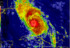
Chris Velden and Dave Stettner contributed to the development of this simulated hurricane as it descends on Florida.
Hurricane help—CIMSS’s Tropical Cyclones research group provided prompt assistance with a hurricane simulation for the National Hurricane Center. Chris Veldenand Dave Stettnersupplied data sets that were crucial to the development of a piece of an emergency management exercise. The data sets contributed to an animation that simulated landfall of a hurricane near West Palm Beach, FL. “Without their (UW-CIMSS/SSEC) prompt and quick help, this landfall simulation would not be possible,” says a programmer with the hurricane center.
Balloons for forecasts—The Milwaukee Journal Sentinel printed a story about weather balloons in the paper’s March 15 edition. Chris Velden, leader of the CIMSS Tropical Cyclones group, contributed to the article. Velden explained that observations collected by weather balloons are important for weather prediction models because these data contribute to the starting point from which the model creates a forecast. He also said that satellites will likely replace weather balloons completely in the near future, but, currently, weather balloons gather critical data about meteorological conditions and phenomena.
A cloudy view of clouds—The World Climate Report, a climate change blog, recently posted a summary and analysis of Amato Evan and Andy Heidinger’s recent paper published in Geophysical Research Letters. The paper detailed results from a study indicating that the large decrease in the amount of clouds covering the Earth likely results from a change in satellites’ perspective. The study delves into a record compiled over several decades by the International Satellite Cloud Climatology Project (ISCCP). According to the blog post, the “Wisconsin researchers take a very critical look at exactly how these well-regard and well-used ISCCP data are computed and the problems inherit in using such data.” The author of the post concludes “it is very hard to reach good, viable conclusions about climate change when the basic input data are inherently bad.”
From the roof to WeatherUnderground—Since mid-2006, data from SSEC’s Rooftop Instrument Group (RIG) has had its own place on WeatherUnderground. The RIG provides information about the temperature, dew point, pressure, wind speed and direction, and rainfall rate from the top of the Atmospheric, Oceanic and Space Sciences building on the UW-Madison campus.
New AWIPS addition—CIMSS researchers have integrated a new satellite data product into the Advanced Weather Interactive Processing System (AWIPS), which the National Weather Service uses to process and analyze weather data. NWS forecasters now have access to cloud images derived from the sounding instrument aboard Geostationary Operational Weather Satellites. Forecasters can use these Effective Cloud Amount Derived Product Images to assess the accuracy of sky cover forecasts or to aid in predicting high and low temperatures.
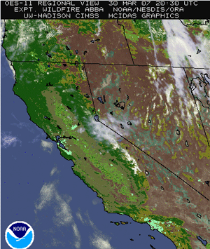
The CIMSS Wildfire ABBA detected the fire in California’s Hollywood Hills.
From the satellite blog—On March 30,Scott Bachmeier posted satellite images of a fire in California’s Hollywood Hills. Allegedly set by arsonists, the CIMSS Wildfire Automated Biomass Burning Algorithm (ABBA) detected the fire. Images from the MODerate resolution Imaging Spectroradiometer (MODIS) clearly showed the smoke plume as it developed.
Recently, an avid follower of the CIMSS Satellite Blog e-mailed Bachmeier with praise. This reader is part of the space flight hardware industry. “It’s nice to see real-world applications for some of our hardware, and I just wanted to let you know that I’ve been really enjoying the blog …especially the animations! Keep up the good work!”
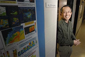
Wisconsin Week recently featured a profile of Allen Huang.
Photo: Aaron Mayes
CIMSS scientist profiled—The March 28 edition of Wisconsin Week, a campus newspaper, featured a profile of CIMSS’sAllen Huang. Research scientist Allen Huang is at the forefront of preparations for new satellite instruments and the predicted data deluge. Huang’s contributions will improve severe weather forecasts and environmental monitoring and lead to a better understanding of the Earth’s changing climate. Read the full article.
Find our imagery in Wikipedia—SSEC data and imagery appear often in various media. Over the last few years, several articles in Wikipedia have used SSEC images to illustrate a variety of concepts and have referenced SSEC data. For example, an image of Tropical Cyclone Monica accompanies an article on tropical cyclones.
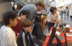
Visitors explored the atmosphere at SSEC’s Science Expeditions booth.
Science Expeditions—On March 24, more than 1700 visitors visited UW-Madison’s annualScience Expeditions, a day of family-friendly science experiences. At the event, SSEC’sMargaret Mooney andJen O’Leary presented an exhibit called “Explore the Atmosphere.” At this booth, participants used a variety of online educational tools to understand severe weather and other atmospheric concepts. SSEC’s Environmental Remote Sensing Center also had an exhibit, “Wisconsin from Space.” Here, visitors used 3-D glasses to check out images of Wisconsin and engaged in activities to understand applications of remote sensing technology. Tim Olsen coordinated this booth.
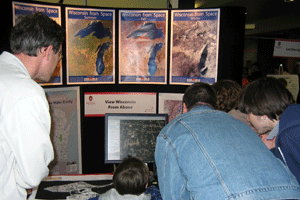
ERSC showed visitors Wisconsin from space at Science Expeditions.
Science with coffee—Steve Ackerman spoke with community members about severe spring weather at Crossroads Coffeehouse on April 3. Ackerman gave an engaging presentation and then stayed to answer questions. “Steve was great!” organizer Terry Devitt says. “He was the perfect person to lead off the series.” University Communications hopes that this type of event will help bring science to the public in informal settings.
Polar presentation at library—An audience at Mount Horeb Public Library learned about weather and research on the planet’s coldest, driest and windiest continent–Antarctica. Matthew Lazzara discussedmeteorology, the network of Automatic Weather Stations on the continent, and how scientists use weather satellites to track and monitor Antarctic icebergs. Lazzara brought with him a sample ice core and a set of Extreme Cold Weather gear. The librarian had a chance to try on the gear, which together weighs about 30 pounds.
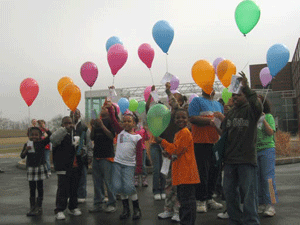
Students launched “weather balloons” after a presentation on Wild Weather Saturday.
Wild Weather Saturday—Also on March 24th, Rosalyn Pertzborn, director of SSEC’s Office of Space Science Education, and Professor Michael Morgan from UW-Madison’s Department of Atmospheric, Oceanic and Space Sciences gave a presentation for “Wild Weather Saturday.” This event is a part of a Saturday lecture series organized by the African American Ethnic Academy Science and sponsored by Madison’s BioPharmaceutical Technology Center Institute (BTCI). Pertzborn explained some basic information about the weather to more than thirty students representing most of the city’s elementary schools. Prof. Morgan then shared some of his own personal wild weather experiences, including a tornado ripping through his backyard and a trip to the New Orleans area to observe conditions leading up to and during Hurricane Katrina.
Following a lively discussion with many excellent questions, students had the opportunity to conduct a weather experiment of their own. After viewing animated real-time US composite satellite images, each student used a map of the upper Midwest to predict where their own “weather balloon” and payload would likely be recovered. As of April 11, BTCI has received several of the payloads and are anticipating more as the April snow melts.
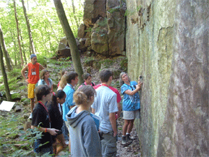
The CIMSS High School Summer workshop includes an Earth science field trip to Devil’s Lake.
Calling all high school students—If you know a high school student with an interest in science, CIMSS has the ideal summer workshop. From July 22 -26, participants will enjoy an exciting four-day agenda in meteorology, astronomy, land remote sensing and geology. Students will have a unique opportunity to learn directly from research scientists through hands-on activities and educational adventures. Applications are available online and are due on April 27.
Elected to federal climate change committee—CIMSS research scientistJim Kossin has started his appointment to the United States Climate Change Science Program, which integrates federal research on climate and global change. Kossin contributes his expertise and research on tropical cyclones and long-term trends of this type of storm.