Monthly News Summary – August 2006
Downpour causes flash flooding
|
|
|
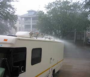
SSEC’s home in the Atmospheric, Oceanic, and Space Sciences Building received approximately four inches of rain on July 27. Above shows the rain pouring off of the mobile weather lab, the AERIbago, parked behind the building.
|
During the early afternoon of July 27, a sudden downpour set cars adrift and caused damage to several facilities on the UW-Madison campus. According to National Weather Service estimates, the area received somewhere between three to five inches in only a couple of hours.
Due to damage from the storms the previous week, researchers at the Space Science and Engineering Center were unable to measure the amount of precipitation using the rain gauge on the roof of the Atmospheric, Oceanic and Space Sciences building. However, SSEC researcher Scott Lindstrom reported 4.15” at his home about a mile from the building.
 |
|
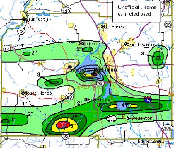
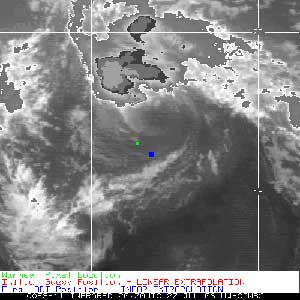
This unofficial Dane County rain map for July 27 shows two areas of heavy rain fall–one that is directly above the UW-Madison campus.
|
According to Scott Bachmeier, a research meteorologist at SSEC, Madison has only received more that four inches of rain in one day three other times since the city began maintaining weather records in 1869. Using Lindstrom’s measurement, July 27 takes its place as one of the top four rainiest days on record in Madison.
Bachmeier reported that the rainfall came from two narrow bands of clouds that extended from east to west. The bands formed quickly, but then proceeded to move very slowly over the Madison area. Bachmeier said that the storm’s structure resulted in “a very impressive rainfall gradient.” While Madison received around four inches of rain, Middleton, located just west of Madison, received less than an inch.
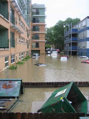 image courtesty of Maciek Smuga-Otto
|
|
The storm drainage facilities couldn’t handle the downpour and flash flooding resulted.
|
Madison’s downtown and campus areas received the most rain. These areas have a dense population of buildings, paved roads and other non-absorbent surfaces. The storm drainage facilities could not handle the downpour on July 27 and flash floodingresulted. According to a UW news release, 68 sites on campus reported water problems and several people observed cars adrift in campus parking lots.
When the rain let up, the UW Police Department called on SSEC to see if Madison would experience any more exciting weather that day. Tom Achtor helped a lieutenant from UWPD interpret satellite and radar data. The Police Department knew to contact SSEC because the center provides point forecasts for Camp Randall Stadium during home football games.
Data from the roof on Weather Underground—Weather Underground, an online weather repository, now features data from the instruments on the roof of the Atmospheric, Oceanic and Space Sciences building. Tom Whittaker (SSEC) created a “weather station” account that uses measurements from SSEC’s Rooftop Instrument Group (RIG) and updates every five minutes. The RIG provides the site with information about pressure, temperature, dew point, wind speed and direction, relative humidity, wind gusts, rain rate, and daily rain accumulation.
Direct broadcast to Milwaukee/Sullivan—In July, the National Weather Service station in Milwaukee/Sullivan began receiving data from SSEC’s direct broadcast facility. SSEC’s direct broadcast system obtains data in real time from the MODerate Resolution Imaging Spectroradiometer (MODIS), an imaging instrument aboard two polar-orbiting research satellites. SSEC generates images using this data and then delivers the images to Milwaukee/Sullivan. The NWS station in Riverton, WY also began using MODIS data from SSEC’s direct broadcast facility.
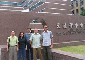 image courtesy of Steve Dutcher image courtesy of Steve Dutcher |
|
A team from SSEC went to Taiwan to help the Taiwan Central Weather Bureau with processing and visualizing satellite and other meterological data.
|
Traveling to Taiwan—A handful of SSEC researchers and computer experts traveled to Taiwan in early July to help theTaiwan Central Weather Bureau (CWB) improve its capacity to process and visualize satellite and other meteorological data. The group consisted of Kathy Strabala (CIMSS),Jerry Robaidek(SSEC), Allen Huang(CIMSS), Tom Rink (CIMSS), and Steve Dutcher (CIMSS). Using relevant data, the group demonstrated McIDAS and IDV. Developed at SSEC in the 1970s, McIDAS is a software package that handles remote sensing data. IDV is a java-based application used for visualizing and analyzing data. Personnel at CWB particularly appreciated IDV’s 3-D visualization capacity, and the data fusion and display capabilities of McIDAS. The demonstrations so impressed those at CWB that they purchased a license to operate McIDAS.
The CWB also requested assistance improving its Web site. SSEC’s Webmaster Bill Bellon reviewed their site and suggested improvements. He recently sent a reformatted version of the site to CWB. This included a page featuring numerical weather prediction loops created using McIDAS andsoftware developed by Tom Whittaker (CIMSS). Robaidek showed personnel at CWB how to create their own real-time automated loops. This successful trip was the first phase of collaboration between SSEC and CWB. Despite high temperatures and humidity, the group from SSEC enjoyed their experience. “One of the hardest things I had to figure out was the subway system,” Dutcher, an associate instrument technician, said.
Simulated dataset to test GOES-R science algorithms—CIMSS researchers used the Weather Research Forecast (WRF) model to generate a simulated atmospheric profile dataset. The dataset provided the necessary input to run the Geostationary Imaging Fourier Transform Spectrometer (GIFTS) forward radiative transfer model. Using this model, CIMSS researchers generated top of atmosphere radiances that will be used to test several science algorithms that will process the data from instruments aboard future generations of geostationary satellites, specifically GOES-R. CIMSS researcher Jason Otkin reported that the simulated data matched well with actual satellite data depicting a variety of weather conditions. “To see [simulated] images like these definitely made me smile,” Otkin said during a presentation about the project.
Meetings and Field Experiments
Comparing cloud climatologies—CIMSS hosted a workshop from July 6-7 that focused on assessing cloud properties. Bryan Baum (CIMSS) co-organized this event. The main goal of the workshop was to assess the state of current cloud climatologies and to determine the major causes of differences among them. Paul Menzel (NOAA at SSEC) was the chair for a session on long-term cloud datasets, which included discussions of cloud properties derived from satellite data and the utility of such properties in climate studies. Andy Heidinger (NOAA at SSEC) reported on the status of PATMOS-X and gave an overview of how it compares with other climatolgoies. Also during this session, Don Wylie (SSEC) explained how diurnal cycles and sensor scan angles affect cloud observations from satellites. Steve Ackerman (CIMSS) was the chair for a later session centered on techniques for identifying likely artifacts in cloud data from satellites and trends in cloud types established using surface observations.Richard Frey (CIMSS), Brent Maddux (CIMSS), Amato Evan(CIMSS), Liam Gumley (CIMSS), Iliana Genkova (CIMSS), Bob Holz(CIMSS), Jeff Key (NOAA at SSEC), Mike Pavolonis (NOAA at SSEC), Dave Tobin (CIMSS), Dave Turner (SSEC), and Xunaji Wang(CIMSS) also participated.
|
|
|
Members of ICDS have been in Greenland testing the DISC Drill.
|
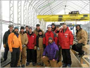
“DISCussion” —Members of SSEC’sIce Coring and Drilling Services (ICDS) have been in Greenland testing the Deep Ice Sheet Coring (DISC) drill since April. A newsletter published for July 2006 by VECO Polar Resources, the National Science Foundation’s Arctic logistics coordinator, recently featured an interview with ICDS’s operations manager, Jay Johnson. Johnson reported that the season has gone well so far. He attributes their success to “the exceptional talent and dedication of everyone on the crew [in Greenland] and our technical support from back home.” The field test will give ICDS the opportunity to make any necessary modifications to the DISC drill before it goes to Antarctica for theWest Antarctic Ice Sheet (WAIS) divide ice core project.
This month, Russ Dengel (SSEC), creator of the PDA Animated Weather online service called the PAW, changed the data source for accumulated precipitation to provide more frequent updates. Prior to the switch, the product updated every hour. Now, the precipitation totals update every 15 minutes using data from the National Severe Storms Laboratory.
Also in July, two more Web sites added links to the PAW site.AbbreviationZ added PAW as an Academic and Science–Meteorology link.WxNation added PAW to its PDA/Mobile page.
Dengel also added a view of Jacksonville, Florida to the PAW in response to a user request. The user thanked Dengel for providing the service and for responding so quickly to his request. Another user, from East Lansing, MI, complemented the site: “Wow! Fabulous!”
Research publicity—A few articles published in late July included mention of a tropical cyclones study led by Jim Kossin (CIMSS). The study involves a reanalysis of hurricane trends using an improved satellite dataset. Some highly publicized recent studies indicate a connection between increased hurricane intensity and climate change. However, several researchers have expressed concerns about the quality and continuity of the satellite data record. Kossin has recreated the dataset to be more homogenous and will reanalyze the trends with this improved dataset. A story on NPR on July 27titled “Storm Power Not Tied to Warming, Scientists Say” refers to Kossin’s study. “Things may become clearer after a team at the University of Wisconsin re-analyzes satellite data from the 1980s,” the report stated. “That result is a year or more away.” A similar quote appeared on National Geographic’s Web site on July 28 as well as in Science’s Perspectives section also on July 28.
 |
|
Two products from the CIMSS Tropical Cyclones research team contributed to National Hurricane Center discussion of Hurricane Daniel.
|
Adding to Hurricane Daniel discussions —CIMSS’s Tropical Cyclones research teamdevelops techniques that help forecasters study hurricanes using satellite data. Recently two such products contributed to National Hurricane Center (NHC) discussions of Hurricane Daniel. On July 19, the NHC report included the team’s hurricane intensity estimates created using data from the Advanced Microwave Sounding Unit (AMSU). NHC reported: “A CIMSS AMSU estimate of 101 KT at 2100 UTC and ADT [provided] estimates of T5.7.” The Advanced Dvorak Technique (ADT) is another tool to assess hurricane intensity. On July 24, the NHC discussion included mention of the team’s ADT measurement. “The shear environment is currently not favorable for further development … based on UW-CIMSS guidance.”
Effects of climate change on Wisconsin—An article on the front page of Madison’s Capital Times on July 3 brought together several perspectives on the local effects of climate change. Reporter Anita Weier provided readers with a comprehensive picture of this debate. Weier quoted Scott Bachmeier(SSEC) in article: “The short answer is, it’s impossible to pin weather extremes on global warming.” While Weier mentioned a few recent related studies that showed a link between extreme local weather and global warming, she also included evidence for Bachmeier’s hesitation to support such a connection. “There is so much about the Earth and the atmosphere we don’t understand,” Bachmeier said in the article. Sanjay Limaye (SSEC) addressed some broader questions about the effects of global warming. In the article, Limaye explains that it is too early to say for certain that there is an increase in the strength and number of hurricanes and tornados. Weier also interviewed, among others, Ed Hopkins, the assistant state climatologist, and several individuals associated with the Department of Atmospheric and Oceanic Sciences. A picture of Bachmeier surrounded by computers displaying products from SSEC’s Data Center accompanied the article.
Winners of the Verner E. Suomi Scholarship—Each year CIMSS awards scholarships to a few high school seniors who have demonstrated outstanding abilities in the physical sciences. Winners of the Verner E. Suomi Scholarship receive $1,000 towards their freshman year expenses as well as a certificate of recognition. Rebecca Gilsdorf from Sheboygan Falls High School and Matthew Duerst from Boyceville High School received the 2006 scholarships. Gilsdorf plans to attend UW-Madison this fall. She hopes to double major in Engineering Physics and Mathematics. Duerst also plans to attend UW-Madison. He intends to major in Atmospheric and Oceanic Sciences.
Recognized by NASA— NASA recently added CIMSS’s Satellite Observations in Science Education (SOSE) Web site to its Earth Science Education Catalogue. The SOSE Web site provides educational resources and data collection tools to educate post-secondary students about various principles of remote sensing.
 |
|
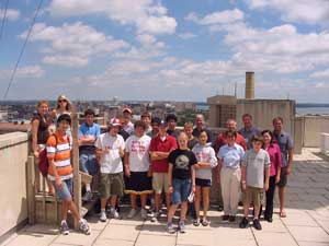
Fourteen high school students attend the CIMSS Summer Workshop on Atmospheric, Earth, and Space Sciences.
|
14th annual workshop for high school students—From July 23 to July 27, CIMSS hosted its 14th annualSummer Workshop on Atmospheric, Earth, and Space Sciences for High School Students. Fourteen students from across Wisconsin to Connecticut to Iceland stayed in UW-Madison dorms, and participated in an exciting series of interactive lectures, activities and field trips. The group traveled to the Milwaukee/Sullivan National Weather Service center where they learned about the facility and helped to prepare an imaginary severe weather alert. On the final day of the workshop, the students went to Devil’s Lake to learn about geology. Although the storm that soaked Madison on July 27 was not nearly as strong in the Devil’s Lake area, the group took the opportunity to discuss the threatening clouds that swept across the sky. Overall, the students gave the workshop a positive review.
|
|
|
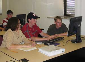
Kathy Strabala helped workshop participants practice using McIDAS.
|
Margaret Mooney orchestrated the workshop. Gary Wade (NOAA at SSEC), Jason Brunner (CIMSS), Matthew Lazzara (AMRC/SSEC), Steve Ackerman (CIMSS),Tony Wimmers (CIMSS), Howard Berger (CIMSS), Alex Harrington (CIMSS),Lynn Kjernes (CIMSS), Jen O’Leary (SSEC), and several McIDAS team members helped out by chaperoning field trips, and giving lectures and demonstrations.
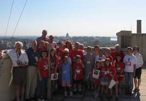 photo courtesy of Margaret Mooney photo courtesy of Margaret Mooney |
|
Eleven grandparents accompanied 14 grandkids in the meteorology major for Grandparents University.
|
Grandparents University—Each year UW provides the opportunity for UW alums to return to campus with their grandchildren. Participants inGrandparents Universitycan choose from a variety of “majors” hosted by different departments within the university. Margaret Mooney organized an exciting program for meteorology majors that drew 25 participants—11 grandparents and 14 grandkids. Matthew Lazzara (AMRC/SSEC), Jean Phillips (SSEC) and Jen O’Leary (SSEC) assisted with the activities and lectures.
 photo courtesy of Margaret Mooney photo courtesy of Margaret Mooney |
|
Several middle and high school teachers particpated in a workshop on satellite meteorolgy. These teachers came away with the tools to teach students about using satellite imagery to idenitfy environmental features and weather phenomena.
|
Educating educators—From June 26-28, several middle and high school teachers attended a workshop on satellite meteorology—one participant traveled to Madison from Micronesia. Margaret Mooney organized the workshop with hopes that the participants would gain the skills and tools necessary to help students learn how to use satellite imagery to identify environmental features and weather phenomena. Scott Lindstrom (SSEC), Howard Berger (CIMSS), Tommy Jasmin (CIMSS) and Tom Whittaker(CIMSS) contributed by offering lectures on satellite capabilities, interpreting satellite observations, research and education applications for satellite data and imagers, and satellite data educational software developed at CIMSS. Next year, Mooney plans to offer a similar course in remote sensing and global climate change.
Praise for outreach efforts— On the last Monday of every month, Steve Ackerman (CIMSS) and Jon Martin (AOS) answer questions about weather and climate as the Weather Guys on Larry Meiller’s show on Wisconsin Public Radio. On July 31, Karyl Rosenberg, a Wisconsin teacher, called in to complement CIMSS outreach efforts that target educators. Rosenberg mentioned that she attended CIMSS’s recent satellite meteorology workshop, which Margaret Mooney organizes, and found the material presented to be beneficial. She also praised the Wisconsin Weather Stories project, which resulted in a curriculum that uses a collection of local weather stories and meteorological data to help students learn about the weather. CIMSS will continue to develop much-appreciated tools to help teachers teach students about using satellites to observe the Earth.