Monthly News Summary – June 2006
Memorial Day traffic seen in satellite imagery
 |
|
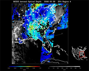
Satellite imagery from Memorial Day weekend shows areas of concentrated pollution over the interstate highways in the southeastern portion of the U.S. Click the image above to view a larger version.
|
“This is the first time I can remember such a strong signal,” said Tony Wimmers, lead researcher on the IDEAproject. Now run by SSEC, the Infusing satellite Data into Environmental Applications project, called IDEA, is a joint program with NASA, the Environmental Protection Agency, and NOAA. It uses data from the MODerate-resolution Imaging Spectroradiometer, or MODIS, to show areas of pollution. In this image, fuzzy blue areas show pollution–more precisely, fine particulate matter like that emitted by transportation sources–cars, buses, planes. In the image the streaky blue areas follow very closely the paths of interstate highways in the southeast U.S.
MODIS is an instrument on NASA’s polar-orbiting satellite that passes over the same spot on earth only twice daily; this is the only image available through SSEC’s Direct Broadcast facility for Memorial Day itself. In this case, the MODIS data tell the pollution story. White dots are EPA reporting sites, and are not included in the data for this image. Yellow and red areas show even heavier accumulation, which can occur suddenly from wildfires or slowly from urban and suburban areas generating pollution in stagnant air.
—Terri Gregory
 |
|
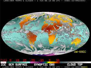
A new atmospheric science text book used one of the Data Center’s global montages.
|
Image in textbook —One of the Data Center’s staple global montages appeared in the second edition of Atmospheric Science: An Introductory Surveypublished by Academic Press. The montage is a composite of satellite imagery that shows sea surface temperature, land surface air temperature and clouds.
 |
|
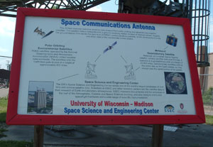
SSEC’s space communication antenna on Orchard Street now has an informative sign.
|
New sign for antenna—SSEC’s space communications antenna on Orchard Street now has a new sign that explains the antenna’s function. The antenna recieves data from both polar orbiting and geostationary weather satellites. The sign also provides information about SSEC.
 photo courtesy of ICDS DISC Drill Crew photo courtesy of ICDS DISC Drill Crew |
|
ICDS personnel are currently testing the DISC drill in Greenland. After testing in Greenland, the drill will return to Madison briefly before heading to Antarctica.
|
Drill ready to test—SSEC’sIce Coring and Drilling Services(ICDS) crew are in test mode at Summit, Greenland with their Deep Ice Sheet Coring (DISC) drill, designed to retrieve ice cores to depths of 4000 meters. According to ICDS program manager Don Lebar, “While depths approaching this have been cored before, the DISC drill makes use of state-of-the-art electronics and other innovations.” DISC engineering manager Alex Shturmakov praised the team for successfully completing the drill, the most advanced in the ICDS tool chest:
“Our electrical engineers made a tremendous accomplishment to get our electronics ready for the Greenland test. Our mechanical engineers worked hand-in-hand with our electrical engineers, helping them with last minute changes, modifying and machining brackets for electronics, helping to assemble parts, etc. Our last on-time scheduled shipment showed once again that not only do we have top-notch mechanical, electrical, and software engineers, but we also have an outstanding and cohesive team to drive this project to successful results.”
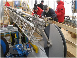 photo courtesy of ICDS DISC Drill Crew photo courtesy of ICDS DISC Drill Crew |
|
Once all of the drill parts had arrived in Greenland, the crew had to reassemble the drill.
|
Professor Kendrick Taylor, chief scientist on the WAIS Divide Ice Core Project for which the drill will be used first, gave thanks for “the hard work and long hours it has taken to pull this together.” Taylor and his coworkers at the Science Coordination Office also noted, “ICDS had to push very hard this spring to get it all built and tested, but they rose to the occasion and pulled it off.” Joan Fitzpatrick, Deputy Regional Director of the U.S. Geological Survey’s (USGS) office in Denver, congratulated ICDS on reaching the milestone of successfully completing the drill. The National Ice Core Laboratory, funded by the USGS, will work with ICDS during tests in Greenland. Congratulations also came from Professor Jeff Severinghaus of Scripps Institution of Oceanography. Hank Revercomb, SSEC director, congratulated ICDS “on a very exciting giant step toward extracting the next really important core for revealing our climate history.”
In late April, the first ICDS staff to arrive and set up for the summer-long testing period were Jay Johnson, Kristina Dahnert, Michael Jayred, Brent Folmer, and Ed Alexander. Johnson, an engineer, reported that staff had arrived by April 26, and began to set up in temperatures ranging from –40°C to +10°C and winds of from 5-35 knots. “All cargo arrived in excellent shape and without damage,” Johnson said. In the first weeks, the team installed the building electrical system and wired the transformer and voltage panel, and trenched cables that will power the drill and the rest of the facility. By May 7, ventilation systems and other supporting equipment were ready and a safety drill could be successfully performed.
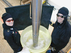 photo courtesy of ICDS DISC Drill Crew photo courtesy of ICDS DISC Drill Crew |
|
ICDS personnel began to arrive in Greenland at the end of April. Kristina Dahnert and Jay Johson are pictured above testing the drill’s pump motor.
|
It took the team until May 10 to power the drilling facility because they needed a part to overcome compatibility issues. The part, the main power distribution panel, arrived May 8 with a second group of ICDS personnel—Bill Mason, Nicolai Mortensen, Paul Sendelbach, Laurent Augustin, and John Robinson who helped with a variety of tasks to ready the camp and make it safe. Mid-May, the crew overcame problems keeping equipment warm enough to work (the gear boxes need to be kept at a constant temperature). Johnson and Mason, also an engineer, replaced the gear lube in the two small gear boxes with hydraulic fluid to work around the problem. Johnson said, “The small motors perform much better now and, under manual control, the winch is running well.”
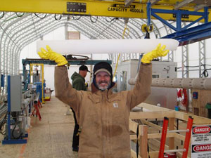 photo courtesy of ICDS DISC Drill Crew photo courtesy of ICDS DISC Drill Crew |
|
On June 1, the DISC team reached a major milestone. After many challenges, they obtained the first 100 cm of ice core. According to ICDS engineering manager Alex Shturmakov, “the core surface is very smooth and the core break was good.” Above, engineering Bill Mason victoriously holds the core.
|
The crew worked through myriad complications bound to occur in the cold and away from civilization. The crew not only set up its own fully equipped mechanical shop but also needed to set up housekeeping. On May 21, they hosted an open house for everyone on site, including other groups at Summit, and served goods they baked themselves. Johnson reported, “The DISC drill system is now completely assembled.” Please refer to theirweekly project updates to follow the team’s progress in Greenland.
ICDS drills are “modern marvels” —In March, a History Channel crew visited Madison to interview and film ICDS personnel and their drills for a Modern Marvels show on drilling. They also interviewed IceCube staff for whom ICDS had built the Enhanced Hot Water Drill, which, like the DISC drill, is state-of-the-art. The show was aired on May 8 and covered many kinds of drilling, delving into the history and mechanics of each. ICDS principal investigatorCharles Bentley and IceCube program manager and engineer Robert Paulos explained how the drills worked and what scientists expect to learn from each.
Building the DISC drill—The spring edition of the Physical Sciences Lab’s (PSL) Observer featured an article about the construction of ICDS’s DISC drill. The article focused primarily on the contributions of PSL engineers and instrument technicians. Two images of the drill and several ICDS employees accompanied the article.
Meetings and Field Experiments
Direct Readout Meeting —Users of NASA satellite data converged on Benevento, Italy in October 2005 to discuss mutual concerns. The Mediterranean Agency for Remote Sensing and Environmental Control hosted the meeting for users and providers of direct readout data at Villa dei Papi. The Earth Observer, newsletter of NASA’s EOS Project Science Office, featured the October 2005 meeting in its March-April 2006 issue. The article notes that the direct readout process, acquiring satellite data in real time, has been in use since 1983, when NASA’s Goddard Space Flight Center(GSFC) joined NOAA to set up a system to directly broadcast satellite data to any organization willing to invest in the technology, consisting of an X-band antenna and compatible ground receiving equipment. SSEC is a node in the Direct Broadcast system for MODIS data. Authors Patrick Coronado and Bob Kannenberg point out that a multiplicity of uses has grown along with awareness and accessibility of the system. Direct readout data is used to understand natural disasters, in environmental research, and in teaching, and is combined with other data to make more accurate forecasts of severe storms such as hurricanes. While proud of their achievements, participants wish to expand the utility and reach of direct readout data to more efficient uses and more remote areas.
SSEC’s Liam Gumley and Paolo Antonelli organized the October meeting with Coronado (GSFC), Maurizio di Bisceglie (University of Sannio), John Overton (National Polar-orbiting Operational Environmental Satellite System Integrated Program Office), and Darrell Robertson (NOAA’s National Environmental Satellite, Data and Information Service Direct Services Division). Also see GSFC’s Direct Readout site and the meeting write-up in In the News.
In May, the PDA Animated Weather service, known as the PAW, continued to receive positive attention. Both comments from users and the amount of traffic to the Web site illustrate the increasing popularity of the PAW. The site received over 228,000 hits in April—an average of about five hits per minute.
Russ Dengel (SSEC), creator of the PAW, gave a presentation about the service at the American Geophysical Union’s Joint Assembly in Baltimore, MD in late May. Jerrold Robaidek (SSEC) and SSEC Webmaster Bill Bellon contributed. The presentation included an overview of the PAW, several examples of the wide variety of applications and future improvements planned for the service. Dengel received only positive comments from presentation attendees.
Terri Gregory explained the service at the 53rd annual conference of the Society for Technical Communication held in May in Las Vegas. Gregory presented the service during a workshop session devoted to programs for handheld devices and demonstrated some of the service’s capabilities to enthusiastic cell phone users.
A very rainy spring—Scott Lindstrom (SSEC) appeared on Madison Channel 15’s 10 p.m. news for May 18. Lindstrom pointed out that while rain fell on Madison almost daily during the first portion of May, each shower generated only a few tenths of an inch of precipitation. In spite of the relatively small totals for each storm, the area has received more rain than usual. The broadcast included Lindstrom’s prediction that drier weather is in store for Madison.
Words on global warming—On April 21, Isthmus, a Madison weekly newspaper, ran an article about the microeconomic consequences of global warming. Reporter Erik Gunn centered the article around global warming’s effects on Wisconsin tourism and utilities. Sanjay Limaye (SSEC) provided information about the weather-related effects of climate change. Limaye noted that “one of the expectations is that we’ll have more extreme weather.”
Cyclone images—One of the CIMSS Tropical Cyclones group’s images of Hurricane Bret recently appeared on iCyclone, a Web site chronicling Josh Morgerman’s “hardcore hurricane chasing.” Mogerman used the image to accompany a reference to an NPR interview about his experiences chasing Bret. Morgerman also complemented Rick Kohrs’ (SSEC) “extremely cool Wilma satellite loop,” which can be found on the Tropical Cyclones group’sHurricane Wilma Web page.
Blogging about GIFTS—B and B, a blog out of Texas, covered the Geosynchronous Imaging Fourier Transform Spectrometer, or GIFTS, in an article on a recent National Research Council report. The report lists GIFTS as one of six vital earth science missions that NASA will not fund beyond this year. The blogger, a former astrophysicist, notes that GIFTS would measure spectral regions that cannot be easily measured from earth, regions rich in water vapor. He also mentions that an engineering model of the instrument is completed and that the World Meteorological Organization is leading a campaign to send GIFTS into space. SSEC is a partner on GIFTS with Utah’s Space Dynamics Lab and NASA’s Langley Research Center and is committed to the instrument’s completion.
MODIS research—SSEC researchers contributed to the development of the MODerate-resolution Imaging Spectroradiometer (MODIS) and continue to serve on science teams that monitor performance, suggest improvements, and develop data products for the instrument as it serves aboard NASA research satellites. Researchers presented latest developments at the January 2006 MODIS Science Team meeting. As reported in the Earth Observer newsletter (March-April 2006), Steve Ackerman, director of SSEC’s Cooperative Institute for Meteorological Satellite Studies (CIMSS), noted that “combining observations from different sensors improves confidence in radiance, provides insight to physical processes, and helps mitigate weaknesses of a particular instrument.” CIMSS is comparing products from MODIS with data from AIRS and MISR (instruments on the same satellites MODIS flies on) and ground-based instruments.
In the MODIS Calibration/Characterization Subgroup meeting,Chris Moeller (CIMSS) presented radiometric performance results of MODIS long-wave infrared carbon dioxide bands. He noted that these bands have shown out-of-spec radiometric behavior, and that some Aqua MODIS cloud-top pressure results are “qualitatively improved” by applying a radiometric bias based on AIRS and ER-2 comparisons to MODIS radiances. Early testing of Terra MODIS measurements suggests that it also benefits from applying a radiometric bias. Researchers are still considering why the radiometric bias apparently exists in MODIS.
“One Sky, Two Views” on WPR—On May 15, WPR aired a report about “One Sky, Two Views,” an innovative effort to integrate astronomy education with Native American culture. Reporter Brian Bull interviewed project coordinators Sanjay Limaye (SSEC), Patti Loew with UW-Madison’s Department of Agricultural Journalismand Rose Pertzborn (SSEC). Accompanying the WPR story, audio clips from a recent visit to the Milwaukee Indian School featured Loew telling a Native American star story as well as feedback on the session from participating children. Under funding from a Baldwin grant, “One Sky, Two Views” will also produce a textbook that targets middle school students. The WPR story provided listeners with an overview of the program and its significance. Native American culture is “a part of our heritage as a broader community,” said Pertzborn in the broadcast.
 |
|
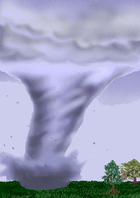
Tom Whittaker and Steve Ackerman developed the tornado applet. Click the image to create your own tornado.
|
Just like a game—Tom Whittaker, SSEC java guru and senior computer scientist, provided software for a Java applet he developed withSteve Ackerman, CIMSS director. A third grader doing an “independent research project about storms” found Whittaker’s tornado applet working on the internet with his father. Said the father, “Tornado twister is a great applet: realistic and intuitive–my son can quickly play with it at will without any help, just like a game software.” The tornado applet is the fourth main bulleted item on the Weather Wise page.
Polar winds work highlighted–NASA’s 2005 Earth-Sun Science and Data Highlights included a reference to Jeff Key’s (NOAA at SSEC) polar winds work under the heading “NASA/NOAA Make Major Weather Forecasting Advancements.” Key found that integrating data from the MODerate resolution Imaging Spectrometer (MODIS) into forecast models improved weather predictions. The note in NASA’s 2005 highlights also included a link to a story featuring Key’s work from NASA’s online newsletter, Earth Observatory.