Monthly News Summary – April 2002
Winter Finally Arrives in Wisconsin
by Terri Gregory, SSEC Public Information Coordinator
This issue of In the News covers news and events mostly occurring in March 2002. Use images freely with credit to the Space Science and Engineering Center, University of Wisconsin–Madison.
Cold Canadian winds blew an incipient spring out of the Midwestern United States on Saturday, March 2. The winds also blew away a facile comparison of this winter with last year’s. Until March, one could easily say that winter 2000-2001 (last year) was snowy and cold.
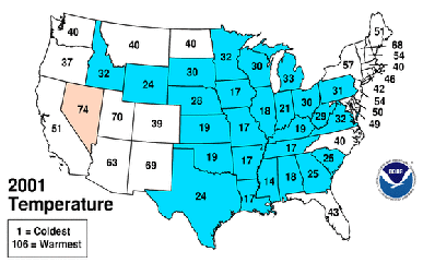 |
The top graphic ranks each state on precipitation received for all last winter, based on records for each state. Midwestern states mostly received at least a normal amount of precipitation, including snow. The bottom graphic ranks states on temperature. Most of the central U.S. was colder than normal. Click on each for more information.(Maps by NOAA) |
Winter 2001–2002 (this year) was mostly not snowy and was warmer than average.
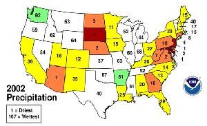 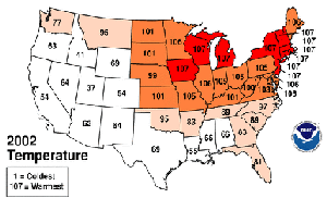 |
These graphics correspond with those above, for this past winter, 2001–2002. This winter was much dryer and warmer than last year. Click on each for more information. (Maps by NOAA) |
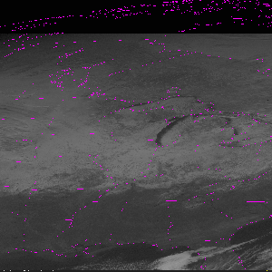  |
Both images are visible images taken by the GOES-East satellite. The top image was taken on December 22, 2000. The white area over the northern Midwest is snow. The bottom image was taken on December 20, 2001. Most white areas over the northern Midwest is cloud. For the most part, this image is snowless. Click on each for a larger view. (Images by J.Robaidek and SSEC Data Center) |
Last October, NOAA climate forecasters predicted that the Midwestern U.S. would probably have a “normal” winter—cold with lots of snow.
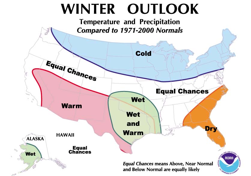 |
Forecast for this winter (December–February) 2001–2002. Click for a larger vesion. (NOAA) |
The cold really did not arrive until the beginning of March, when places like La Crosse and Madison, Wisconsin finally recorded their first below zero° F temperatures of the entire winter season. Periodic snowfall did cover parts of the region from December through February, but the distribution of snow pack was very spotty compared to a normal winter (when a widespread snow cover is usually in place across most of the Great Plains and Midwest region north of 40° N).
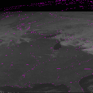
CIMSS meteorologist Scott Bachmeier showed the extent of snow cover after the January 30–31, 2002 storm in this GOES satellite image, which shows how spotty snowfall was. The heavy diagonal swath is the only snow in those states.
According to Bachmeier, “a map of current snow depth [the end of February 2002] produced by the Meteorological Service of Canada (MSC) shows how much farther north the existing snow pack was in relation to the climatological ‘normal’ for this time of year (the dashed line on the map represents the normal 1-cm snow depth line).”

Bachmeier noted that in December 2000, Iowa had record-setting snow depths (20-30 inches) across much of the state (top graphic). In December 2001, only the upper peninsula of Michigan had anything resembling normal snow cover (bottom graphic).
 |
These graphics show inches of snow on the ground. In December 2000 (top), a large area of snow cover had 6-18″ (light and dark green) on the ground, and some areas had as much as 18-30″ (blue). Click on each for more information.In December 2001 (bottom), however, most of these northern Midwest states had received 6″ or less of snow. (Maps by NOAA’s North Central River Forecast Center in Minnesota) |
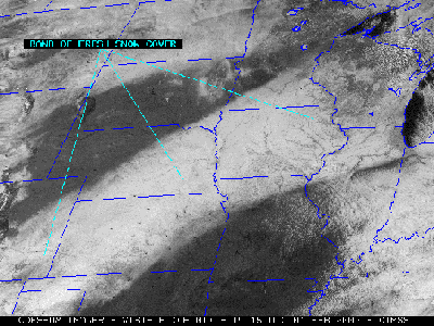
Then March came in “like a lion,” breaking records for cold and snow throughout the Great Plains states and the Midwest. One example was the heavy snow which fell across much of the north central U.S. from March 13–15 (the red-enhanced swath across Wyoming, Nebraska, South Dakota, Minnesota, Wisconsin and Michigan on this MODIS composite image from NASA’s Terra satellite).
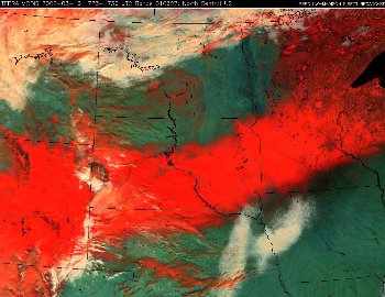 |
Red shows a swathe of snow freshly fallen across the Midwest. (Liam Gumley) |
Storm total accumulations were as high as 19 inches in South Dakota, 21 inches in Minnesota, and 20 inches in Wisconsin. By mid-March, Marquette, Michigan had gone on record with its greatest amount of seasonal snow ever–300 inches this winter. The storm brought not only heavy snow, but frigid cold uncharacteristic of March. Temperatures plummeted to -27° F in parts of Montana, with the following week averaging about 30° F below normal for that time of year. For many locations across the Great Plains and Midwest region, March was, after all, fairly snowy and much colder than normal, partially offsetting the record warmth and low snow of the early months of this winter.
Antarctica
New icebergs—Matthew Lazzara, co-investigator of SSEC’s Antarctic Meteorological Research Center, appeared on WORT-FM, the Madison area’s public access radio station, on its local evening news show, “In Your Backyard.” The topic was a stretch for local news—Lazzara discussed Antarctica’s icebergs, which he monitors with satellite imagery, including the recent Larsen Ice Shelf breakup. The show aired March 20.
Team Encounter, a Web site for a private satellite company, uses the Antarctic composite in an explanation of orbits most suitable for solar sail technology.
Field Programs
IHOP-2002—SSEC and CIMSS will support the International H20 Project experiment this spring, planned to better measure humidity, rainfall and overall moisture in the air. The National Center for Atmospheric Research, the lead organization, hopes “that the IHOP-2002 measurements will ultimately help us in understanding when, where and how storms form and will allow us to better predict actual rainfall amounts associated with these storms.” From May 13 to June 30, 2002, scientists from agencies and universities in the U.S., Canada and Europe will study the weather in the Southern Great Plains states of Kansas, Oklahoma, eastern Colorado and the Texas panhandle. SSEC will take its AERIBAGO, a Winnebago converted to carry instruments, to the Oklahoma panhandle, and will fly two instruments from Oklahoma City. SSEC’s Scanning-High resolution Interferometer Sounder will fly on a DC-8 outfitted for research, and will participate in flying the NPOES Atmospheric Sounder Testbed-Interferometer on the Proteus high-altitude research aircraft. SSEC will also provide some satellite products (GOES and MODIS) as well as numerical weather prediction support. Weather instruments already located in the target states will be extensively used during the experiment.
THORPEX—Planning is underway for THe Observing system Research and Prediction EXperiment, a worldwide grand-scale weather experiment hoped to take place over the next decade or so. THORPEX is planned to be a “ten-year international research program to accelerate improvements in short-range (up to 3 days) and medium-range (3 to 10 days) … predictions and warnings of high-impact weather over the Northern Hemisphere.” Like the World Weather Experiment (aka FGGE) in 1978, THORPEX will utilize technologies and strategies being developed during the planning period. SSEC’s CIMSS will participate in THORPEX planning, which will include shorter regional programs, including one over the Pacific Ocean in the winter of 2003, followed by one over the Atlantic in 2004. Agencies from around the world, including many in the U.S. and Europe, are involved. The ambitious program will pursue several goals, among them identifying geographical regions where new permanent observing systems would most greatly improve Northern Hemispheric forecasts. Another THORPEX goal is developing improved strategies for targeting in-situ and satellite observing systems. A special focus will be on cloudy regions where a greater vertical resolution is needed.
To prepare for THORPEX, the National Centers for Environmental Prediction (NCEP) and its collaborators are designing an Observing System Simulation Experiment to estimate the impact of lidar wind profiles on numerical weather prediction. As part of this experiment, CIMSS and NOAA/NESDIS researchers will give input and statistical analysis for simulated cloud-track and water vapor wind measurements. THORPEX is a project of the World Meteorological Organization, within its World Weather Research Programme (WWRP) and within the US Weather Research Program.
Neutrino Science
IceCube approved—On March 15, Wisconsin Representatives David Obey and Tammy Baldwin announced that the National Science Foundation had approved release of $15 million to begin IceCube, a far-reaching neutrino telescope at the South Pole. Researchers at the University of Wisconsin-Madison collaborated with researchers around the world in the prototype telescope, AMANDA. In IceCube, the field of view is expanded to a one kilometer cube in which detectors are set into the ice in strings. The newly released funds will enable UW-Madison’s SSEC to begin work on a massive hot water drill to make holes a kilometer deep. When a Senate Committee recommended funding of IceCube, they said, “Continued development is expected to lead to a new era in astronomy in which scientists will have unique opportunities to analyze some of the most distant and significant events in the formation and evolution of the universe.” National Public Radio’s Weekend Edition noted on March 16 in its state segment that IceCube had been approved. Ernie Mastroianni, writing in the Milwaukee Journal Sentinel for April 1, stressed the size and complexity of the project.
The Solar System
Neptune—Two proposals from UW–Madison scientists to use the Hubble Space Telescope were accepted out of 15 submitted from Wisconsin in the current observing round, Cycle 11. One proposal is Lawrence Sromovsky’s (SSEC) on Dynamics and Cloud Structure of Neptune. The other (by Linda Sparkes, Department of Astronomy) uses archived data. Sromovsky and his co-investigators Kevin Baines (JPL) and Sanjay Limaye (SSEC) will observe with the Wide Field Planetary Camera on the Hubble Space Telescope to view Neptune in 2002. They also propose to use IRTF and Keck ground-based telescopes to “enhance the characterization of cloud structure,” as they’ve done in other years. Sromovsky’s team observed Neptune with the Space Telescope and ground-based telescopes in 1996 and 1998. This year, they’ll make detailed comparisons with earlier observations using the same filters they’ve used before.
Over the years, Sromovsky and his co-investigators have studied not only the dynamism of Neptune, arguably the windiest and most active in our solar system; they’ve studied its cloud structure, including several discrete features. Some are visible every year they look, some disappear in the intervening years. A Great Dark Spot, an earth-sized storm in Neptune’s southern hemisphere that drifted toward the equator with a bright companion cloud, was first seen in Voyager 2 images in 1989. By 1994, that storm had disappeared and a new Great Dark Spot had appeared in the northern hemisphere. By the time Sromovsky and his group observed in 1996, a new Great Dark Spot, without companion clouds, had formed further south in the northern hemisphere. In 1998, both dark spots had disappeared, but the northern hemisphere had become much brighter. The scientists look forward to new features in 2002 and what they signify for the general circulation. Sromovsky hopes to “add to the circulation data base for Neptune and contribute to an understanding of its origin, maintenance, and time-dependent behavior.” He also notes, “Neptune’s dynamics and cloud structure are worth studying because they exhibit many unusual features not seen in any other atmosphere, and because understanding these features may contribute towards an understanding of what controls the style of outer planet circulations.” The Space Telescope Science Institute’s Newsletter, Winter 2002, reports that 1078 proposals were submitted to use the Hubble Space Telescope. 198 were approved
The image of Neptune produced by Larry Sromovsky with Pat Fry in 1998 appears on the dust jacket of the recent National Geographic book, Exploring the Solar System: Other Worlds, by J. Kelly Beatty. Beatty is executive editor of Sky & Telescope magazine. In Other Worlds, he takes his audience on an illustrated tour of our solar system and the history of its exploration, from the ground and by space probes.
Weather Guys
Weather Guys—Steve Ackerman (CIMSS, AOS) and Jonathan Martin (AOS) appeared on Larry Meiller’s WHA Radio call-in show on Monday, March 25 in their regular last Monday time spot. The show proceeded normally with many questions on Wisconsin’s spring weather, until a young caller asked, “what are sundogs and where are they playing?” Martin, a meteorology professor during the day and a band member of Sun Dogs after hours, insists young Henry’s call was not a set up. The band plays occasionally in local night spots. Ackerman explained that sun dogs are pillars or spots of light on either side of the sun, like reversed rainbows. The Guys appear again on Monday, April 29 at 11:45 to 12:30 on 970 AM, 90.7 FM, or on the Internet. Click on Live Ideas Network Webcast.
Meteorology—A stunning new addition to atmospheric science learning tools,Meteorology—Understanding the Atmosphere by Steven Ackerman and John Knox, has just been published by Brooks Cole-Thompson Learning, Pacific Grove, CA. Although the book has a copyright of 2003, it is available now at Amazon.com. According to Amazon’s review, “The authors’ lucid writing style captures students’ interest, and the integration of high-magnitude, real-world weather events to illustrate the impact of the weather, communicates the authors’ enthusiasm and love of the subject.” It’s better than that. This reader had a hard time putting it down. Psychological studies show that vivid detail is better remembered. If that’s true, you’ll never forget “Extratropical Cyclones and Anticyclones,” which includes the gripping tale of the ore ship Edmund Fitzgerald, which sank in a deadly storm on Lake Superior in 1975. The account of sailors lost at sea made the book the first and probably the last textbook ever to make me cry. That aside, the textbook succeeds because the authors poured into it their combined knowledge of how students learn, gained from years of teaching and research in the atmospheric sciences at the University of Wisconsin–Madison and the University of Georgia. As they do in their courses, Ackerman and Knox include real-world exercises and interactivity in lessons ending each chapter. A CD is included to help connect to the Web. Many satellite images are included to show the weather as it happened for a particular event, and the graphics, even where they include mathematics, are understandable by an intelligent college student or interested lay person. This is a textbook you would want for yourself.
Weather Research
Wind measurements derived from MODIS satellite data and provided to the European Centre for Medium Range Weather Forecasting (ECMWF) demonstrated a positive impact on short-range weather forecasts over the Arctic. N. Bormann of the ECMWF reported a fairly large forecast improvement for the northern hemisphere, particularly over the North Pole. The southern hemisphere (Antarctica) is neutral to slightly negative in this case study, which may be due to errors in the model “first guess” used in the retrieval. The wind measurements affect positively the mean wind analysis for both poles. Jeff Key (leader of the NOAA team at SSEC) and Chris Velden and Dave Santek (SSEC/CIMSS) work on the polar winds project.
Researchers studying Earth’s polar regions have submitted three papers to the International Geoscience and Remote Sensing Symposium to be held in Toronto in June. A paper by M. Pavolonis (CIMSS) and J. Key (NOAA) describes the effects of clouds on the surface radiation budget of Antarctica. Y. Liu (CIMSS) and J. Key present a method for detecting low-level temperature inversions in the polar regions with MODIS data. X. Wang (CIMSS) and J. Key evaluate trends in Arctic cloud and surface properties over the past 20 years using the AVHRR Polar Pathfinder data set.
Researchers who use GOES data to monitor biomass burning (including forest fires) have submitted four abstracts to the spring American Geophysical Union meeting this May. Elaine Prins (NOAA, stationed at SSEC) and Joleen Feltz and Chris Schmidt (CIMSS) submitted papers including an overview of the GOES Wildfire Automated Biomass Burning Algorithm (WF-ABBA) processing system, case study comparisons of GOES WF-ABBA fire observations and downwind carbon monoxide values derived from the Measurements Of Pollution In The Troposphere (MOPITT) instrument on the Terra satellite, and measurements of aerosol optical thickness derived from GOES-8 data in North and South America compared with ground truth sun photometer data. The group also was invited to speak on recent GOES fire monitoring activities and applications in the Western Hemisphere.
A heavy snow event over the north central portion of the United States on March 14, 2002 provided the opportunity for CIMSS researchers to compare water vapor imagery from the Moderate-resolution Imaging Spectroradiometer (MODIS) instrument on NASA’s polar-orbiting earth science satellite with that from GOES-8 and GOES-10. Snow accumulations were as high as 19 inches in South Dakota, 21 inches in Minnesota, and 20 inches in Wisconsin. CIMSS researchers Scott Bachmeier and Mat Gunshor found that the higher spatial resolution of the MODIS water vapor channel data (1 km, versus 4 x 8 km for GOES imagers) allowed better detection of the axis of a jet streak feature crossing the Kansas/Nebraska border. Brightness temperatures were generally 2-6° C warmer across this scene on the MODIS data (especially in the region of the dry slot associated with the axis of the jet streak), since the weighting function peaks lower in the atmosphere for the MODIS water vapor channel than it does for the GOES-08/GOES-10 water vapor channel. The more extreme viewing angle from GOES (zenith angles near 50 degrees) also contributes to the colder brightness temperatures compared to MODIS.
A model that predicts crop yield is featured in Science Report, 2002-2003 by UW–Madison’s College of Agriculture and Life Sciences. The Precision Agricultural Landscape Modeling System or PALMS is developed by SSEC’s George Diak and Christine Molling and a team of soil scientists led by John Norman. As noted in the report, the model, which works on a high-speed desktop computer, tells “how the corn is growing in a field, and what its yield and grain moisture will be.” The model predicts variability across a field, in 20 foot by 20 foot chunks. The model correctly predicted that corn would die in certain sections of an Arlington, Wisconsin test field after long and heavy rains in spring of 2000.
Tropical Cyclones—Max Mayfield, director of the Tropical Prediction Center (formerly the National Hurricane Center) will use satellite imagery provided by CIMSS’ Tropical Cyclones Group in hurricane preparedness talks. Director Mayfield said that the “high quality satellite animations” will be shown wherever he travels along the U.S. Gulf and Atlantic coasts and throughout the Caribbean. The imagery also would be shown to 2000 attendees of the Interdepartmental Hurricane Conference, held mid-March in New Orleans and at the Caribbean Hurricane Awareness Tour later in March. The imagery covers selected tropical storms and hurricanes from last season.
Recent publications by SSEC scientists
Honors
 Award for Excellence—Senior scientist Wilton Sanders has been awarded this year’s Chancellor’s Award for Excellence in Service to the University. Sanders is an astrophysicist who has spent his professional career as an academic staff scientist in the University of Wisconsin–Madison in both the Department of Physics and the Space Science and Engineering Center. He is one of four academic staff to receive a Chancellor’s Award, the only one for university service. SSEC’s releasegives details on his many years of research and service.
Johnson Award—CIMSS scientist Jun Li received the NOAA David Johnson Award in Washington, DC on March 22. The award is presented annually to a young scientist for “outstanding innovative use of Earth observation satellite data.” NOAA and the National Space Club awarded Jun Li for “his exceptional and unique contributions to the development of sounding retrieval algorithms for the nation’s civil operational geostationary and polar-orbiting environmental satellites and leadership in defining the high-spectral resolution sounders for the next generation of satellites.”
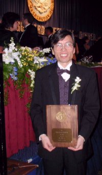 Jun Li receives the NOAA Johnson award.
A release from NOAA’s National Environmental Satellite, Data, and Information Service adds that “in his five years as CIMSS researcher, Li has demonstrated that data from infrared instruments combined with data from microwave instruments provides more data about the atmosphere than was possible from either type of instrument alone. This has resulted in greater knowledge about the atmosphere and improvements in weather forecasting. Li’s approach to classifying clouds has minimized the reliance on troublesome threshold techniques and is improving the capability for reliable global cloud detection with a single algorithm.” Li credits his colleagues for the award, especially CIMSS’ GOES and MODIS groups. The award honors the first administrator of what was to become NOAA/NESDIS. Editor Madelyn Appelbaum will include the award in NOAA’s online employee newsletter, Access NOAA, in its April issue.
In Passing
Commenting on an article in On Wisconsin, Winter 2000, UW alum Howard Wagner remembered a student job he held in 1960. He edited weather data received via satellite for a project of Professor Verner Suomi (SSEC founding director). Wagner noted how excited students were “when they discovered they could correlate the satellite data … with the weather observations at ground stations.”
Meetings
The annual meeting of the Antarctic Automatic Weather Station (AWS) program and the Antarctic Meteorological Research Center (AMRC) will be held May 21 and 22 at Madison’s Howard Johnson Hotel near the UW–Madison campus. Participants will discuss AWS field seasons, AWS on icebergs and iceberg monitoring by the AMRC, the new AWS system, Antarctic climatology using AMRC’s satellite image composites, future plans for Antarctic research. Polar researchers will attend from around the world, especially from many U.S. agencies and universities. A link to meeting information is on the AMRC main page toward the bottom.
Outreach
SSEC Outreach—As part of an outreach series with area Girl Scouts, SSEC’s Margaret Mooney coordinated a program Saturday, March 16 at UW–Madison’s Pyle Center. About thirty 30 girl scouts attended the program that began with a videoconference from NASA’s Langley Research Center in Virginia. Bill Smith, chief atmospheric scientist at Langley, spoke about severe weather and the use of satellites in tracking it. After Smith’s talk, the girl scouts built weather instruments, including a barometer and an anemometer. According to a Girl Scout news release, “This program in science is just another example of how Girls Scouts is providing girls enriching opportunities to have new experiences and learn.” Madison’s TV channel 15 (WMTV) covered the event that evening, and, according to Margaret Mooney, relayed the partnership between SSEC, NASA and the Girl Scouts. Two girls from Troop 949 were interviewed and featured. Before joining SSEC, Mooney spent 15 years with the National Weather Service.
WAA—As noted in the Capital Times newspaper for March 9–10, the Wisconsin Alumni Association maintains an active travel program for university alumni. This year, one tour caters to astronomy and earth science buffs. In April, astronomer Jim Lattis (UW Space Place director) and planetary scientist Sanjay Limaye (SSEC outreach director) take two dozen travelers to Arizona’s astronomical hot spots—the WIYN telescope on Kitt Peak, the U.S. Geological Survey and Sunset and Barringer Meteor Craters in Flagstaff, the Lowell Observatory, the University of Arizona in Tucson. The group will visit some of Arizona’s most beautiful places, too—Sedona, the Grand Canyon, the Verde River canyon by rail, and Scottsdale. You can find more information on the WAA Web site. uwalumni.com/travel. UW-Madison’s quarterly magazine, On Wisconsin, mentioned the tour also.