Monthly News Summary – April 2001
Light Shown on Neptune’s Clouds
by Terri Gregory, SSEC Public Information Coordinator
April 2001
This issue of In the News covers news received primarily in March 2001. Please feel free to use images, with attribution to the Space Science and Engineering Center, University of Wisconsin–Madison (SSEC/UW–Madison), except where otherwise noted.
Icarus–The February 2001 issue of this, theInternational Journal of Solar System Studies,has published three papers on the imaging of Neptune and its moon Triton by SSEC scientist Larry Sromovsky and others. The papers are the culmination of five years of observing atmospheric conditions on Neptune with ground-based telescopes and the Hubble Space Telescope (HST). Sromovsky and his colleagues from SSEC (Pat Fry and Sanjay Limaye), Kevin Baines of the Jet Propulsion Laboratory, and Tim Dowling of the University of Louisville’s Comparative Planetology Laboratory, used the HST Wide Field Planetary Camera 2 and NASA’s Infrared Telescope Facility in Hawaii to analyze cloud structures on Neptune. The HST camera provided the greatest horizontal resolution of cloud features and motions, while the IRTF 1-5 micron camera provided the best vertical resolution of cloud structure using deep absorption bands of methane and hydrogen.
The group “developed very precise navigation techniques” to collocate nearly simultaneous observations from the different telescopes and a novel differential deconvolution technique that yielded by far the most detailed ground-based images of Neptune yet obtained without speckle imaging or adaptive optics.
The group discovered a new earth-sized dark spot on Neptune, tracked the decline of the first northern dark spot discovered in 1994, showed that Neptune’s circulation has been stable since 1989, identified new planetary wave structures, defined the altitudes of discrete bright cloud features, explained spectral variations in Neptune’s brightness in terms of varying amounts of high altitude clouds, and established that the deep clouds of Neptune are either absent or are composed of extremely dark particles for which no candidate composition is currently available. These preliminary results will be augmented by further analyses to explain the cloud bands of Neptune and the unusual dynamics of its Great Dark Spots. (Funded by NASA)
Iceberg B-15A Visited
For More Information
BBC News Online—Researcher Jonathan Thom, SSEC, and glaciologist Douglas MacAyeal, University of Chicago, placed Automatic Weather Stations on iceberg B-15A in January. The iceberg is about half of a Connecticut-sized berg that calved from the Ross Ice Shelf in March 2000. The National Science Foundation sent a video crew with the research team to videotape placement of the equipment, which includes instrumentation to measure wind velocity and direction, relative humidity, surface temperature and barometric pressure. With the measurements collected on the iceberg, scientists will analyze the “iceberg’s motion and effects of collisions” with the shoreline.(Funding by NSF)
Science and Technology News Network’s Joyce Gramza used NSF videotape to produce their own, with Douglas MacAyeal, principal investigator of the iceberg mission, and Jonathan Thom, SSEC researcher, shown placing equipment in the ice. MacAyeal explains the purpose of the mission.
Learning Network—In “Icebergs Ahoy,” Holly Hartman gives facts, figures, and background of icebergs, starting with B-15, in terms that middle school children can understand. For pictures of the B-series and other icebergs, she links back to the AMRC Web site on icebergs.
LATimes.com emphasizes global warming and its possible connection with a seeming avalanche of new icebergs. “Many scientists believe that the changes they see in the world’s ice are the first symptoms of global warming… .” The writer notes that “global warming is far from an established phenomenon.“ He then notes that ice is retreating and thinning everywhere in the world.
Associated Press—Ernest Mastroianni’s recent Antarctica series in the Milwaukee Journal Sentinel emphasized the work of UW–Madison’s researchers. A summary was published on January 8 in these Wisconsin newspapers: Portage Daily Register,Marinette EagleHerald, The Waukesha Freeman and The Racine Journal Times.The original Mastroianni series ran from the beginning to the middle of January. The researchers with SSEC connections who are mentioned in the AP summary are Charles Stearns (Automatic Weather Stations), Charles Bentley and SSEC’s Ice Coring and Drilling Services, and Francis Halzen and Robert Morse of AMANDA (Antarctic Muon and Neutrino Detector Array). Funding for all these projects is provided by the National Science Foundation, which is the major source of funding for research in and about Antarctica.
Weather Research
For More Information
Recharacterization of Ice Particles—Jeff Key (NOAA) and his SSEC colleagues have recharacterized the shortwave optical properties of various ice particle “habits” for use in a radiative transfer model. It is now possible to simulate the effects of ice cloud particle shapes and sizes on satellite observations. Particle habits include hollow and solid columns, aggregates, plates, bullet rosettes, and dendrites.
Brightness Temperature Comparisons—Gail Bayler (SSEC) and Tim Schmit (NOAA) have provided information for two comparison studies for the University of Maryland and the Jet Propulsion Laboratory (JPL). They compared brightness temperature (surface radiation) measurements from the GOES sounding instrument with those from collocated radiosondes (weather balloons) for several months. R. G. Ellingson and M. Ba, U. of Maryland, are using the differences between the two measurement methods to adjust the GOES channel radiance by adding the difference. This improves the comparisons of their GOES Outgoing Longwave Radiation products with the Clouds and the Earth’s Radiant Energy System product.
Schmit and Bayler also provided GOES data to JPL’s S. Hook to improve the atmospheric correction for MODerate Resolution Imaging Spectroradiometer (MODIS) skin (earth’s surface) temperature calculations. GOES-10 Sounder profiles were produced for the area over Lake Tahoe for seven days in 2000. GOES-10 Imager brightness temperatures were also provided for two days (one windy and one calm) and are being compared to collocated ground truth on Lake Tahoe.
Fire products—Elaine Prins (NOAA) and her CIMSS colleagues provided GOES fire products to S. Feitas of NASA’s Ames Research Center. The University of Sao Paulo and NASA Ames have developed a physical model of source emissions based on fire products from previous years. They are validating their approach using field observations taken during the 1999 dry season (September and October) using the GOES Automated Biomass Burning Algorithm (ABBA) developed by the NOAA-SSEC team at the University of Wisconsin–Madison. Preliminary aerosol measurements have shown very good agreement with the aerosol index from the Total Ozone Mapping Spectrometer.
ABBA fire products are being used as an indicator of land-use and land-cover change and carbon dynamics in Western Amazonia along the borders between Brazil, Peru, and Bolivia. As part of an international collaboration with universities, research institutes, and government planning agencies, a recent summary of this multi-year effort “indicates the usefulness of GOES ABBA fire products as a near real-time source of land-use information for monitoring large areas and an excellent broad brush tool for land use patterns.” As an example, Foster Brown of the Universidade Federal do Acre, Brazil recently used GOES ABBA results from the 1998 fire season to verify that the Chico Mendes Extractive Reserve serves as a barrier to expanding deforestation and anthropogenic fire activity in Western Amazonia. Local validation studies during the past three years indicate that the GOES ABBA fire product generated every three hours underestimates the actual fire activity. Half-hourly GOES Wildfire ABBA fire products will be used during the 2001 fire season to increase diurnal coverage and capture short-lived fires.
 |
Click on the excerpted image for an image and caption showing burning around the reserve. |
The Biomass Burning Monitoring group is also providing fire products to NOAA’s Satellite Services Division for National Hazard Information Strategy activities. The Wild Fire ABBA fire products, made from GOES data, are retrieved every half-hour (near-real time) via anonymous FTP. The fire products contain GOES-derived fire locations and ancillary information for the entire Western Hemisphere.
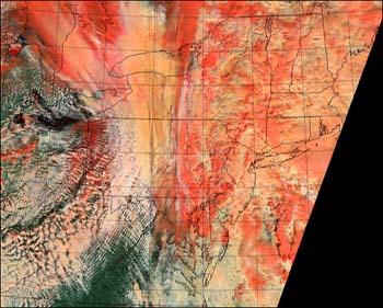
Simulating Satellite Imagery—A team of SSEC-based NOAA employees are collaborating with CIMSS and SSEC researchers to simulate imagery of future satellite instruments. The team, including Tim Schmit and Elaine Prins of NOAA’s Advanced Satellite Products Team; Scott Bachmeier, Gail Bayler, Mat Gunshor, Jim Nelson, Suzanne Wetzel of SSEC’s CIMSS, and SSEC’s Dave Santek, used MODIS data to simulate imagery from the future Advanced Baseline Imager (ABI) and from the GOES-I/M imager to show a range of phenomena. They applied a set of Point Spread Functions to simulate instrument-blurring effects. NOAA hopes to use the generated image sets to demonstrate the improved capabilities of the ABI.
The team has gone on to simulate combined ice, snow and clouds as seen by the ABI. Bryan Baum (NASA scientist from Langley Research Center stationed at SSEC) aided the team in simulating an ABI scene over the Great Lakes region using a combination of MODIS visible (.64 micron wavelength) and 1.6, 8.5, and 11 micron data.
 |
Click on the excerpted image for the larger image. The scene, taken at 16:27 UTC on February 12, 2001, contains snow, lake ice, ice clouds, and water clouds, including super-cooled water clouds. A 3-color composite (visible, 1.6, and 8.5 minus 11 micron bands) clearly identifies these similar features which are not as readily distinguished using the current GOES capabilities. |
Fog and Stratus—Scott Bachmeier (SSEC/CIMSS) and Tim Schmit (NOAA) compared multiple fog and stratus cloud features over the northern U.S. plains using infrared imagery and fog/stratus products from both the GOES imager and Terra’s MODIS instrument. The higher spatial resolution and better signal-to-noise ratio of the MODIS IR data allowed better detail to be shown, especially the location of fog and stratus edges and the formation of narrow river valley fog features.
TX2001—The Texas MODIS Experiment 2001 was conducted from Kelly AFB near San Antonio, Texas from March 14 to April 4 to improve calibration of the MODerate resolution Imaging Spectroradiometer. MODIS flies on NASA’s Terra satellite, launched in late 1999. SSEC’s Scanning High Resolution Interferometer Sounder (S-HIS) flew on NASA’s high-altitude aircraft, the ER-2, with the 50 channel MODIS Airborne Simulator (MAS), an instrument SSEC’s Cooperative Institute for Meteorological Satellite Studies helped develop.
Errata—In the March 2001 In the News column, SSEC’s Dave Santek should have been included as a developer of the wind derivation computer code in the top Weather Research item. It is important to include as many contributors to every team endeavor as we can identify.
University Communications
For More Information
Wisconsin Week and Wisconsin Week Wire, March 21, Terry Devitt—The AMANDA telescope is the “first instrument to detect and track high energy neutrinos.” reported in the journal Nature. According to principal investigator physicist Robert Morse, AMANDA, stationed in the South Pole, points down to look through the earth for neutrinos entering at the North Pole. Glass sensors (photomultiplier tubes) buried in the ice act as light bulbs in reverse, capturing faint streaks of light caused by a neutrino very occasionally colliding with another subatomic particle like a proton. The paper inNature establishes that the telescope can detect neutrinos. The cosmic neutrinos physicists seek are so rare that only one neutrino has been detected, and that since the paper was published. SSEC administers AMANDA and other Antarctic astronomy and astrophysics projects.
On the Net
For More Information
River Delta
Earth Observatory—The Mississippi River delta and its sediment plume are shown in true color in an image captured by the Moderate-resolution Imaging Spectroradiometer on NASA’s Terra earth science satellite on March 15. The image, produced by SSEC’s Liam Gumley, shows the river’s muddy waters mixing into the dark blue Gulf of Mexico.
On March 5, MODIS imaged a severe nor’easter over the northeastern U.S. including New England. Liam Gumley’s false-color composite image colors snow red to distinguish it from the white clouds. The MODIS capability to “see” in near infrared wavelengths makes it easy to show the difference.(Funding by NASA)
 |
Click on the small image for the large one and its caption. |
Imagesbigchalk.com—This Web site “offers award-winning research products, teacher resources, homework help, online field trips, standards information, easy school Web site creation tools and more.” bigchalk gives “awards” to those Web sites they believe to be “in the top 2% based on your rich content and its academic relevance.” The GOES-8 snapshots that SSEC serves for NOAA are listed under Satellite Images.
In Print
For More InformationEncyclopedia of Global Environmental Change, John Wiley and Sons—In her review of tropical storms in this encyclopedia, J. Evans, Pennsylvania State University, will use the montage display of Hurricane Georges. Gary Wade (NOAA) assembled the montage from daily Geostationary Operational Environmental Satellite (GOES) infrared images taken in September 1998. Evans commented that “this figure … provides a wonderful summary image for nonscientists to track the evolution of the hurricane core.”Metlink
Good Practice in the Use of ICT—The global montage from SSEC’s Real-time Data Web page is used in this book published in the United Kingdom. The book reports on progress in teaching mathematics, science and geography to middle school-aged children. The montage is used as background for observing stations around the world.
Biology, the Unity and Diversity of Life—This new textbook uses a satellite image of Iceberg B-15 as it calved from the Ross Ice Shelf in Antarctica. The image helps illustrate the concept of polar ice shelves.
College Days 2001 brochure—Participants in this University Extension summer program for adults will visit SSEC on Wednesday, June 6.
Broadcast, Video
WHA Radio—Weather Guys Ackerman and Martin appeared March 26 from 11:45 a.m. to 12:30 p.m. Before Professor Jonathan Martin arrived from the meteorology class he teaches, host Larry Meiller subjected CIMSS Director Steve Ackerman to a grilling on weather forecasting. Acquiting himself admirably, Ackerman explained how difficult it was to forecast precipitation in general-if the center of a weather system shifts just a few, it can mean the difference between a light sprinkle and a heavy snowstorm, or floods in Boston instead of New York. In general, forecasting the amount of snow or any precipitation is next to impossible, yet the National Weather Service valiantly tries. Callers asked about the seasons-what is the equinox?; the automated “Norwegian-sounding” voice on Weather Service broadcasts; the difference between advisories, watches and warnings; forecasting terms; tornado season; cloudiness in the Great Lakes region; the importance of the troposphere; how moisture moves around in the atmosphere; and mercury thermometers-mercury is highly toxic. Dispose of yours properly.
Harmony Works Montana—This Missoula-based organization used a color enhanced GOES image of North and South America as background to their opening credits on a video of children’s playground games. It seems that the old schoolyard games are in danger of disappearing. In an attempt to revive these games of yore, this group includes quite a few on this video. SSEC is credited for the earth image.
In the Wings
For More Information
Hank Revercomb, SSEC director presents “GIFTS: A new eye from space for improving severe weather warnings” on April 10 at UW Space Place. Revercomb’s perspective on this exciting NASA New Millenium project will include SSEC’s 40 year history of weather satellite, spaceflight and other scientific instrument design and fabrication. He will stress SSEC’s collaboration with NASA, NOAA and other government agencies to develop instruments for measuring many atmospheric science aspects, particularly this latest, the Geosynchronous Imaging Fourier Transform Spectrometer. Revercomb speaks on Tuesday, April 10 at 1605 S. Park Street. This is a free Space Place lecture.