Monthly News Summary – August 1997
In the News: August 1997
A record of SSEC media appearances compiled for August 1997. Direct comments, questions, and information about other SSEC references to Terri Gregory, SSEC’s Public Information Specialist.
Lost Animation
For More Information
Lidar meets its match in the dinosaurs from The Lost World, the sequel to Jurassic Park. A computer displaying an animation sequence made by Ed Eloranta’s group is shown throughout the middle section of the movie. In the end, T. Rexes demolish the trailer housing the computer–clearly an awesome end for the animation sequence.
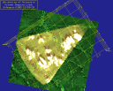
Daniel Forrest created the animation using data from the French SPOT satellite for the terrain, and Lidar data for the atmosphere. On the Kansas map underlying the boundary layer atmospheric data, you can clearly see the Interstate and other roads. The Volume Imaging Lidar (VIL) equipment was located at the tip of the cone-shaped volume scan. The data was collected during the First Field Experiment of the International Satellite Land Surface Climatology Project in 1987. The image shows aerosol structures calculated from volume scans of the atmosphere’s boundary layer.This would have been good publicity for the Lidar group if we’d known about it. It’s too late for a credit in this movie, but we’re trying for the video. The animation we think is used in the movie is called A Top View of a Moving “Fluffy” Boundary Layer. See the MPEG movie to the right.
SSEC in Print
For More Information
Steve Ackerman, an SSEC research scientist who also teaches in UW-Madison’s Department of Atmospheric and Oceanic Science, has attained the pinnacle of academic security. AOS Department Chair Pao Wang revealed in the spring/summer issue of Winds & Waves that Steve starts the fall semester as a tenured associate professor. Steve is sought after by students for his interesting classes, including those where he uses Vis5D and his WxWise Web site.
SSEC on the Airwaves
For More Information
The Discovery Channel’s Raging Planet series featured tornadoes and hurricanes on August 17. Many satellite sequences were used throughout, especially in the hurricanes section. Several were provided by the CIMSS Tropical Cyclone group, including image loops of hurricanes Gilbert and Andrew. Besides the many loops of satellite imagery, McIDAS was shown in use at the National Hurricane Center (now the Tropical Prediction Center). If you’ve ever thought of living on the U.S. coast, especially the eastern coast or the Gulf of Mexico, watch this program. It will change the mind of any prudent person who can live elsewhere.
The New York Times is now producing a television program to complement the weekly Science Times section of the newspaper. Two SSEC scientists have been contacted about their projects for possible inclusion in a series to air this fall on The Learning Channel. Chris Velden was called for a show devoted to the science of hurricanes. John Anderson was contacted about SSEC’s ocean heat flux sensor, designed by SSEC founder Verner Suomi and tested on oceans around the world.
Canal+, a French television station, will use John Anderson’s short video digital Smoke for a program about SIGGRAPH ’97, a large computer graphics show. NHK, Japan, will also use the video. The video was shown at SIGGRAPH this summer. (As of August 26, digital Smoke was not available on the Web.)
Steve Ackerman was interviewed on WISC-TV’s Morning Show to explain and discuss the summer solstice. The show aired June 20. On August 17, WISC2 rebroadcast the production of Talk Box featuring Sanjay Limaye and his work with area school children.
SSEC on the ‘Net
For More Information
The Full Option Science System (FOSS) project at the Lawrence Hall of Science, University of California at Berkeley, is developing a middle school program on the sciences. Its first module deals with planetary science. It will use a colored infrared picture of the earth developed by SSEC programmer Rick Kohrs and former SSEC employee David Sanderson in student and teacher print materials and on a CD-ROM.
McIDAS was used to generate weather maps for the voyage of the Viking ship Snorri. Lands’ End, the Dodgeville, Wisconsin, clothing company, sponsored the voyage, a reenactment of Leif Ericsson’s voyage of a thousand years ago. Lands’ End also hosts a Web site chronicling the adventure. SSEC McIDAS developer Rick Kohrs created maps for the crew showing current weather conditions. The folks at Lands’ End were intrigued by the maps, and wanted to tell their visitors about the place that developed the McIDAS system. SSEC editor Susan Sowinski obliged with an engaging and informative write-up for the on-line magazine Dateline Dodgeville. CBS Sunday Morning, August 3, covered the voyage on site, and mentioned the Web site.
NBC4 WRC-TV in Washington, DC, is making multiple uses of imagery from the SSEC Web site, including Jerry Robaidek’s rotating globe. NBC4 linked to SSEC’s Satellite Composite Imagery from their Web site and has used the rotating globe on their Weathercast. IBM donated the equipment used to produce this complicated imagery through an IBM Shared University Research Grant.
Thanks to the CIMSS Tropical Cyclones Web site, the Air Force Global Weather Center will have new input for its regional and synoptic scale forecasting program. Capt. Brad Schrumpf, chief of the group that trains forecasters for the Pacific, wondered if our derived wind products could help improve his weather forecasts. Chris Velden referred Brad to an article in the Bulletin of the American Meteorological Society, which explains how wind information is used in the Navy’s operational forecasts. Captain Schrumpf plans on using the CIMSS products in training Air Force weather forecasters.
Tim Olander gets the best email! Tim is a researcher with the Tropical Cyclone Team and often hears from people who use hurricane imagery to plan their lives.
- David Marlow and David Adkins on Okinawa used the Tropical Cyclones page to relieve boredom while confined during Typhoon Winnie.
- Trane Francks, in Japan, loves the site, and is using the image of Super Typhoon Rosie as computer wallpaper.
- Robert Bohlin, at the Naval Pacific Meteorological Center in Pearl Harbor, Hawaii, finds the lower-level East Pacific wind product to be a useful tool for locating easterly waves and convergence and divergence areas.
The 53rd Weather Reconnaissance Squadron of the Air Force Reserve is known as the Hurricane Hunters. They are the only Department of Defense organization flying into tropical storms and hurricanes on a routine basis. They fly airplanes right into the eye of the hurricane, and invite you along for the ride! The Hurricane Hunters have linked to the CIMSS Tropical Cyclones Web site from theirs.
The Why Files, produced by UW-Madison’s Office of News and Public Affairs and the National Institute for Science Education, featured the Mars Sojourner Rover in its July 24 column on robots. SSEC scientist Sanjay Limaye is a fact checker for that column.
WISC-TV now links directly to SSEC’s Web site for a satellite view of Wisconsin.
Teaching and Outreach
For More Information
The web site Exploring the Environment features many images from the SSEC and CIMSS Web sites. The site creators hope to use their Earth System Science learning modules to “engage students in self-directed research in relevant environmental and global issues in such a way that they probe, analyze, and weigh information while generating products that demonstrate deep understanding.” Jesuit University, located in Wheeling, West Virginia, and NASA’s Classroom of the Future sponsor the Web site.