Saharan Dust in the Wind
From late spring through early fall the Sahara Desert pulsates with scorching winds that whip up massive clouds of dust and sand, carrying them across northern Africa and far out into the Atlantic Ocean. As this mass of arid air and fine particulate matter flows westward from the African coast, it is undercut by the moist air over the ocean and becomes the Saharan Air Layer (SAL). The dry, dusty, desert air floats 1 – 3 miles above the ocean surface on a cushion of humid air, sometimes growing to be as large as the continental United States and reaching as far to the west as the Caribbean Sea, Florida, and even Texas.
The Atlantic hurricane season, which extends from June through November, overlaps SAL activity each year. During this time the SAL can collide with developing tropical disturbances or preexisting tropical cyclones (TCs). Satellite imagery suggests that when these two weather systems collide, the SAL’s extremely dry air, jets of 25 – 50 mph winds, and warm temperatures may conspire to inhibit the formation of TCs or, if already formed, stifle their ability to further strengthen.
To get a more complete understanding of the effects of the SAL on tropical cyclone development, Chris Velden, Senior Researcher at SSEC’s Cooperative Institute for Meteorological Satellite Studies (CIMSS), is using current and archived satellite imagery and recently acquired data from aircraft field campaigns to study what occurs deep within the turbulent clouds.

Saharan Air Layer moving off of Africa into the North Atlantic on 02 March 2003 captured by Moderate Resolution Imaging Spectroradiometer (MODIS) instrument, aboard NASA’s Terra and Aqua satellite. (Courtesy NASA MODIS Rapid Response Team)
Velden co-authored a 2004 article with colleague Jason Dunion (former graduate student at CIMSS and now affiliated with NOAA’s Hurricane Research Division) in the Bulletin of the American Meteorological Society. Their study proposed the theory that the SAL can inhibit Atlantic hurricane activity.
“We didn’t discover the SAL,” Velden says, “but we brought together some work dating back to the 1970s and 80s, and used state-of-the-art satellite imagery to derive products that illustrated the effects it can have on Atlantic TCs.”
Dunion equates the satellite technology to a new pair of glasses that suddenly brought the hurricane season into a new focus. “We started noticing things we hadn’t seen before. The vast size of these Saharan dust storms and their complex interactions with TCs and seedling tropical disturbances immediately jumped out at us.”
Soon after, Amato Evan (formerly of CIMSS) led another study that included Velden and Dunion as co-investigators. Using specialized satellite observations and algorithms the study attempted to quantify the amounts of dust associated with SAL outbreaks. When the researchers tabulated the 20-year history of dust signal over the Atlantic Ocean TC development region, they found a strong correlation between relatively high amounts of aerosols (SAL dust) and Atlantic TC suppression. From these studies, both Velden and Dunion are reasonably certain that the SAL is one environmental factor that can influence Atlantic TC formation and intensity change. They are quick to point out that although it can be a hindering effect in some cases, it is not necessarily an “on/off” switch for all TCs traversing the Atlantic with a SAL in the vicinity.
“The characteristic dust in the SAL may just be a passive tracer that makes it easier to track in satellite imagery,” Velden says. “However, it is also possible that the dust itself contributes to effects the SAL has on the inhibition process. The dust’s radiative properties act to reflect some of the incoming solar radiation so that the sea surface temperatures below, which provide a heat source for TCs, don’t become as warm as they normally might. In addition, these same properties allow the dust to absorb some of the radiation, thereby creating a temperature inversion within the SAL layer. This stabilizing effect might also be a small contributor to overall inhibition.”

The SAL and Hurricane Erin 2001 (top), Hurricane Helene 2006 (middle), and Hurricane Bill 2009 (bottom). Image courtesy of Jason Dunion NOAA/HRD.
Researchers can track hurricane development from satellites, but it is difficult to study the effect of the SAL using this method. The SAL’s normal altitude is 1 – 3 miles above the Earth’s surface and clouds associated with a TC can swirl to heights of 8 – 10 miles, obscuring the interior workings of the storm from satellites and preventing an easy answer to the question: does the SAL air actually penetrate into the storm circulation and core? If it does, this would prove the Dunion/Velden theory of storm suppression, since it is well known that mid-level dry air can disrupt TCs. An opposing theory is that the storm circulation itself can, if strong enough, effectively repel intrusion of the SAL air, thereby mitigating the effects on storm intensity.
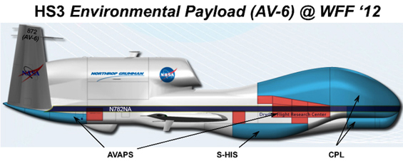
To collect more information, NASA instituted the three-year Hurricane and Severe Storm Sentinel (HS3) project, designed to investigate SAL/TC interaction by using remotely-piloted Global Hawk drones. The Global Hawks fly more than 10 miles above the ocean, giving scientists a unique bird’s eye view of storms. The aircraft carries several instruments and remote sensing packages including the Scanning High-resolution Interferometer Sounder (S-HIS) designed and built at the Space Science and Engineering Center (SSEC). The instrument captures clear-sky water vapor and temperature profiles. Also onboard is the NCAR Advanced Vertical Atmospheric Profiling System (AVAPS), which uses instrumented GPS dropsondes to directly measure temperature, relative humidity, wind, and pressure both inside and outside the TC’s cloudy core.
“What we are ultimately looking for,” Velden says, “is whether the SAL makes its way into the core of the storm. Then we need to show how it can affect the formation and intensity of the TC.”
The HS3 drones have flown many missions far out into the Atlantic over the past two hurricane seasons, but with relatively quiet Atlantic seasons both years, there were few TCs to study.
“Unfortunately, Mother Nature hasn’t fully cooperated with us,” Velden says. “But there have been some good opportunities to study the anatomy of the SAL itself. Data from instruments like the S-HIS are allowing us for the first time to see and better understand the 3-D profile of the SAL. This will give us a baseline for cases when we have an actual TC and SAL interaction.”
Dunion and Velden will compare the data culled from the Global Hawk flights with data from other research missions led by Dunion with the HRD’s P3 Orion and high altitude G-IV hurricane hunter aircraft, to increase their knowledge of SAL/TC interactions. The HS3 project continues for one more year, with more Global Hawk flights planned for the 2014 hurricane season. Velden and his team of researchers hope the next season will supply more SAL/TC interaction, allowing the project to unlock a remaining mystery so that they can make further refinements to hurricane forecasts.
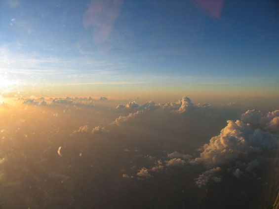
Photo of the Saharan Air Layer during a Saharan Air Layer Experiment mission on 18 September 2006. Saharan dust gives the sky an orange glow during this late afternoon sunset in the eastern Caribbean. Small cumulus clouds poke through the tops of the dust layer. Photo credit: Jason Dunion NOAA/HRD.