Sky Cover: Shining Light on Cloudiness Forecasts
By Zhengzheng Zhang
On a cloudy afternoon in December, Jordan Gerth presented his Ph.D. defense in the Department of Atmospheric and Oceanic Sciences, UW-Madison. While his dissertation title “Sky Cover” has only nine characters, those few letters reveal a unique contribution to our understanding and quantification of “sky cover” in meteorology.

Jordan Gerth
Photo Credit: SSEC
Gerth’s research is an important breakthrough because clouds are fundamental to the earth system, with important connections to temperature, moisture and precipitation processes in the atmosphere. Cloudy conditions impact everything from everyday life to global industries like air travel and the renewable energy sector, making accurate forecasts even more important. While cloud conditions are a critical component of numerical models for short-term weather forecasts, the methods used to quantify them are under-developed. Gerth’s research outlines a way to accurately represent clouds in numerical models.
According to Gerth, sky cover, by definition, is the hour-averaged quantity of cloud coverage (percentage) within the celestial dome–the amount of sky from horizon to horizon as seen from a single point. The quantity is not only one of the most complex meteorological parameters collected and observed daily, but one that is ambiguously defined and difficult to quantify. How cloud fraction and sky cover are understood affects both daily weather forecasts and global climate predictions.
The National Weather Service (NWS) has long provided sky cover forecasts as part of the weather information supplied to the public. NWS meteorologists routinely produce gridded sky cover forecasts and submit them to the National Digital Forecast Database (NDFD), making weather forecasts available to anyone with a computer and internet access.
However, discrepancies in the NDFD sky cover forecasts remain due to lack of a suitable sky cover analysis, which can be used for validation purposes, and inaccurate representation of cloud patterns in numerical weather prediction models.
“In terms of NWS operations, sky cover is probably one of the most underdeveloped fields. I think we do a better job with temperature, dew point, and a lot of other fields. But when it comes to sky cover, there is not much work done formalizing this quantity,” Gerth said.
The inconsistencies in cloud definition or parameterization result in weakened global circulation and numerical weather prediction (NWP) models. The forecast community needs better observational methods to assess the performance of cloud parameterizations in models because the current parameterization technique is based on assumptions that are difficult to evaluate.
Referring to this need, Gerth noted that sky cover can be an effective tool in assessing how weather and climate models handle cloud coverage, since it offers a different formulation for treating cloudiness compared to traditional definitions. Its greatest strength is that sky cover is an observable quantity, and much more characteristic of the surrounding atmosphere for validation than traditional observations at a single, fixed point.
To quantify the concept of sky cover and better forecast cloud cover, Gerth devised a methodology to incorporate properties of both geostationary satellite and surface observations of clouds into a single sky cover analysis, called the blended sky cover analysis. Gerth explained that “the ‘blended’ method complements and balances the two observations from surface and space-based observing systems, and improves the detection of low clouds at night, and high clouds in general, compared to a single source.”
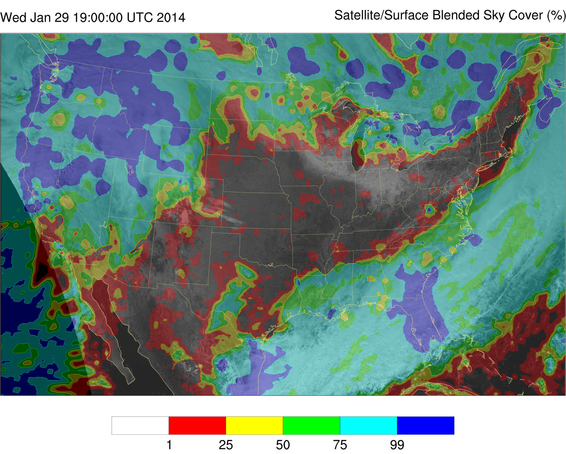
The blended sky cover analysis (foreground) from 29 January 2014 captures areas of thick cloud over the Pacific Northwest, Canada, and Florida (blue). Snow cover under clear skies in the Great Lakes region is evident in the geostationary satellite visible image from 1:02 PM CST (background). The analysis correctly does not classify snow cover as cloud, a common challenge when determining cloudiness using satellites. Photo Credit: Jordan Gerth.
In addition to formalizing sky cover as a quantity, Gerth investigated the relationship between sky cover and other atmospheric variables in cloud-resolving NWP models. He also examined how to improve forecasts of short-term cloudiness and moisture quantities in NWP models. Gerth discovered that relative humidity and the cloud water mixing ratio are closely correlated with sky cover, particularly in the lowest levels of the troposphere-that part of the atmosphere nearest the surface-and, that cloud and moisture quantities contribute to the cloud and sky cover outputs that NWP models provide.
Gerth defined a framework for optimizing the blended sky analysis based on the current near-term human-produced forecasts from the NDFD. The optimization approach produces a sky cover product with decreased mean errors, resulting in short-term forecasts that are more accurate than those from the current operational cloud-resolving NWP model, the High-Resolution Rapid Refresh (HRRR).
As Gerth explained, sky cover analysis improves weather forecasts because “all weather variables are interrelated; the change of forecasts from ‘cloudy’ to ‘clear’ could have significant impact on high or low temperature forecasts.”
Gerth is particularly interested in connecting science with real-world operations. From his perspective, “just because it is great science does not mean it’s going to be a valuable tool for forecasters to determine whether it will snow tomorrow.” His approach has consistently focused on making good science valuable and beneficial to operational forecasters.
Research-to-operations is not a new concept to Gerth. In 2007, as an undergraduate, Gerth won the National Weather Association Meteorological Satellite Applications Award for his role in a CIMSS project that was transitioning satellite imagery from research to operations.
In the project, CIMSS scientists provided Moderate-Resolution Imaging Spectroradiometer (MODIS) imagery and products to NWS Forecast Offices in a format that could be displayed in their system, the Advanced Weather Information Processing System (AWIPS). This new use of MODIS imagery helped operational forecasters to more accurately predict weather patterns and phenomena.
“Research-to-operations is a buzz word now, but it was a novel concept” at that time, Gerth recalled. His undergraduate research focused on providing forecasters with sea surface temperature information extracted from MODIS observation data.
“Here in CIMSS, we really pioneered that concept of taking our research and applying it to the operational world. Within the field of meteorology, particularly satellite meteorology, that was not something done routinely in the mid-2000s.”
Though Gerth’s sky cover product is not finished, he and his coworkers have begun sending it to a few test and operational sites. They are introducing the sky cover product to the NWS and comparing its outputs to those of other weather models.
Gerth successfully defended his dissertation, and he will continue these efforts as a postdoctoral research associate at the Space Science and Engineering Center (SSEC), UW-Madison.
When asked about his future career goals, Gerth said, “I am very happy to continue to sit on this interface between science and operations. Better connecting the research to the operations is not only important but something that is very unique to atmospheric science. It is a mutually beneficial relationship that in turn can help scientists come up with ideas to promote progress in atmospheric science. I see my ongoing role as a bridge between research and operations.”