Center of the storm
A hurricane’s eye – an area of relatively low pressure and wind – is one of its most distinctive features. It stands in stark contrast to the storm’s strongest winds found on the other side of the eyewall: the eye is a region of calm surrounded by raging wind.
While studies have examined different features of hurricane eyes, like their formation and structure, until now, little research has been conducted to understand their frequency.
“The presence of an eye is important because it generally indicates a more intense storm,” says researcher Tony Wimmers of the UW-Madison Cooperative Institute for Meteorological Satellite Studies (CIMSS).
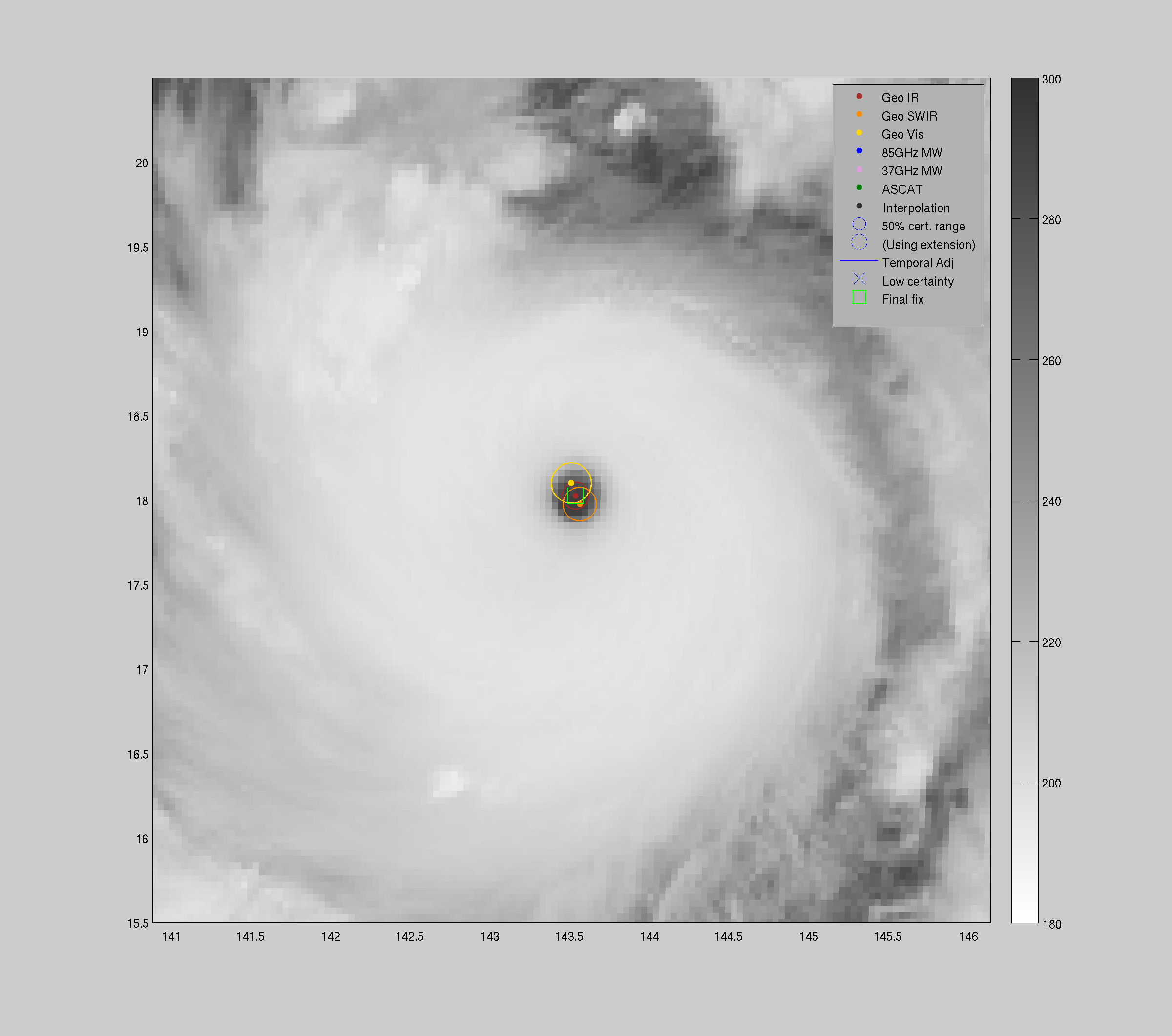
ARCHER is a tool for research purposes that allows the interrogation of large satellite datasets in a short amount of time, as was demonstrated in this study. It is also an operationally-viable option for hurricane analysts to pinpoint and characterize hurricane eyes in real time.
Credit: CIMSS
Using satellite infrared imagery from the Hurricane Satellite (HURSAT) and the Automated Rotational Center Hurricane Eye Retrieval (ARCHER) algorithm, Wimmers is part of a collaboration that has uncovered a wide range of factors associated with hurricane eye frequency and has formulated a climatology to better understand changes in hurricane development.
Wimmers and his co-authors provide an analysis of hurricane eyes over a 34-year period (1982-2015) in their paper, “A Global Climatology of Tropical Cyclone Eyes,” that was published in the Monthly Weather Review in July 2018.
Eye development
The researchers used ARCHER to assist them in sorting through thousands of hurricane images. The program is designed to rapidly scan and collect information throughout each storm’s life cycle. After identifying the rotational center, the software determines whether the hurricane has developed an eye, if so, ARCHER records dimensional data like diameter, size and completeness. On average, hurricanes have a lifespan from five to seven days, although some have been recorded to exist for nearly a month. If a hurricane is destined to develop an eye it will tend to form after the fifth day but rarely lasting beyond the 16th day.
Eye locations
Based on the 34-year climatology, the team of researchers identified a major difference between hemispheres and the number of eyes that form. Hurricanes in the northern hemisphere produce significantly more eyes, but storms in the southern hemisphere tend to have larger eyes.
Windspeeds
While eye formation is linked to the circulation and symmetry of the storm: storms with certain windspeeds are more likely to produce an eye. On average, storms with winds greater than 65 kt produced eyes (with a median windspeed of 97kt). Storms with winds slower than 35kt did not have eyes.
Shifts in hurricane ranges:
The locations of hurricane eyes over the decades have shifted, supporting previous findings of their poleward migration. This migration away from the tropics and toward the poles may mean that future hurricanes could make landfall in areas such as heavily populated coastal cities, where they previously have not.
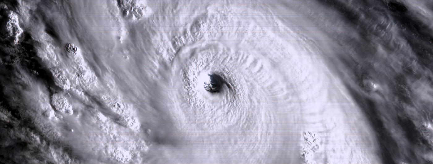
Hurricane Irma and its distinct eye were captured with the GOES-16 satellite on September 07, 2017. The category 5 hurricane remains one of the strongest hurricanes ever recorded over the open Atlantic Ocean. Credit: SSEC
“By using the ARCHER program to rapidly scan these data we were able to independently confirm an important finding,” says Wimmers. “The goal of ARCHER is ultimately to improve forecasting of hurricane tracks, or improve the real-time estimate of hurricane intensity, by objectively identifying the characteristics of a storm around its center. This includes ‘hard’ cases as well as easy cases like clear, circular eyes.”
ARCHER is used as a real-time operational forecasting tool for tropical cyclones. The JPSS Risk Reduction program is supporting the integration of ARCHER into operations at the NOAA National Hurricane Center and other hurricane forecasting offices.
The development of the ARCHER tool was supported by the Office of Naval Research through the Naval Research Laboratory in Monterey, CA. Continued transition of ARCHER into operational National Weather Service applications is being supported by the National Oceanic and Atmospheric Administration.
Reference: Knapp, K.R., C.S. Velden, and A.J. Wimmers, 2018: A Global Climatology of Tropical Cyclone Eyes. Mon. Wea. Rev., 146, 2089–2101, https://doi.org/10.1175/MWR-D-17-0343.1
By Eric Verbeten