Satellite frontiers
Since the era of satellite meteorology began in the 1950s, the continued investment in remote sensing instrumentation has elevated the science and resulted in marked advancements in the understanding of the Earth’s atmosphere, climate and weather. As the University of Wisconsin–Madison Space Science and Engineering Center (SSEC) looks to the future of satellite instrument development, geostationary-based hyperspectral infrared sounders represent the next frontier for improving global weather prediction and severe weather warnings.
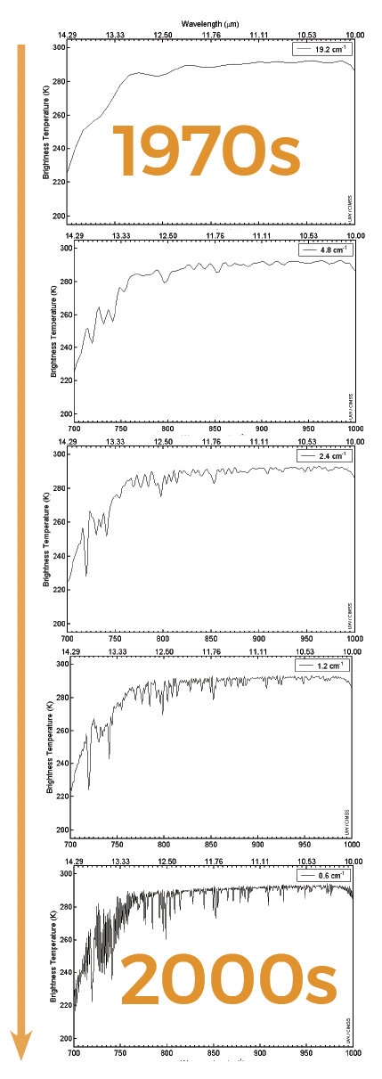
A historic progression of IR sounder resolution improvements, beginning with the High Resolution Infrared Radiation Sounder (HIRS) in the mid-1970s, to the Atmospheric Infrared Sounder (AIRS) in the 2000s. Credit: Paul Menzel
For decades, most space-based IR sounders have been carried on polar orbiting satellites. While the current array of polar orbiting satellites provides strong global coverage, there are inherent drawbacks to the system, namely temporal coverage. A geostationary IR sounder on the other hand, excels at observing rapidly developing weather systems from a fixed location. Together, the two types of sounders can create a more accurate picture of weather system development.
But, unlike other countries, the United States has no formal plans to deploy an advanced geostationary IR sounder, says Paul Menzel, senior scientist with the UW–Madison Cooperative Institute for Meteorological Satellite Studies (CIMSS), housed within SSEC.
Infrared sounders (and modern hyperspectral IR sounders) play a major role in identifying the atmospheric state defined by temperature, humidity and cloud properties, he says. As a precursor to severe weather, changes in these conditions are vital to identifying atmospheric instability and improving weather forecasts.
As with any instrument array, technological diversity is key. Providing comprehensive coverage for something as large (and complex) as Earth’s atmosphere cannot be achieved with any single satellite platform. Instead, a mix of sounders, imagers and other remote sensing devices are needed to provide the crucial data for severe weather prediction and global climate modeling. IR sounders complement other instruments by providing a continuous wide-angle view along with the ability to peer deep into the atmosphere – gathering data within a vertical profile.
In 2018, after conducting an Observing System Simulation Experiment, a team of CIMSS researchers, led by Dr. Jun Li, and the National Oceanic and Atmospheric Administration (NOAA) concluded that the inclusion of hyperspectral IR sounders on U.S. geostationary satellites could fill essential data gaps and lead to significant improvements in predicting local severe weather.
Looking back, SSEC’s involvement with IR sounding technology can be traced to the late 1960s after the center was co-founded by Verner Suomi. He envisioned using satellites as a platform to observe Earth’s weather. Quickly the utility of these space-based systems became apparent for the field of numerical weather prediction (NWP).
“The use of an infrared sounder from space got its start in 1969,” says Menzel. “The development of the instruments (SIRS-A and IRIS-A) to fly aboard the Nimbus-3 satellite, which were the first IR sounders to fly in space, showed the way.”
In the coming decades, major improvements would affect nearly every aspect of the IR sounding field, from improved spectral resolution, to new detection capabilities, to the analytical methods used for data assimilation in numerical models.
Among the wide-range of frequencies used to look at the Earth’s weather, an IR sounder’s strength comes from its multitude of spectral measurement channels to reveal a detailed vertical profile. As improvements in the detectors were realized, this would have a notable impact for the NWP community. In 1978 the launch of the polar-orbiting weather satellite TIROS-N marked a milestone with its IR sounder (HIRS-2) becoming the first to be used routinely for global NWP, transitioning the technology from an experimental era to an operational one.
“Around this time, these data were helping to create a truly connected and comprehensive view of Earth’s atmosphere by measuring water vapor and temperature,” says Menzel.
Until the late 1970s, IR sounders had only flown aboard polar orbiting satellites, but a growing interest expanded around the idea of fixing them to a geostationary platform. In 1980, with much of the instrument development, data analysis and processing conducted at SSEC in collaboration with NOAA and NASA, the Visible Atmospheric Sounder (VAS) aboard GOES-4 became the first experimental sounder to be used on a geostationary satellite. This initial experimental design proved successful, and later in 1994, through a separate mission, the technology became operational with the launch of GOES-7.
As a way to further improve the capabilities of IR sounders, SSEC Senior Scientist Hank Revercomb and his colleagues designed a new geostationary sounder called the High-resolution interferometer Sounder (HIS) and proof-of-concept interferometers for testing on high-altitude aircraft like the NASA ER-2, a converted former U2 spy plane. The aircraft served a new research purpose and could reach altitudes of 70,000 feet, high enough for instrument tests and satellite validation.
“From this elevation you could look down and see through almost all of Earth’s atmosphere,” says Revercomb. “This made for an accessible way to test IR sounding equipment without the high costs associated with satellite launches.”
From these early test flights in the mid-1980s, the HIS program emerged as an innovative testbed for new IR sounder designs and techniques. One of which, would turn the sounding world upside down through a literal inversion of the instrument and using it for ground-based observations. An IR sounder’s ability to peer through much of the atmosphere proved to be invaluable as a means to collect information about the boundary layer and higher altitudes. Since the early 1990s, SSEC’s Atmospheric Emitted Radiance Interferometer (AERI) program has expanded to be part of a worldwide network of atmospheric monitoring stations.
SSEC continued to support the development and testing of IR sounders for other space-based missions included the Atmospheric Infrared Sounder (AIRS) aboard the Earth Observing System (EOS) Aqua satellite, the Infrared Atmospheric Sounder Interferometer (IASI) on the European Space Agency’s MetOp, and most recently the Cross-track Infrared Sounder (CrIS) in orbit on two US polar satellites, Suomi NPP and NOAA-20.
The first high spectral resolution geostationary IR sounder to go up, the Chinese Geostationary Interferometric Infrared Sounder (GIIRS), was launched on the FY-4 satellite in 2017. Future missions include the European Meteosat Third Generation satellite with its Infrared Sounder (IRS), scheduled to launch in 2022.
Infrared sounders (and modern hyperspectral IR sounders) play a major role in measuring atmospheric variables like temperature, humidity and cloud properties. As a precursor to severe weather, changes in these conditions are vital to identifying atmospheric instability and improving weather forecasts. Credit: SSEC
In addition, the World Meteorological Organization outlines in its “Vision for a Global Observation System in 2025,” the need for at least six geostationary satellites equipped with advanced infrared sounding capabilities.
SSEC researchers and engineers are continuing to build better and more sensitive sensors with improved accuracy and spectral and spatial properties. As the evolution of sounding devices proceeds, Menzel and Revercomb remain hopeful that the US will launch its own geo-sounder, joining the international effort and improving NWP forecasting.
“We have come a long way to understand the improvements offered by IR soundings with spectral, spatial, and temporal sampling in balance,” says Menzel. “It remains to realize these improvements in geostationary orbit.”
Reference: Menzel, W.P., T.J. Schmit, P. Zhang, and J. Li, 2018: Satellite-Based Atmospheric Infrared Sounder Development and Applications. Bull. Amer. Meteor. Soc., 99, 583–603, https://doi.org/10.1175/BAMS-D-16-0293.1