Geo2Grid: New software puts the power of geostationary data in users’ hands
Geo2Grid is an open source software package designed to create high resolution images from geostationary satellite data. Released in early March 2019, researchers at the Space Science and Engineering Center created Geo2Grid as part of the Community Satellite Processing Package for Geostationary Satellite Data. They designed it with ease of use in mind.
“The Geo2Grid software takes the complicated process of merging, scaling, sharpening and projecting geostationary datasets and makes it accessible to anyone who wants to create high resolution true color or false color images,” says SSEC scientist Kathy Strabala.

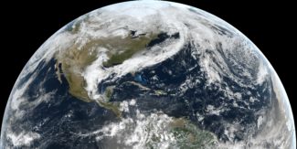
A true color image created using the Geo2Grid software package. Click here for a high resolution version. Credit: SSEC
Geo2Grid works on geostationary datasets that are provided by the user. It is capable of producing full resolution images and videos using any of the bands and modes available from satellite imagers like the Advanced Baseline Imager on GOES-16 and -17, and the Advanced Himawari Imager on Himawari-8. Users can find geostationary datasets from a variety of sources, including free GOES-16 and -17 datasets referenced here.
Designed with rapid processing in mind, Geo2Grid can be used for near-real time imagery and multicore systems. And because the software comes with all of the required sub-programs and libraries included, the system is portable.
Geo2grid is built primarily around the programming language Python, however, users do not need to know the computer language to use it.
“The Python code and libraries run in parallel from a simple command line interface,” says SSEC software engineer Dave Hoese and primary architect of the system. “The images created can be specified to any dimension and can be used with GIS tools like Google Earth.”
Geo2Grid is the companion software to the Polar2Grid program launched in early 2013. Download and manuals are available on the Geo2Grid webpage and a brief how-to can be found on the CIMSS Satellite Blog.
This work was funded by NOAA GOES-R STAR Program
