Reduced latency for improved forecasts
When data latency is lowest, weather forecast accuracy is near its highest. This relationship between low latency – or the most current and complete data – and forecast accuracy, is crucial when running Numerical Weather Prediction models.

A study conducted by researchers at the University of Wisconsin-Madison Cooperative Institute for Meteorological Satellite Studies (CIMSS) and the National Oceanic and Atmospheric Administration (NOAA) investigated the impacts of missing data for predicting local severe weather. Additionally they confirmed the importance of having the most up-to-date conditional data prior to model runs. Their work was published in January 2020.
“We wanted to see how satellite observations and latency can affect precipitation forecasts, especially in severe storms,” says Pei Wang, CIMSS researcher and lead author. “For local severe storms, they can drop a lot of precipitation in a short time, so time matters.”
The data that underpin forecasts come from several sources, including weather balloon radiosondes, dropsondes, aircraft data and satellites. However, at times, certain data are unavailable from polar orbiting satellites due to their varying orbital paths, which can result in prediction models being forced to run using less relevant data.
Specifically, latency, is the measure of time before a weather model is run and the availability of the latest data to make a forecast. For example, if a regional weather model is set to run at 12:00 (noon) for a specific location, satellite data that are received at 11:00 a.m. would be considered 1-hour latency. The greater the latency, i.e. two, three, or four hours, the less useful those data are for making a forecast. An optimal situation includes the six hours preceding the model run and includes 0-hour data as well, that is, the most up-to-date conditions over the area.
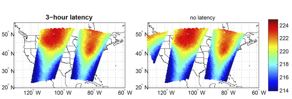
The researchers selected case studies from events in Colorado and Kansas to compare model predictions to past weather events. This allowed them to assess how varying latencies affected forecast quality. Overall, there was a notable improvement in forecast accuracy when latency was at its lowest.
Wang and her colleagues conducted several simulations using data from infrared sounders on polar orbiting satellites like US Suomi-NPP and NOAA-20 and the European Metop-A and Metop-B. These data were run primarily through the Weather Research and Forecasting (WRF) model as well as other regional/continental models like the Rapid Refresh (RAP) and the High-Resolution Rapid Refresh (HRRR). The study did not include data from geostationary satellites like GOES-East.
Wang says this research shows the importance of up-to-date information provided by satellites for accurate forecasts. In many instances, some of that data may not be available for a region, but direct broadcast sites around the country can help supply these data and fill in the gaps.
This work was supported by the NOAA Technology Maturity Program.
Cover photo by Scott Lindstrom.