Natural disaster risks – Resilience research in a changing climate
Extreme weather, like heavy precipitation, is increasingly linked to climate change. Preparing for those events involves gauging community risk and resilience. These adaptations to climate change and pandemic impacts are now part of the equation to avoid tragic loss of lives and property.
Credit: Shane Hubbard
Shane Hubbard dedicates his time and expertise to quantifying and visualizing those risks. He is a researcher at the University of Wisconsin–Madison Cooperative Institute for Meteorological Satellite Studies who uses data and geospatial modeling techniques to identify areas at risk of hazardous events like floods, tornadoes and hurricanes. Armed with that information, the communities he assists can better anticipate — and weather — these events.
For example, if communities want to be resilient, they need to think about whether certain areas should be designated as floodplains, which would prohibit any building on them. Estimating the location of future floodplains is another important aspect to Hubbard’s work. In addition to the loss of life and property, the financial impact of severe weather can be devastating.
“Each year there are larger dollar losses due to disasters and more people impacted, even when adjusted for inflation,” says Hubbard.
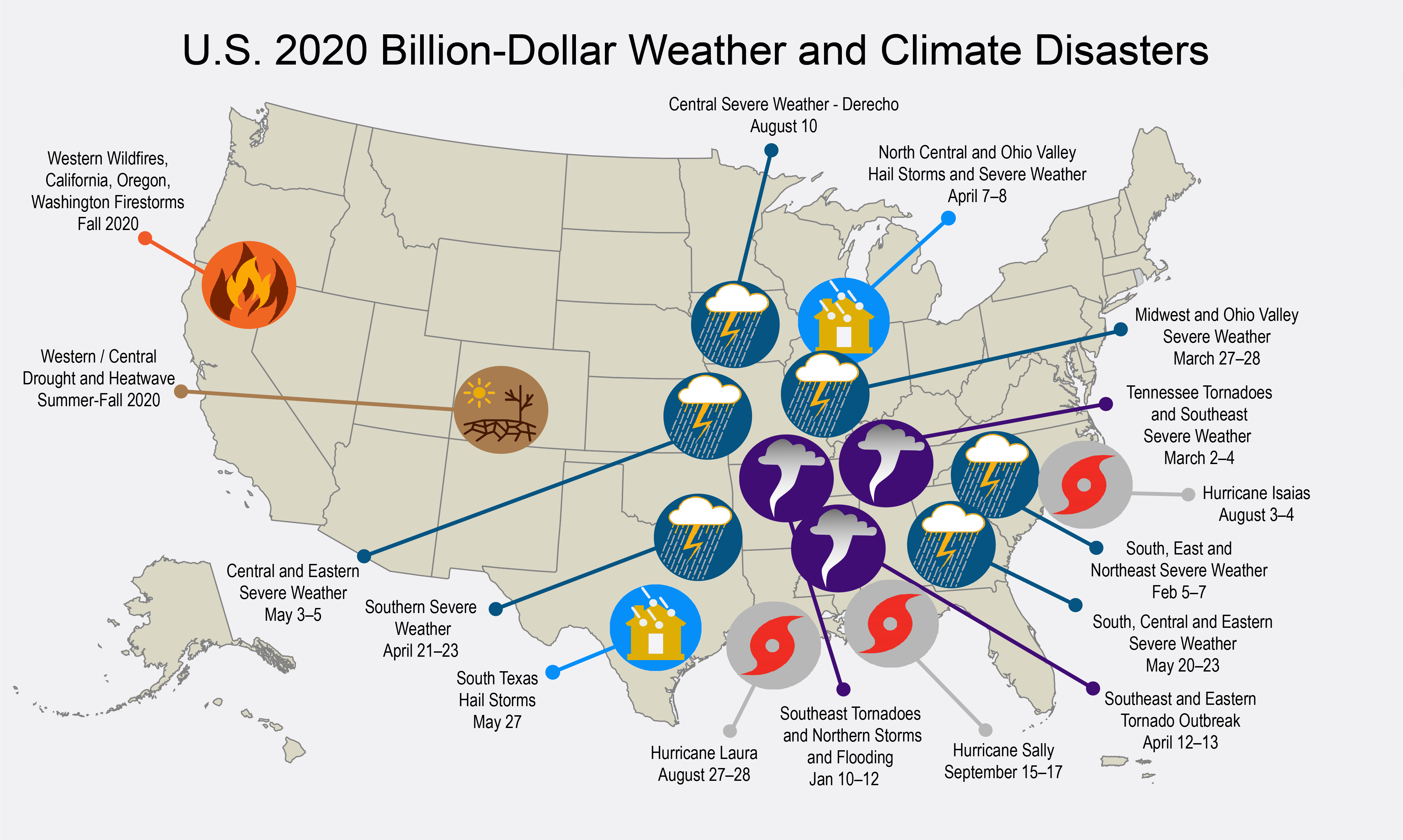
According to NOAA’s National Center for Environmental Information, during the period 1980-2020 (through Oct. 7, 2020), the United States experienced 279 hazardous events each costing $1 billion or more; however, nearly 30 percent of those events occurred since 2015.
Overall, tropical cyclones have caused the most damage and losses. That is because about 127 million people, or 40 percent of the US population, live in counties that border a coast. While the land mass on the coasts is small relative to that of the contiguous US — only 10 percent of its total — the population density is five times greater than it is inland. This density is an important factor that increases the threat of damage and loss of life.
“The way that we construct our communities is a detriment to having any sort of buffer for climate change,” says Hubbard. “People continue to want to live in areas that are becoming more vulnerable to disaster as the climate changes.”
Tools such as flood maps can help to identify who is at risk and who needs flood insurance, but their boundaries are binary. That is, they prevent construction inside the boundary, but allow it immediately outside: there is no gray area. One more foot of water during a storm can cause flooding in areas where people live and work.
“This is very apparent on the coasts where floods can push in quite far, over a mile,” says Hubbard.
He adds that climate change is not a one-to-one ratio that results in a linear change to the hazard risk. Rather, the way communities are built exposes them to an exponential increase in risk while at the same time, rendering them less resilient to changes in climate. Making adjustments in our built environment in anticipation of weather and climate change is one way to moderate their harmful effects.
After Hurricane Andrew — a storm that destroyed 63,000 homes and bankrupted nine insurance companies in August 1992 — Florida began adopting stronger building codes. Emergency services, insurance companies, firefighters, and engineers were among the groups in support of them. As a result of adopting more rigorous codes, Floridians who lived in homes built after Andrew weathered subsequent Hurricane Irma in September 2017 much better than those who lived in older homes.
However, not everyone supports more robust codes. “These can be wildly unpopular for various reasons, but one of the biggest reasons is that stronger building codes can result in more expensive buildings,” says Hubbard.
Closer to home, Wisconsin lakes, streams and rivers are not immune from hazardous weather events. Hubbard notes that annual precipitation amounts are not increasing much across the Midwest, but places like Wisconsin are experiencing shorter periods of intense rainfall accompanied by flash flooding.
“We are now seeing our biggest floods in June, with torrential rains, rather than in May as a result of spring melting,” says Hubbard.
This shift is changing how planners think about seasonal flooding. It is also pushing planners to focus more on the pre-flood environment and to consider mitigation strategies.
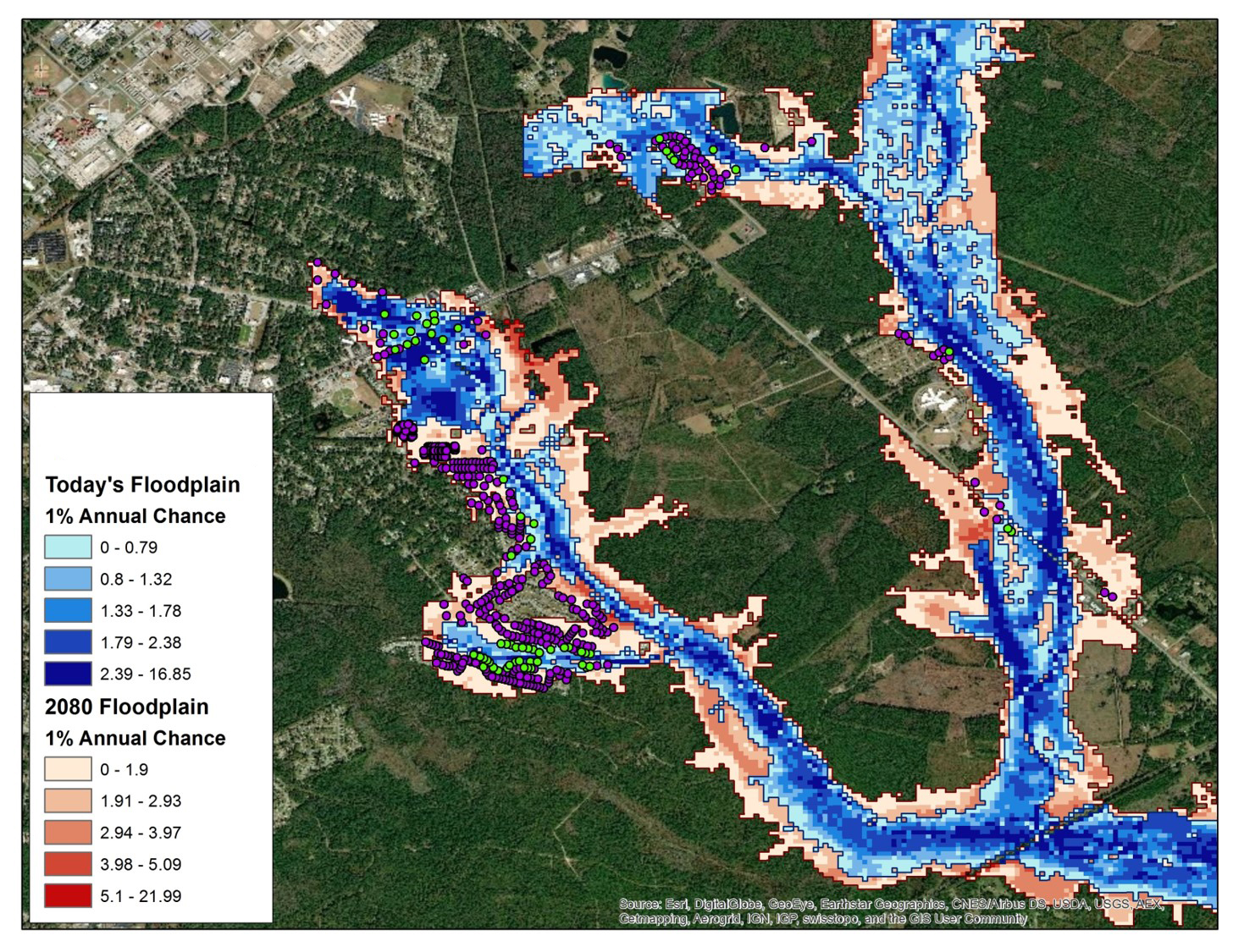
Hubbard, along with UW–Madison climate researchers Steve Vavrus and Michael Notaro, is working with officials in Sauk County, Wisconsin to provide outlooks on future precipitation patterns.
In August 2018, parts of the Baraboo River in Sauk County met, or exceeded, the one percent annual chance for a 100-year flood, causing widespread flooding, evacuations and property damage.
Rather than revising existing flood maps with recent flood data, the researchers will be providing Sauk County with estimates of future floodplains based upon simulations of future precipitation for the area.
Hubbard will combine those flooding estimates with information on at-risk individuals, property and agricultural areas to show how different parameters might change the possible impacts or outcomes in the future. Understanding these possible scenarios today will guide planning for Sauk County’s future growth.
Hubbard says that in any area prone to natural disasters, like flooding or hurricanes, the more financially stable a population is, the more resilient that population will be. Adequate financial resources make people more mobile and able to relocate if disaster strikes; however, people who lack those resources may find themselves at even greater risk, thereby further widening the gap between those who are financially secure and those who are not.
Viewing these layers of data over floodplains or other areas gives local leaders a picture of at-risk populations.
In an expanded project, Hubbard will be reviewing current floodplains across Wisconsin as part of a statewide flood assessment to aid preparation for — and adaptation to — a near future that may include more torrential rains.
What concerns Hubbard most this year is that several hurricanes, from Category 1 to Category 4, have made landfall in the US at a time when the nation is dealing with a pandemic. The combination creates another type of perfect storm. For a large metropolitan area, a strong hurricane could pose problems in transporting the injured to hospitals where they can receive medical care, especially if they are already overwhelmed with COVID-19 cases.
“The recovery will be longer, too.” says Hubbard. “With Hurricane Irma, people went a week or two without electricity, but in the current environment I see the potential for people to be without power for four to six weeks because fewer resources may be available in areas where positive COVID-19 numbers are high and physical distancing a challenge.”
The same is true for those who must evacuate to a shelter during a storm as well as those who volunteer to help in its aftermath. Hubbard says that when appropriate, people may be advised to shelter-in-place and because of the physical distancing requirements to limit transmission of the virus, he fears we may see fewer volunteers.
While combating COVID-19 is an urgent national need that must be addressed, it may create an all-too-familiar scenario where future appropriations to activities such as disaster planning and mitigation are reduced.
“Historically, funds for pre-disaster mitigation — like elevating a house out of a floodplain or building a flood wall — is the type of thing that gets cut when we have budget constraints,” says Hubbard.
With these concerns in mind, Hubbard continues his work of helping communities to prepare — because natural disasters are not going away.
This work is supported by the Federal Emergency Management Agency and administered through Sauk County, Wisconsin.