Continuing the MODIS legacy
For more than 20 years, a complementary duo of weather satellites have delivered stunning imagery of Earth and crucial data about its atmosphere which have been used to improved daily weather forecasts. Designed with a mission timeline of roughly 10 years, NASA’s Terra and Aqua satellites continue to perform beyond expectations.
The satellites’ two-decade legacy of infrared data is valuable to the study of Earth’s climate and how it is changing. However, recent maneuvers by NASA in February 2021 reveal that the aging satellites will eventually have to be retired because of changes in orbit and their timings.
Anticipating this change, scientists at the University of Wisconsin–Madison Space Science and Engineering Center are combining data from two newer satellite instruments as a way to create an analogous dataset to the historic satellites.
Terra and Aqua carry a specialized instrument known as the Moderate Resolution Imaging Spectroradiometer, or MODIS, which captures a range of imagery and atmospheric data. As satellite technology improves, maintaining consistent records from generation to generation is challenging.
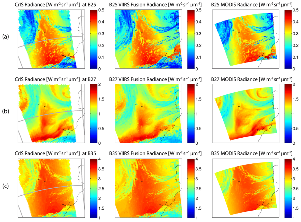
The Suomi-NPP and NOAA-20 satellites, successors to Terra and Aqua, are equipped with a newer, high-spatial resolution infrared imager known as the Visible Infrared Imaging Radiometer Suite (VIIRS). The VIIRS instrument provides detailed observations near the Earth’s surface and includes a day/night band that allows for continuous imaging regardless of time of day. Conversely, a complementary detector, the Cross-track Infrared Sounder (CrIS), is used to peer through the upper layers of Earth’s atmosphere and provide data needed for numerical weather prediction.
While MODIS has seven spectral bands that are sensitive to atmospheric carbon dioxide, water vapor and ozone, VIIRS lacks these bands which can affect the continuity of atmospheric measurements. Although CrIS has a lower spatial resolution, it provides a robust set of measurements – more than 1300 spectral channels – ranging from 3.9 to 15.4 micrometers.
Researchers at SSEC have devised a way to combine the CrIS measurements with the high spatial resolution VIIRS measurements.
“With a so-called data fusion method on these two sensors, we were able to construct infrared absorption radiances similar to MODIS,” says SSEC scientist Eva Borbas. “We have created a new water vapor product based on the VIIRS and CrIS fusion radiances in order to make it comparable to the MODIS data from the last two decades.”
The result is the VIIRS Fusion Moisture Product that captures retrievals from the troposphere and tracks total precipitable water measurements. It also demonstrates the potential of the fusion of IR absorption spectral bands in continuing the moisture record from MODIS and the previous generations of polar-orbiting satellite sensors.
The continuation of such high-spatial resolution moisture products will help researchers observe weather phenomena, improve nowcasting, detect urban heat islands as well as calibrate other high-spatial resolution remote sensing products, similar to the imaging and sounding capabilities of MODIS.
This work is supported by SSEC