Measuring atmospheric moisture from airplanes
It may be little known, but some 3500 commercial airplanes worldwide are equipped with external sensors that make atmospheric measurements on their cross-country or global journeys. Measurements like wind speed and temperature are important for safe air travel, but others, like moisture, do not provide an immediate operational benefit to aviation. They do, however, play an important role in producing weather forecasts that the industry relies on.
With its central role in Earth’s weather and climate, moisture, or water vapor, evaporates from the surface and condenses to form clouds which then release precipitation in a global and continuous cycle. How much water vapor is in the atmosphere, and where, is a crucial component of numerical weather prediction.
To improve the availability of these types of measurements, graduate student Skylar Williams joined Tim Wagner and Ralph Petersen, researchers at the University of Wisconsin–Madison Cooperative Institute for Meteorological Satellite Studies, who were comparing water vapor data collected from sensors on commercial aircraft to water vapor data collected from weather balloons equipped with radiosondes.
Their work built on earlier studies by using United States radiosonde data from 2015 that provided a cross-section of locations, climates and seasons. Results were published in the Journal of Atmospheric and Oceanic Technology in Spring 2021.
“Weather data can be gathered from commercial aircraft and used on a daily basis to help with forecasting and other areas,” says Williams. “It is great for gap-filling data, augmenting weather balloon data or for use in places that don’t have the weather data access that we do.”
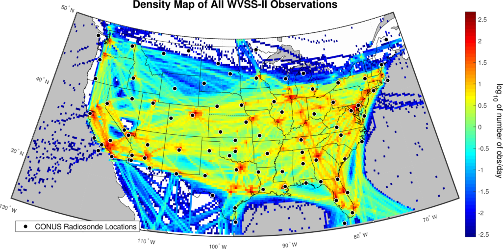
Credit: Skylar Williams
Twice a day, at midnight and noon Greenwich Mean Time — 7:00 a.m. and 7:00 p.m. Central Daylight Time — weather balloons are launched around the globe to collect data that provide a snapshot of the atmosphere around a given location. The US National Weather Service operates or supports more than 100 of the nearly 800 locations worldwide. Those overseen by the NWS are located in North America, the Pacific Region and the Caribbean.
Despite the fairly large radiosonde network in the US, the locations are often spaced too far apart, especially when forecasters are analyzing mesoscale features of developing storms — storms that may span up to 1000 kilometers. In these larger storms, environmental conditions on one side of the storm boundary might be different than those where the balloon launch occurred, says Williams. These differences can impact the accuracy of forecasts.
To help collect more frequent data, about 150 commercial aircraft — operated by United Parcel Service and Southwest Airlines in the US — have been equipped with a specialized Water Vapor Sensing System. Coordinated by the World Meteorological Organization Aircraft Meteorological Data Relay program, the arrangement makes data freely available to researchers and meteorological agencies worldwide.
Altogether, the aircraft transmit about 900 profiles each day that are more frequent and at a greater density than those of the US radiosonde network. In addition, aircraft take measurements every 100 meters during ascent and every 300 meters during descent and at cruising altitude. The result is a robust set of measurements of the boundary layer — the atmospheric layer closest to the surface where most weather occurs — as well as tropospheric measurements.
“The ascent and descent are really what we care about because that creates the profile,” says Williams. “But we also get the upper atmosphere, for a top-to-bottom slice, and I don’t think there is another observing system that routinely provides this except for maybe a satellite which has a coarser resolution.”
These slices are especially important because water vapor distribution in the atmosphere varies horizontally and vertically.
To transmit the water vapor data, the WMO has taken advantage of an existing communications system known as the Aircraft Communications Addressing and Reporting System, or ACARS, that facilitates transmissions between aircraft and ground stations using radio or satellite links. The water vapor data are transmitted along with all of the other aircraft flight data but are encoded as atmospheric measurement data without identifying the source as UPS or other aircraft.
“Some models are ingesting these data to help improve forecasts in areas that lack enough observations,” says Williams. “In the last year; however, it’s been a problem because there was a huge data loss when aircraft were grounded due to the pandemic.”
There are several advantages to the WVSS data collection system over the radiosonde, says Williams. The WVSS can be used multiple times whereas the radiosonde is a one-time use instrument. In addition, it is not unusual for things to go awry with weather balloons. If it pops too early, for example, no data will be returned, effectively creating a data gap for that time period.
The team also considered previous research on the costs of operating both systems. Studies conducted in 2014 by the WMO and researchers at the UK Met Office showed that it is 5-8 times more costly to operate radiosondes at ten locations than it is to operate a fleet of sensors on 30 different aircraft. Radiosondes are limited to twice-daily reporting in contrast to multiple data collection instances with an aircraft-based WVSS, resulting in more profiles overall.
Expanding the number of sensors on aircraft as a way to fill gaps in upper-air observations and improve numerical weather prediction is cost effective, provides accurate data, and would not require an expansion of the US radiosonde network, says Williams.
In a return to her research roots, Williams is now an associate scientist with a company that specializes in identifying, measuring and mitigating the impact of weather on aviation. As Williams reflects on her graduate studies at UW–Madison, she does so with gratitude for the opportunity to work with Tim Wagner, her advisor at CIMSS and recommends UW–Madison to her own students.
“I loved every second of grad school and this project,” she says. “It confirmed for me that I wanted to do research. I don’t think I could do meteorology if it were all theoretical, but the fact that people can use these data makes it the kind of work that I want to be a part of.”
This research was supported by the National Weather Service Aircraft Based Observations Program through the Cooperative Institute for Meteorological Satellite Studies.
Homepage image cover credit: Aaron Koblin