A new focus on Arctic sea ice
For decades, scientists around the globe have kept a watchful eye on changes to Arctic sea ice. Whether the ice is growing or shrinking, those changes can affect industries such as commercial fishing and maritime shipping of goods, not to mention indigenous communities living on the coasts whose people rely on fishing and hunting and may be trapped on the ice in poor conditions. These drastic shifts over the years also serve as evidence of climate trends. While scientists started monitoring sea ice changes with satellite sensors in the 1970s, until recently they had to contend with images of lower resolution that are less detailed.
Credit: Bill Bellon
Tom Greenwald, a scientist at the University of Wisconsin–Madison Cooperative Institute for Meteorological Satellite Studies, is a principal investigator on a three-year research project to improve the spatial resolution of Arctic sea ice imagery, in order to paint a clearer picture of environmental change. Greenwald’s co-principal investigator on the project is Yinghui Liu, a NOAA scientist stationed at CIMSS. This research is part of the larger NOAA Joint Polar Satellite System Proving Ground and Risk Reduction program, which brings together developers and users to improve polar satellite products and applications.
Greenwald aims to improve the spatial resolution of the sea ice imagery to between 3 and 6 kilometers, which is a significant upgrade over the current 15 kilometer or more for operational sea ice products using microwave measurements. These observations are from the Advanced Microwave Scanning Radiometer 2, a Japanese sensor that is capable of imaging during nearly all weather conditions, unlike visible and infrared sensors that are hindered by clouds.
Greenwald’s team includes collaborators at the University of Colorado, Mary Brodzik and Walter Meier, who have developed and refined the image processing software to sharpen the images of the Arctic sea ice using the AMSR2 data.
“We’re taking advantage of these overlapping fields of view, the overlapping data in the polar regions. We use that information to sharpen a blurry image using image processing techniques,” says Greenwald.
But it’s about more than just creating highly detailed images. The enhanced imagery is used to produce high resolution products, such as sea ice concentration or even ice thickness, that are useful to forecasters and other researchers studying Arctic sea ice.
The enhanced imagery is available online, with images produced twice daily in GeoTiff format:
https://bin.ssec.wisc.edu/pub/GCOMW1_AMSR2/
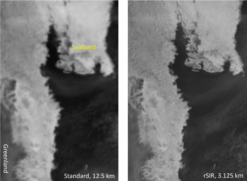
As the first year of research has finished, it is already receiving positive feedback from users at the National Weather Service Alaska Sea Ice Program in Anchorage. Greenwald noted that they appreciated being able to “see more fine-scale structure in the ice, especially the ice edge.” Greenwald plans to connect with potential users at the U.S. National Ice Center to provide further evaluations of the images and products.
As they move into the second year, the team will continue to focus on producing high spatial resolution images as close to real-time as possible. They will also transfer the processing software from CU to the supercomputer housed within the Space Science and Engineering Center at UW–Madison for testing before delivering the software to the NWS Arctic Testbed and Proving Ground. At the ATPG it will be tested extensively in an operational system. Ultimately, Greenwald looks forward to seeing the research transferred into operations, making the images and products available to forecasters on a routine basis.
Until then, Greenwald and his team will continue to improve the algorithms and software to produce more highly detailed images and more useful products. They will validate their work using data from other sources, such as the Visible Infrared Imaging Radiometer Suite in clear skies, and Synthetic Aperture Radar which is very high resolution, as well as Landsat.
Creating the products is important but training forecasters on how to use them is a crucial piece of this project. With that in mind, Greenwald has enlisted SSEC’s Scott Lindstrom to create training materials to teach users how best to use their products and images and their benefits. Broadening the reach of their research and sharing its value for forecasting and monitoring will be critical to its success.
As Greenwald notes, “The JPSS Proving Ground/Risk Reduction program is all about helping users, making sure they get the products that they need and eventually get these products into operations.”
Providing users with more detailed observations and images of Arctic sea ice will lead to better analyses of current ice conditions and forecasts for safer navigation by industry, as well as indigenous people.
This work is supported by NOAA.