New GOES Sounder Retrieval Algorithm Adopted by NOAA
An improved version of the GOES Sounder retrieval algorithm, developed at CIMSS by Jun Li and Zhenglong Li, has been implemented within the NOAA/NESDIS Office of Satellite and Product Operations (OSPO). The algorithm was also successfully reviewed by the NOAA/NESDIS Satellite Products and Services Review Board (SPSRB) and accepted for transition into OSPO operations within 45 days.
Although atmospheric researchers feel the critical need for new hyperspectral capabilities with geostationary sounders if resulting atmospheric profiles are to be obtained with sufficient vertical resolution to readily impact forecasters’ decisions, some CIMSS researchers and their colleagues have not abandoned the filter wheel radiometers of the current GOES Sounders.
The “Li version” (Li et al , 2008), which grew out of an evolving research-to-operations (R2O) effort over the last couple years, is a significant improvement over the current operational algorithm, the “Ma version” (Ma et al, 1999), also developed at CIMSS. The GOES Sounder retrieval products currently available to National Weather Service (NWS) forecasters on their AWIPS (Advanced Weather Interactive Processing System) workstations are from the Ma version.
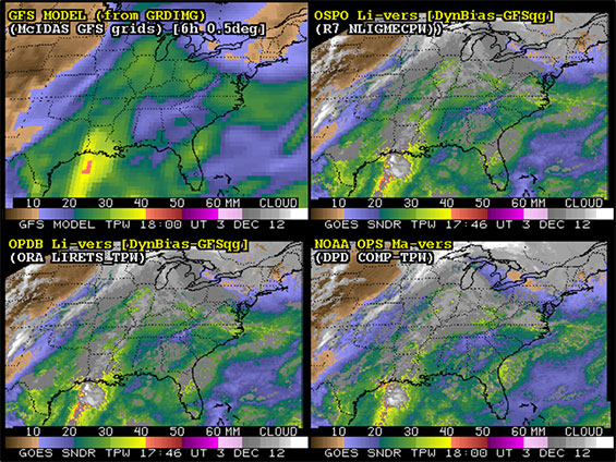
Example of GOES TPW DPI at 1746 UT on 03 December 2012 along with GFS model forecast first-guess. The right side, top image shows the new Li version (2008) produced by OSPO, while the right bottom image shows the old Ma (1999) version which is currently on AWIPS. Note how the new version handles clouds better (as across the central Great Lakes) and has less shot noise (as through the mid Mississippi Valley and Ohio Valley).
The R2O process started with implementation of the Li version on McIDAS here at CIMSS, and the establishment of routine real-time production and display. The next step was initial implementation of the Li version at the NOAA/NESDIS/STAR/SMCD Operational Products Development Branch (OPDB) in Maryland.
These research implementations, at both CIMSS and OPDB, were accompanied by evaluations of the products with other data sources, such as radiosondes, and other remotely sensed observations, such as the GPS-Met (Global Positioning System-Meteorological Satellite) data. Within the last year, NOAA/NESDIS/OSPO implemented, within their operational confines, the code provided from the NOAA/NESDIS OPDB.
Assessment of the quality of both versions (Ma and Li), and at all sites (CIMSS, OPDB, and OSPO), continued with an eye to demonstrate the improvement of the Li version over the Ma version, as well as to observe improvement of the retrieval over its first guess, derived from the Global Forecast System (GFS) numerical prediction model.
With an emphasis on moisture with the current GOES Sounders, the team focused on evaluation of the total precipitable water (TPW) from the GOES profiles, as well as with GPS-Met. On 19 December 2012, A. K. Sharma of OSPO presented the case to the SPSRB for the product enhancement of the operational GOES Sounder single-field-of-view (SFOV) products by the Li version to proceed into NESDIS operations.
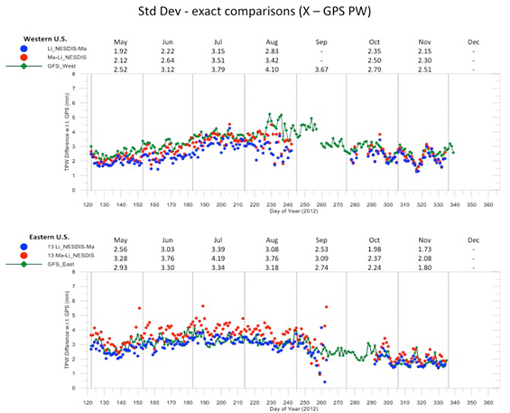
This figure shows the comparison of the standard deviation (SD) of the TPW from (1) the Li version, (2) the Ma version, and (3) the GFS first-guess, all compared to the GPS-Met TPW over about the last half year. These comparisons are for both the East US (with GOES-13) and West US (with GOES-15) coverage. Note that some satellite and processing anomalies occurred during periods from mid-August 2012 to mid-October 2012, and those results should be examined with caution.
Overall, the improvement of the Li version, over the Ma version, is obvious (consistently lower SD), and the betterment of the first-guess with the Li version is also generally clear (in only one month does the Li version SD not beat the guess SD, the result being nearly a tie).
Although the future GOES-R will have no sounding instrument, the Advanced Baseline Imager (ABI) does have multiple spectral bands, including three mid-wave water vapor channels (roughly similar to the current GOES Sounder). In addition, “legacy soundings” from GOES-R are to be made with the ABI as “Day-1” products.
Continued work with the current GOES Sounders remains relevant, as (1) the algorithm for the “legacy soundings” from the GOES-R ABI is essentially that of the Li version discussed here, and (2) the current GOES Sounders may last until close to the end of this decade (near 2020). Any improvements made with the retrieval algorithm or the forecast application of the retrievals, from the current GOES Sounders, should only help the effort with the GOES-R “legacy soundings.”
The many diverse groups and individuals intimately involved in this successful R2O task have included:
- CIMSS (WI): Jun Li and Zhenglong Li (algorithm development); James P. Nelson III, Anthony J. Schreiner, Timothy J. Schmit [ASPB], and Gary S. Wade [ASPB] (McIDAS implementation, production, display, and assessment); and Ralph Petersen, Richard Dworak, and Robert M. Aune [ASPB] (model and Nearcast sensitivity);
- NOAA/NESDIS OPDB (MD): Americo S. Allegrino and Jaime Daniels (OPDB implementation);
- NOAA/OAR/ESRL (Earth System Research Laboratory) (CO): Seth I. Gutman, Daniel L. Birkenheuer, and Kirk L. Holub (GPS-Met data and statistical comparison); and
- NOAA/NESDIS/OSPO (MD): Awdhesh Sharma and Truc Nguyen (OSPO implementation/SPSRB review).
More information and displays can be found at: http://cimss.ssec.wisc.edu/goes/rt/exp-work.php.