Monthly News Summary – August 2009
- First Images from GOES-14 Received
- CIMSS’ MODIS NDVI Helps National Weather Service Surveys
- High and Dry in Chile
- Mr. Batzli Goes to Washington
- CIMSS Represented at the ESIP Teacher Workshop
- Tropical Cyclones Group Awarded Two Grants
- Lake Mendota Buoy Project Part of Your iPhone
- July 2009 Outreach Events at AOSS
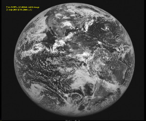
First Images from GOES-14 Received
On 27 July 2009, SSEC’s Data Center began receiving full disk visible band images from GOES-14 in its geostationary orbit at 90 degrees west longitude. Below is the first GOES-14 Imager full disk visible image, at 1730 UTC. The first infrared image, is scheduled to be received on 17 August 2009.
For more information go to the CIMSS Web site.
CIMSS’ MODIS NDVI Helps National Weather Service Surveys
On 24 July 2009, two severe thunderstorms producing large hail developed and moved across southwestern Wisconsin, heavily damaging the maturing corn and soybean crops in large swaths.
Later, when conducting aerial surveys to assess the extent of the damage, the National Weather Service (NWS) local office in Sullivan, Wisconsin, turned to one-kilometer MODerate Resolution Imaging Spectroradiometer (MODIS) Normalized Difference Vegetation Index (NDVI) imagery produced at the Cooperative Institute for Meteorological Satellite Studies (CIMSS). These images revealed a lesser amount of green in the vegetation, indicating damage to crops.
CIMSS has made useful MODIS imagery and products available in a non-operational capacity to NWS local offices nationwide since 2006, and these uses underscore the anticipated benefits from the Geostationary Operational Environmental Satellite R-Series (GOES-R).
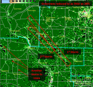
This figure, courtesy of the National Weather Service, shows decreased greenness fraction in swaths over southwestern Wisconsin following the passage of two severe hailstorms.
Dave Turner is the co-PI of the Radiative Heating in Underexplored Bands Campaign (with Eli Mlawer at Atmospheric and Environmental Research, Inc.). The RHUBC-II experiment is working to improve the measurement of the absorption of radiation by water vapor in the mid-troposphere, and thus improve the treatment of radiation in climate models.
The three-month experiment will be conducted at 5380 m (over 17,500 ft) in the Atacama Desert in northern Chile. The facility is currently being assembled, with the hope of beginning operations in mid-August.
Through October 2009, nearly a dozen instruments will operate continuously to obtain measurements such as temperature, pressure, humidity, and incoming and outgoing energy. In addition, a combination of several spectrometers will obtain measurements from the infrared region of the spectrum.
“Only three groups in the world make spectrally resolved radiance observations in the far-infrared [wavelengths longer than 15 microns] and two of those groups are in this campaign; the other participated in the first phase of the study in Alaska in 2007,” said Dave Turner. “But, perhaps more importantly, this is the first experiment that I know of that is making spectrally resolved measurements of downwelling radiation from 1 to 1000 microns in wavelength simultaneously.”
The lofty Chajnantor plateau is located west of the Andes in Chile’s Atacama desert, one of the driest places on Earth – 50 times drier than California’s Death Valley. Water vapor strongly absorbs solar and infrared energy in many bands throughout the electromagnetic spectrum and at normal surface locations can be essentially opaque in certain spectral ranges. At this location, these spectral regions where water vapor absorbs will be partially transparent. Thus, the accuracy of the models used to predict the absorption can be evaluated there.
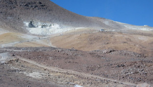
Instrument containers being moved up to the site (there are two white containers already there in the upper-right and the truck in the road is hauling another).
Detailed information obtained from this field campaign is expected to greatly reduce uncertainties in the treatment of middle and upper tropospheric moisture in the radiation calculations used in global climate models.
More information can be found at the Atmospheric Radiation Measurement (Program) site.
On 23 July 2009 the US House Committee on Natural Resources, Subcommittee on Energy and Mineral Resources heard testimony regarding the AmericaView Geospatial Imagery Mapping Program Act (H.R. 2489) from a panel that included SSEC’s Sam Batzli.
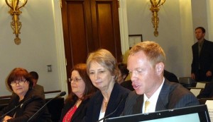
(L to R) Ms. Suzette Kimball, US Geological Survey Acting Director; Dr. Rebecca Dodge, AmericaView board member and TexasView co-investigator; Ms. Mary O’Neill AmericaView board member and SouthDakotaView director; SSEC’s Dr. Sam Batzli, AmericaView board member and WisconsinView director.
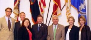
Pictured following the hearing are (L to R) Rick Landenberger, AmericaView Executive Directrr; SSEC’s Dr. Sam Batzli, AmericaView board member and WisconsinView director; Dr. Rebecca Dodge, AmericaView board member and TexasView co-investigator; Ranking Republican Member Doug Lamborn (R-CO); Chairman Jim Costa (D-CA); Ms. Mary O’Neill AmericaView board member and SouthDakotaView director; Rep. Stephanie Herseth Sandlin (D-SD) lead sponsor of H.R. 2489.
Details of the hearing including written testimony and video stream can be found on the House of Representatives Committee on Natural Resources site.
The video includes coverage of two back-to-back hearings. The AmericaView session begins at 1:31:25 (below is a guide to specific testimony).
1:41:00 * Suzette Kimball
1:46:40 * Rebecca Dodge
1:51:50 * Mary O’Neill
1:57:30 * Sam Batzli
2:05:30 * Question and answer session begins
2:07:20 * USGS response to question about bill language (changes,
modifications)
CIMSS Represented at the ESIP Teacher Workshop
The Cooperative Institute for Meteorological Satellite Studies (CIMSS) recruited presenters and participants for a teacher workshop held in conjunction with the 2009 Federation of Earth System Information Partners (ESIP) summer conference at the University of California – Santa Barbara (UCSB) on July 8th and 9th.
As a unique consortium of over 100 organizations that collect, interpret and develop applications for remotely sensed Earth science data, ESIP meetings are a perfect venue to connect K-12 educators with remote sensing scientists. With support from NOAA, participating G6-12 teachers attended the conference plenary presentations followed by an afternoon and second full day of workshop sessions that featured hands-on computer activities demonstrating ways that data and tools can be used in science classrooms. Sessions were led by ESIP members from NOAA, CIMSS, NASA, TERC and other ESIP organizations.
CIMSS presenters included Margaret Mooney and Tommy Jasmin. A total of twenty-nine attendees registered for the teacher track session of the conference, including Peggy Lubchenco, sister to NOAA administrator Dr. Jane Lubchenco. Workshop evaluations indicate that the debut event was a success with seventeen teachers rating the experience as “excellent”, the rest checked the next best box of “very good”.
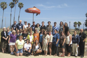
Submitted by Margaret Mooney
Tropical Cyclones Group Awarded Two Grants
The Tropical Cyclones Group was awarded two significant grants based on proposals to innovate and utilize satellite observations to study hurricanes.
The Physical and Dynamic Meteorology Program of the National Science Foundation has recommended a full award in response to the proposal “Characterizing Atlantic Tropical Cyclone Genesis using Special PREDICT Measurements and Satellite Observations/Products.”
In addition, the proposal “Achieving Superior Tropical Cyclone Intensity Forecasts by Improving the Assimilation of High-Resolution Satellite Data into Mesoscale Prediction Models,” has been recommended for funding as part of the Fiscal Year 2009 National Oceanographic Partnership Program (NOPP) Broad Agency Announcement.
Submitted by Chris Velden
Access the Lake Mendota Buoy Project on Your iPhone
1821 Design out of Illinois has created an application for the iPhone/iPod
Touch that reads data from the Lake Mendota buoy project and displays it.
The application is free and can be downloaded at the 1821 Design site.
July 2009 Outreach Events at AOSS
Dozens of groups and hundreds of individuals benefit from educational programs run by scientists and staff at the Atmospheric, Oceanic and Space Sciences building each summer. This article highlights a few programs from July 2009.
AOSS hosted the Teacher Training on Carbon Cycle and Climate Modeling workshop, led by AOS professor Dr. Galen McKinley in collaboration with CIMSS/SSEC. The workshop provided a carbon cycle-based overview of climate mechanisms and climate change. Participating teachers developed the skills and knowledge necessary to incorporate carbon cycle and climate modeling tools into their classrooms while simultaneously deepening their overall comprehension of the climate system.
There were also two sessions of Grandparents University (GPU) at AOSS this year. CCR ran the Climate Major and SSEC hosted alumni and grandchildren pursuing the Meteorology Major.
(GPU Meteorology Major July 2009. More pictures are available).
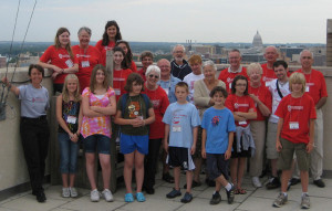
Last but not least, the 17th annual CIMSS student workshop took place at the end of July. Fourteen students enrolled with an even mix of girls and boys and in-state students perfectly balanced by out-of-state participants.
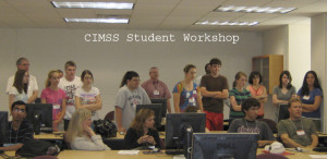
The five day science camp was led by Gary Wade and CIMSS Student Jordan Gerth. One glance at the jam-packed agenda reveals a pivotal theme of AOSS outreach programs: teamwork. Thanks to everyone who helped host and promote AOSS-based science to the numerous groups that visited this summer.
Submitted by Margaret Mooney