Monthly News Summary – July 2009
- GOES Sounder Product Improvements Noted
- GOES-11 Captures Smoke of Alaskan Wildfires
- National Hurricane Center Uses CIMSS Algorithms
- iPhone and iTouch Users Gear Up for Hurricane Season
- Record Temperatures in Montana Illustrated with MODIS
- Publications
GOES Sounder Product Improvements Noted
Recent developments in retrieval processing of Geostationary Operations Environmental Satellite (GOES) Sounder data provided increased accuracy in predicting the chances for severe convection events in Iowa and Southern Wisconsin.
Due to ongoing research through the GOES Improved Measurement and Product Assurance Plan (GIMPAP), a new version of the retrieval algorithm (known as Li(2008)), developed and implemented at CIMSS, continues to be assessed and compared with the previous (and current operational) algorithm (known as Ma(1999)).
Very extreme, and unreasonable, values of moisture and instability are often evident in portions of the Ma(1999) Derived Product Imagery (DPI), especially around cloud regions. Such deficiencies are decreased within the Li(2008) DPI.
On 23 June 2009, the Ma(1999) DPI showed extreme instability across southern Wisconsin and southern Iowa, while the Li(2008) DPI showed much less instability across southern Wisconsin, which was much more in agreement with only one solitary, weak severe event being reported in Wisconsin.
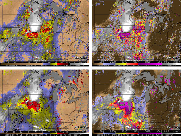
GOES Sounder DPI of Lifted Index (LI) on left, and of Convectively Available Potential Energy (CAPE) on right; where results on top are from the Ma et al (1999) algorithm version, and on bottom, from the Li et al (2008) version, for 20 UTC on 23 Jun 2009.
Click here for a full-size image.
GOES-11 Captures Smoke of Alaskan Wildfires
The 2009 wildfire season roared to life in Alaska on 02 July – 03 July 2009, with a number of very large and very intense fires breaking out across interior portions of the state. A ridge of high pressure was in place over the region, allowing Fairbanks to experience a high temperature above 80º F (27º C) on both days.
GOES-11 visible images showed some impressive smoke plumes developing on 02 July, especially from the fire located to the east-southeast of Fort Yukon (station identifier PFYU). Note the pulses of “pyrocumulus” that emanated from the “Little Black One” fire complex, as it raged over 19,000 acres of land.
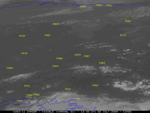
The large and dense smoke plume originating east of Fort Yukon continued to drift southwestward overnight, and had moved over the Anchorage area (station identifier PANC) by the morning hours on 03 July.
National Hurricane Center Uses CIMSS Algorithms
Key satellite intensity estimates derived by CIMSS objective algorithms, both the Advanced Dvorak Technique (ADT) and Advanced Microwave Sounding Unit (AMSU), have been used by the National Hurricane Center in their Tropical Cyclone Report to formulate the final analysis and “Best Track” on last year’s Hurricane Omar. This was the first time that the AMSU has been shown in this type of report.
The report concerning Hurricane Omar can be seen here. (Sections a and b and Figures 2 and 3 are of particular interest.)
iPhone and iTouch Users Gear Up for Hurricane Season
Satellite imagery from CIMSS is being used in a new hurricane tracking application distributed by Kitty Code for Apple iPhones and iPod Touch devices. According to a representative for the company, the images were chosen because “…they show more area than the other generally available infrared satellite images. And they’re pretty.”
The application, called simply “Hurricane,” is an interactive tracking map for the iPhone/iTouch which allows users to move between tracks, viewing each plot’s detailed information including wind speed with the icon, latitude, longitude, storm speed and direction, pressure, date and time in the tab bar. Users can also track hurricanes both past (back to 1851 in the Atlantic) and present.
Take a look at what the downloadable application offers to users here:
http://kittycode.com/products/hurricane/
Record Temperatures in Montana Illustrated with MODIS
The National Weather Service Glasgow station used a MODIS Land Surface Temperature image in the June 2009 issue of their “Under the Big Sky” newsletter sent out to their weather spotters and partners.
Read their newsletter here.
Tropical Cyclone Intensity Paper Accepted: A manuscript titled “Tropical cyclone convection and intensity analysis using differenced infrared and water vapor imagery,” by Tim Olander and Chris Velden (Cooperative Institute for Meteorological Satellite Studies, CIMSS), was accepted for publication in Weather and Forecasting. The paper outlines the relationship of the channel differencing product to tropical cyclone (TC) intensity changes, the qualitative use of the derived product imagery by TC forecasters to identify and monitor TC convection, and the potential integration within the CIMSS Advanced Dvorak Technique (ADT).
Paper Accepted for Publication in Monthly Weather Review: A paper entitled “The Impact of Satellite-derived Polar Winds on Lower-latitude Forecasts,” authored by Dave Santek, was accepted for publication in Monthly Weather Review. The paper examines how polar-only observations assimilated into a global model can impact the dynamics of the jet stream, which affects subsequent forecasts down to subtropical latitudes.
VHRR Cloud Climate Project Accepted by WMO Panel: The executive panel of the World Meteorological Organization’s Sustained Coordinated Processing of Environmental Satellite Data for Climate Monitoring (SCOPE-CM) initiative has accepted an Advanced Very High Resolution Radiometer (AVHRR) cloud climatology project coordinated by Andrew Heidinger. A total of five initial projects were accepted into the SCOPE-CM initiative. The AVHRR cloud project also involves several European scientists.