UPDATE: Satellite Images of the Winter Storm Hitting the US East Coast
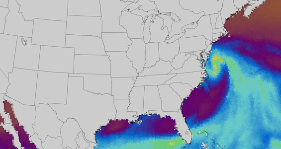
CIMSS/MIMIC, Total Precipitable Water graphic, 8 February 2013.
UPDATE: Visit the CIMSS Satellite Blog (scroll down) for MODIS and VIIRS images of the storm acquired on 09 February 2012.
Scientists from the Cooperative Institute for Meteorological Satellite Studies (CIMSS) used sophisticated imaging techniques to track the development of a major winter storm off the east coast of the United States on 8 February.
One product used, the Morphed Integrated Microwave Imagery at CIMSS (MIMIC) was developed at CIMSS. It is a data-blending technique that combines disparate swaths of microwave observations and moisture fields from polar orbiting satellites in order to create near-seamless animations of storm activity. This advanced method offers scientists the capability to see that moisture values for the region were in excess of 200% of normal for this time of year.
Read more about other imaging processes in use at CIMSS in the Satellite Blog entry on the east coast storm.