WisconsinView Offers Digital Elevation Models of Wisconsin Counties
With the cooperation and leadership of the Wisconsin State Cartographer’s Office (SCO) and the Wisconsin Department of Natural Resources Floodplain Mapping Group, WisconsinView is now offering downloads of Light Detection And Ranging (LiDAR) digital elevation models (DEMs) of available Wisconsin counties. Airborne LiDAR technology captures high-resolution data of surface elevation useful in a wide range of land management and research applications.
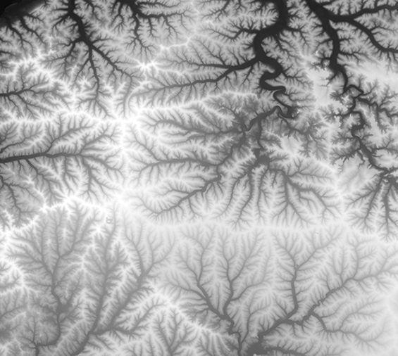
The DEM image above, created by Sam Batzli, the director of WisconsinView, shows the northeast corner of Grant County, Wisconsin. High elevations are indicated in white and low elevations are indicated in black. Military Ridge appears as a white line that runs east-west (right to left) across the bottom third of the image. Land north of the ridge drains into the Wisconsin River (barely visible in the upper left corner). Land south of the ridge drains into smaller rivers and then into the Mississippi. In addition to floodplain management, and land cover change analysis, these data are used to make shaded relief maps.
Currently, DEMs of 14 of 72 Wisconsin counties are available, with an additional seven to be added in the next few months; more counties will be included in the future. At this time only DEMs are available online. The LiDAR “point cloud” data from which this bare-earth (surface) elevation product is made is scheduled for later release.
Downloads are available in ESRI GRID format at the WisconsinView site. For more information about the LiDAR initiative see this SCO article.
Since 2004, WisconsinView, a federally funded program housed at SSEC and a member of the AmericaView Consortium, has focused on enhancing remote sensing data access and use across the state in support of research, education, and outreach. WisconsinView has made aerial photography and satellite imagery of Wisconsin available to the public free of cost over the web.