Grad Student Works to Improve Storm Prediction
UW-Madison graduate student Bill Line has scored the perfect job. Soon after receiving his Master’s Degree from the Department of Atmospheric and Oceanic Sciences in May, he will be heading to Norman, Oklahoma, where he will be the new Cooperative Institute for Mesoscale Meteorological Studies (CIMMS) Satellite Liaison at the NOAA/National Weather Service Storm Prediction Center (SPC).
As an undergrad, Line took a meteorology course from Professor Steve Ackerman who also directs the Cooperative Institute for Meteorological Satellite Studies (CIMSS) at UW-Madison. Central to the Institute’s mission is the pairing of students with CIMSS researchers. Noting that Line’s interest was running toward forecasting, Ackerman referred Line to veteran CIMSS scientist Ralph Petersen. Petersen, a pioneer in NearCasting, which covers the time between nowcasting (0-1 hours) and forecasting (beyond 12 hours), set Line to work on the development and improvement of the NearCasting model.
“The goal of the NearCasting model,” Line says, “is to improve predictions of the timing and location of hazardous weather events in the one to nine hour forecast range. The model uses temperature and moisture observations measured by the GOES sounder, a dataset that has been available for many years, but is still under-utilized.”
“I started working in the NearCasting area 10 years ago,” CIMSS Senior Scientist Ralph Petersen says. “We were looking at numerical models for storm forecasting. Those models used a grid over a given area, and each point of the grid had a set of dynamic equations using wind directions and speeds to calculate predictions. The equations were complex and took a long time to process, and the number of data points increased the possibility of error.”
Petersen developed a trajectory technique which, using satellite images of cloud location, could predict future cloud movement.
“But we started to see that severe weather formation happens vertically, not horizontally,” Petersen continues. “For severe weather prediction, we needed to see not only where the clouds may go, but where areas of potential instability were developing. We had to look into areas of clear sky to find the ingredients of storm formation.”
The original version of the NearCasting model dynamically projects the satellite observations forward in space and time along constant pressure surfaces, using Petersen’s trajectory approach. Line’s version of the model takes advantage of the fact that the flow of atmospheric moisture is three-dimensional, moving along isentropic surfaces that vary with pressure. This isentropic framework provides information of the vertical flows in the atmosphere, as well as the total moisture content in an isentropic layer, which can be used to predict the amount of precipitation that may occur.
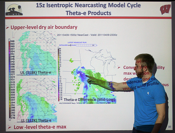
Bill Line explains his Master’s degree thesis presentation.
The satellite instrument measures radiation being emitted from different layers in the atmosphere. These radiances are used to acquire profiles of temperature and moisture. One of the difficulties in using these data, especially over land, is that the land surface itself emits heat, causing a background radiation that complicates the retrieval process.
The NearCasting model focuses on the relative values between atmospheric layers and on the horizontal distribution of moisture throughout the atmosphere. The vertical distribution of temperature and moisture is used to determine the stability of the atmosphere in the studied region.
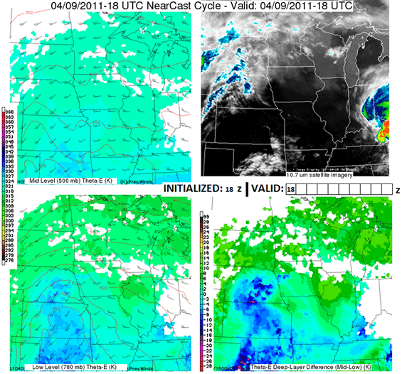
Animation of the nine hour isentropic NearCast model cycle initialized at 1800 UTC on 09 April 2011 with satellite imagery valid at the indicated forecast times. This cycle predicted a cool, dry air boundary at the upper level (low values of theta-e) to move over an ascending low-level temperature/moisture maximum (high values of theta-e) over eastern Nebraska and western Iowa between 2100 and 2300 UTC. This setup correlated to a rapid destabilization (theta-e difference values becoming more negative) of the deep layer. Satellite imagery confirms that strong convection began development in eastern Nebraska at about 2200 UTC, when/where the model had predicted a maximum in convective instability to be moving into several hours earlier.
“The model predicts where there will be warm moist air below cool dry air,” says Line. “In such a situation, the atmosphere is convectively unstable, and convection is most likely to occur in that region. The model is equally valuable in predicting the opposite situation of convective stability, which will inhibit convective development. ”
Convectively unstable areas are where severe storms may develop – the hot, moist air at the lower levels rises, swirling into the cooler, drier air above. The greater the vertical gradient of these properties, the higher the chance for storms.
“We see better data, using these isentropic surfaces,” Petersen says. “Using satellite infrared data in clear skies, we can see where the flow starts to lift. We can also better measure the moisture in the clouds, showing us not just where severe weather is going to happen, but also where we might have heavy rain. It’s also important to remember that we are not just predicting where convection may occur and cause storms. We are also predicting where convective events will not happen. Avoiding false alarms is almost as important, in the long run, as broadcasting dependable early warnings.”
“It has been tested at the Hazardous Weather Testbed, at the SPC, and in Kansas City at the Aviation Weather Testbed,” Line says. “We are getting lots of positive feedback from the forecasters who are trying it out. The ultimate goal will be to get forecaster acceptance.”
Line is eager to work with forecasters more closely and make this goal a reality; he starts his new job in Oklahoma on the Monday after he receives his Master’s degree.