Hurricane Monitoring in 2013: Improving the Tools and Our Understanding
As the U.S. braces for this year’s hurricane season (officially June 1 – November 30), CIMSS scientists are gearing up with a number of research projects designed to provide more insight into tropical cyclones and how they are formed. Additionally, they are working to demonstrate and improve satellite-derived products used both experimentally and operationally at the National Hurricane Center, as well as provide the tools necessary to investigate possible climate trends in hurricanes.
Summer 2013 ushers in Year 2 of the NASA-led Hurricane and Severe Storms Sentinel (HS3) field campaign, designed to study hurricane formation and intensity in the Atlantic Ocean Basin. Two Northrop Grumman-designed Global Hawks, unmanned aircraft carrying a variety of sensors and dropsondes, will be available during the peak of the season to gather data, with one Global Hawk targeting the inner core of the storm itself and a second targeting the storm’s environment. CIMSS researchers Derrick Herndon and John Sears will travel to the HS3 operations base at Wallops Island, Virginia to prepare forecasts during the field campaign, while CIMSS Senior Scientist Christopher Velden will serve as a mission scientist for a week.
Velden noted that CIMSS scientists will play a more active role in this year’s HS3 campaign. In addition to preparing forecasts, they’ll specifically monitor possible hazards in the Global Hawk’s flight path during missions – ensuring that the aircraft stays safe while allowing the sensors onboard to gather as much useful data as possible. Given the aircraft’s flight restrictions with regard to over-flying active convective systems, this year the field campaign will have new satellite-based guidance tools based on GOES imagery. One example is an advanced cloud height estimation algorithm/product developed by Andy Heidinger, a National Oceanic and Atmospheric Administration (NOAA) scientist stationed at CIMSS. Complementing this is a product developed by former CIMSS scientist Kris Bedka (now with Science Systems and Applications, Inc), and adapted to the tropics by CIMSS researcher Sarah Monette, that will allow mission monitors to detect convective overshooting tops, which the Global Hawks need to avoid.
With a start date of 20 August 2013, HS3 is scheduled to last five weeks this summer. The final year of the three-year field campaign will take place in summer 2014.
In addition to gathering new data during this field campaign, CIMSS scientists are eager to demonstrate the future capabilities of the next generation geostationary satellite, GOES-R, set to launch in 2015. For example, special GOES-14 data that was made available by NOAA/NESDIS during Hurricane Sandy in 2012 is being used to simulate the sampling of GOES-R to see if the hurricane’s forecast could be improved. GOES-14 was operating in super rapid scan mode during Sandy, which meant new data was sampled every one minute (as would be available with GOES-R) rather than the typical 15 minutes with the current GOES. One product sure to benefit from this increased temporal resolution is cloud-motion vectors as demonstrated in the figure below.
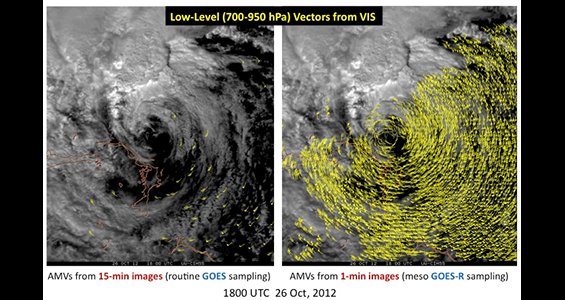
Atmospheric Motion Vectors from special GOES-14 super-rapid-scan operations during Hurricane Sandy. (Image courtesy of Dave Stettner and Chris Velden (CIMSS))
CIMSS scientists will also have the opportunity to demonstrate upcoming experimental products for hurricane forecasters at the National Hurricane Center (NHC) as part of the NOAA/NESDIS GOES-R Proving Ground activities. Similar in purpose to the Hazardous Weather Testbed last month (although with a different focus), the NHC Proving Ground (NHC-PG) serves as a real-time virtual demonstration of newly developed products designed to simulate what will be available from GOES-R and allows algorithm/product developers to get valuable feedback. Velden notes that in past years some of the products made available to the forecasters during the NHC-PG have been adopted and used in operational forecast discussions. For example, the objective satellite-based Hurricane Intensity Estimation (HIE) algorithm developed for GOES-R real-time applications by CIMSS researcher Tim Olander has been cited on several occasions as being helpful in determining hurricane strength.
Getting new, improved products into the hands of hurricane forecasters is critical for advancing their ability to monitor tropical storms. Jim Kossin, a scientist with NOAA’s National Climatic Data Center (NCDC) stationed at CIMSS, mentioned two success stories from his own research collaborations focusing on improving hurricane intensity forecasts. The first tool “predicts the onset of the eyewall replacement cycle, which signals rapid changes in [hurricane] intensity and size.” Kossin commented that Hurricane Katrina clearly demonstrated this very phenomenon. Whereas forecasters once lacked an objective way to predict these rapid changes, they now have a “probabilistic model that [gives] the likelihood” of such transformations within the hurricane. The second tool provides forecasters with a probability that a hurricane will undergo rapid intensification. Kossin was quick to note that he and his collaborators are continuing to make improvements to these operational tools.
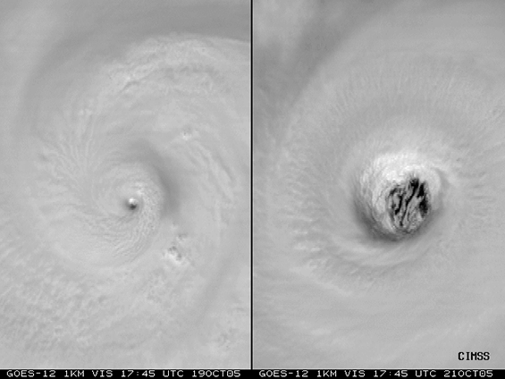
GOES-12 images of 2005 Hurricane Wilma. The left image shows Wilma on Oct 19 with a “pinhole eye” near the time of maximum intensity. Wilma then went through an eyewall replacement cycle and became a much larger storm. The right image shows Wilma 2 days later, just prior to making landfall in Mexico. (Image courtesy of Jim Kossin (NOAA/NCDC))
While helping to create accurate hurricane forecasts remains a priority, a growing area of research is the connection between tropical cyclone activity and climate change. A marked increase in Atlantic tropical cyclone activity has been noted since 1995. As scientists investigate possible trends and search for causes, one concern has been the historical hurricane data and its lack of consistency. Kossin originally collaborated with Ken Knapp (NOAA NCDC) to create a new consistent hurricane satellite data record (HURSAT) that would allow users to estimate hurricane intensity globally. Kossin noted that “our mantra [for HURSAT] was consistency first, accuracy second.” So while the data record would be useful for trends and averages, it was less than ideal for examining specific hurricane cases.
Recently, they have developed a new, improved data record known as ADT-HURSAT to address that problem. The ADT-HURSAT uses the Advanced Dvorak Technique (ADT) developed by Olander and Velden (CIMSS) for estimating hurricane intensity. An article describing ADT-HURSAT is in review for the Journal of Climate.
Kossin is also actively involved in international and national groups assessing the current state of climate change and climate change research. As a participant on the Intergovernmental Panel on Climate Change (IPCC) he is serving as one of the lead authors on a chapter titled “Climate Phenomena and their Relevance for Future Regional Climate Change” in the IPCC’s Fifth Assessment Report scheduled to be released in late 2014. He’s also a lead author in the National Climate Assessment (part of the U.S. Global Change Research Program).
Both efforts rely on a process of “detection and attribution” (D&A). Kossin summed up detection as seeking out changes and trends that are not considered a result of natural variability and attribution as determining what the changes and trends can be attributed to. Kossin described the D&A research as a combination of “data work, modeling work, and theoretical work.” He also noted that to date scientists are divided on the dominant cause of increased tropical storm activity in the Atlantic Ocean, with half citing pollution and greenhouse gases and the other half citing natural variability (although most in this group acknowledge that pollution is likely playing a measurable role).
Given the destructive nature of tropical cyclones, and hurricanes in particular, seeking the answers to how and why they form and creating the tools to help forecasters analyze and monitor them are essential areas of research, research in which the CIMSS tropical cyclone researchers are playing a vital role. And while activity in the Atlantic Ocean may soon begin to heat up, the work to improve our understanding of tropical cyclones will continue long after the last storm of the season dissipates.
by Leanne Avila