Monthly News Summary – April 2008
Views of the globe: The debut of a new outreach exhibit
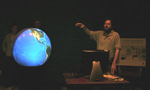
Tim Schmit (SSEC at NOAA) talks about remote sensing and satellite meteorology. Schmit uses the new SSEC globe to illustrate his talk.
On April 5, more than 500 visitors learned about different applications of remote sensing technology. As a part of a campus-wide science outreach event, SSEC hosted an open house with many engaging displays and activities, including the new globe display. The 3-D sphere facilitates a more concrete explanation of satellite-based observations of the Earth and its atmosphere.
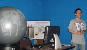
Howard Berger also used the globe to help visitors understand remote sensing concepts as well as atmospheric science basics.
Throughout the open house, SSEC scientistsHoward Berger andTim Schmit (NOAA at SSEC) used the globe to talk about environmental satellites. Part of the series of animations on the globe illustrates the differences between geostationary and polar orbiting satellites as well as why both types of satellites are useful to researchers and forecasters. The second portion of the presentation covered different types of observations made by satellite instruments and how scientists use that information to understand different characteristics of the planet.
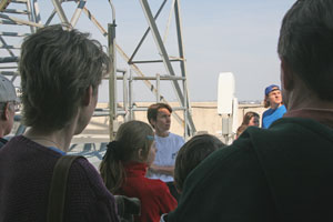
Margaret Mooney took visitors up to the roof of SSEC’s 16-floor building. During the roof tours, Mooney described the many instruments on the roof as well as SSEC’s role in the development of satellite meteorology.
Berger and Schmit also covered SSEC co-founder Verner Suomi’s contributions to the field of satellite meteorology. Suomi developed and was instrumental to the completion of the initial concept for a geostationary environmental satellite. SSEC views the 3-D globe as the first step to creating an atmospheric science museum named in honor of Verner Suomi’s accomplishments.
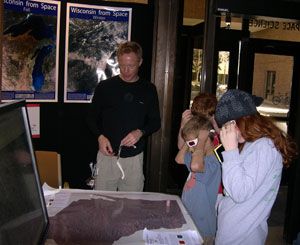
Sam Batzli had an exhibit in the lobby that displayed satellite images of Wisconsin.
In addition to exploring the Earth and satellite meteorology using the globe, visitors also had the opportunity to learn much more with a variety of exhibits set up in the lobby. Tom Whittakerhelped kids “Explore the Atmosphere” with a set of computer applets that teach the basics of atmospheric science. Tim Olsen taught visitors about severe weather using mapping software.Sam Batzli displayed satellite and aerial views of Wisconsin, including a few 3-D maps. Hsuan Piset up an activity to explain how scientists learn about other planets. However, visitors seemed most excited by Margaret Mooney’s tours of SSEC’s roof. While learning about the different rooftop dishes and instruments, participants took in a view of the city from the top of SSEC’s 16-floor building.
SSEC received partial funding for the globe through a grant from Ira and Ineva Reilly Baldwin Wisconsin Idea Endowment. Madison Gas and Electric sponsored the future installation of a solar panel to power the globe, creating a tangible representation of the connection between the Earth and the sun. The solar panel will also facilitate conversations about energy conservation and sustainable living.
A different perspective of Wisconsin
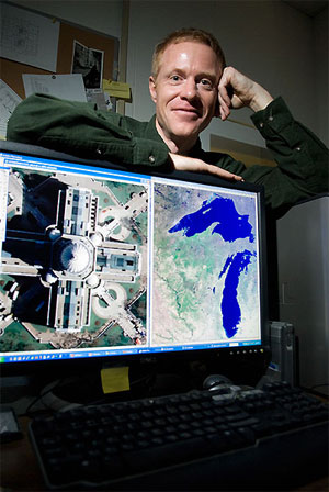
photo credit: Jeff Miller, University Communications
Sam Batzli is the director of WisconsinView, a free online service that provides access to images and data of Wisconsin. In this image, Batzli’s computer displays an image of the state Capitol (left) and a LandSat image of Wisconsin.
From his 12th-floor office, Sam Batzli has a view of nearby Lake Mendota and Madison’s downtown punctuated by the state Capitol. But instead of looking out the window, Batzli looks at Madison and the rest of Wisconsin from much higher altitudes.
Batzli is the director ofWisconsinView, a federally funded program that offers a free Web service for easy access to a variety of statewide images and data. “We basically provide a shortcut,” Batzli says. “WisconsinView offers free access to public domain data sets that would otherwise be difficult or expensive to acquire.”
Taken by cameras and sensors aboard airplanes and satellites, images in the archive managed by Batzli help utility companies determine the best place for a power line or water main. Dairy farmers rely on information from Batzli to select good grazing pastures. Even Wisconsin’s weekend warriors rely on Batzli’s databases to assess hunting grounds and plan hiking expeditions.
“It’s crazy — you wouldn’t believe how many uses there are,” Batzli says. “These images help those who need more than just a coarse snapshot.”
Thanks to Batzli, anyone who wants a different look at Wisconsin can easily browse close to 2,000 gigabytes of perspective.
WisconsinView has nearly 5,000 registered users from around Wisconsin and beyond, with new users registering every day. Led by UW–Madison, WisconsinView is part of a nationwide effort called AmericaView. In addition to his role as the director of WisconsinView, Batzli also serves on theAmericaView Board of Directors.
Read the entire profile as featured in Wisconsin Week on April 09.
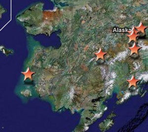
During the radio show, Tim Olsen also discussed using GPS and GIS technology to create maps that users can query. This map was a part of theMapTEACH project, which combined local knowledge of Alaska with modern technology.
What the heck is GPS?—Tim Olsen unraveled the mysteries of Global Positioning System technologies and uses on a radio program that aired on April 03. Speaking with WORThost Jim Carrier, Olsen started the show with a brief description of how GPS works. According to Olsen, a GPS device receives a signal from a network of satellites. The network can determine the location of the device depending on how long it takes for the signal to reach different satellites. Olsen says that the system is accurate within about 15 feet. Carrier and Olsen then discussed different uses for GPS, including: tracking systems for city ambulances and snowplows, monitoring factors for natural disasters, and high-tech games of hide-and-seek. To round out the show, Carrier and Olsen discussed the privacy issues brought about by GPS. Visit the WORT web site to find the archived recording of the show.
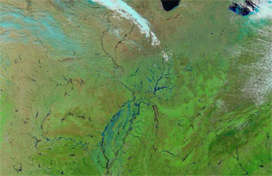
The swollen rivers in the central U.S. are clearly visible in this image from March 20.
Earth from above—From an ice shelf on the move to dust blowing across the Midwest, satellites illuminate Earth’s activities from a unique perspective. SSEC research meteorologist Scott Bachmeier uses satellite images to illustrate different interesting environmental case studies that he posts on the CIMSS Satellite Blog.
On March 10, Bachmeier posted images of the Wilkins Ice Shelf. The ice shelf began to collapse in late February. Bachmeier took advantage of SSEC’s resources to show readers the extent of the collapse. Shelley Knuth is a researcher with SSEC’s Antarctic Meteorological Research Center. Knuth provided Bachmeier with an image of the collapsing ice shelf as captured by an instrument aboard NASA polar orbiting satellites.
The same instrument, the Moderate Resolution Imaging Spectroradiometer (MODIS), yielded images of rivers and lakes flooding central U.S. A “false color” filter applied to the image accents the flooding. A time series of MODIS images shows the change in rivers between November 2007 and late March 2008. Melting snow and heavy precipitation contributed to this springtime flooding.
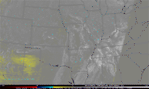
Dust from the southern U.S. traveled to the skies above Wisconsin with the help of a mid-latitude cyclone.
Geostationary satellites also provide information about the Earth and its atmosphere. In a post on April 11, Bachmeier discussed dust that traveled to Wisconsin from the southern portion of the U.S. Satellite images show a large plume rolling across the Great Plains on April 10. The dust continued northward in the circulation associated with large mid-latitude cyclone. In addition to highlighting different satellite observations of the dust plume, Bachmeier posted photographs of dirty snow received by the Green Bay National Weather Service forecast office.
Also of Note
NASA awards local scientists—NASA recently presented a Group Achievement Award to the GOES-N Series Team, which includes Tim Schmit (NOAA at SSEC) and Paul Menzel. This team worked on GOES-N/13, an advanced weather satellite launched in 2006 that now lurks in in-orbit storage. Schmit served as a co-coordinator of the post-launch tests of the satellite in December 2006. He and a cadre of colleagues analyzed observations from the GOES-13 sounder and imager to determine if the instruments functioned properly. The satellite will wait in in-orbit storage until one of the U.S.’s current GOES satellites fails.