Monthly News Summary – February 2008
A new way to look at the weather
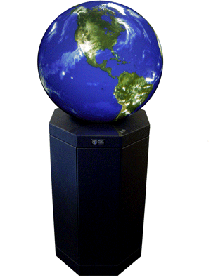
SSEC will have a similar globe for educational activities.
Image Courtesy of Global Imagination
Visitors to SSEC will soon have the opportunity to explore the Earth and its atmosphere on the Center’s new 3-D interactive globe. The globe will debut during an open house as a part of aUW-Madison campus-wide science outreach event on April 5.
SSEC received funding for the globe from the 2008 Ira and Ineva Reilly Baldwin Wisconsin Idea Endowment. Madison Gas and Electric sponsored the installation of a solar panel to power the globe, creating a tangible representation of the connection between the Earth and the sun. The solar panel will also facilitate conversations about energy conservation and sustainable living.
By interacting with satellite data on the globe, visitors will gain a better understanding of how environmental satellites provide unique, complex information about our planet. Using special data sets, visitors will also have the chance to check out what the current weather looks like from space and to explore the atmospheres of other planets.
As a part of the Baldwin Grant, SSEC will provide travel stipends to school groups around the state. To reach even more people, the globe will spend time at the Madison Children’s Museum, UW’s Space Place, the Milwaukee Public Museum and the Experimental Aircraft Association in Oshkosh.
The key to quieter hurricane seasons may be blowing in the wind
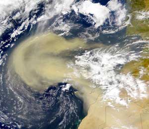
Dust blowing off the West Africa decreases the temperature of the Atlantic Ocean.
Every year, storms over West Africa disturb millions of tons of dust and strong winds carry those particles into the skies over the Atlantic. According to a recent study led by University of Wisconsin-Madison atmospheric scientists, this dust from Africa directly affects ocean temperature, a key ingredient in Atlantic hurricane development.
“At least one third of the recent increase in Atlantic Ocean temperatures is due to a decrease in dust storms,” says lead author Amato Evan, a researcher at UW-Madison’s Cooperative Institute for Meteorological Satellite Studies (CIMSS).
The team of scientists describes how dust in the atmosphere cools the ocean by decreasing the amount of energy that reaches the water. The study also demonstrated that the large amount of dust blowing off of Africa in the 1980s and ‘90s likely cooled the Atlantic enough to prevent conditions that could have resulted in more devastating hurricane seasons similar to 2004 and 2005.
Connecting research to applications:Weather aficionados meet up with colleagues in New Orleans
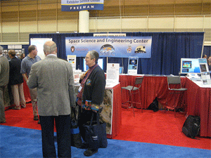
SSEC featured a variety of products in the Exhibit Hall. Several visitors stopped by to check out McIDAS-V and MODIS Google Earth displays.
The 88th annual meeting of the American Meteorological Societywas held in New Orleans will be remembered for a handful of noteworthy characteristics. The meeting had record attendance with more than 3,300 participants. Attendees took advantage of opportunities to directly help our host community by working with the New Orleans Habitat for Humanity effort. A popular Presidential Forum focused on Hurricane Katrina. Many New Orleans residents got involved by attending WeatherFest, the outreach portion of the annual meeting. Many sessions focused on the annual meeting theme “Enhancing the Connectivity between Research and Applications for the Benefit of Society.”
SSEC Highlights from AMS 2008
- Jim Kossin was a member of a panel of distinguished tropical cyclones researchers who discussed and debated the connection between climate change and tropical cyclone activity.
- Tommy Jasmin engaged an audience of educators by offering unique New Orleans keepsakes as prizes for correct answers to remote sensing questions.
- Tom Whittaker ran from room to room contributing to many activities, including serving as session co-chair for a session on using technology in education and one on challenges with data management.
- SSEC Director Hank Revercomb conveyed the importance of including high spectral and high temporal resolution imaging sounders on future satellites.
This theme will continue to shape our weather, ocean, climate, and environmental enterprises for many years to come. All elements of the AMS family—academia, the private sector and government—engaged in discussions or how we might enhance the mutual interactions between research and applications.
SSEC had a strong presence at the meeting, with over 40 participants and presentations. SSEC Senior Scientist Chris Velden served as one of the meeting’s Program Co-Chairs and helped liven up the event by suggesting the AMS hire local jazz bands to play during selected events. SSEC hosted its traditional display booth in the Exhibit Hall, and also participated with a booth at the WeatherFest. All in all, it was a very successful and enlightening meeting.

lCDS designed and built the Deep Ice Sheet Coring (DISC) drill. A crew from ICDS used this drill to take the first 1,900 feet of ice core at the West Antarctic Ice Sheet divide.
Returning from the ice—After several weeks of enduring cold, snowy conditions in Antarctica, SSEC scientists, engineers and drillers recently returned to similarly unpleasant weather as winter took a few more shots at Wisconsin. This year, two SSEC teams went to the end of the world: a team to take samples of the ice two miles beneath the surface, and a group to check on the Automatic Weather Stations.
SSEC’s Ice Coring and Drilling Services (ICDS) sent several drillers, engineers and other personnel to Antarctica to participate in the inaugural season of the West Antarctic Ice Sheet Divide Ice Core Project. ICDS designed and built a drill specifically to gather samples of the ice far below the surface. The ICDS team used the Deep Ice Sheet Coring (DISC) drill to cut the first 1,900 feet of core during this season. Over the next three seasons, the group will complete the two-mile core sample, which will allow scientists to piece together climate history year by year for the past 40,000 years.
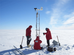
SSEC researchers work on the Schwerdtfeger AWS.
Researchers with SSEC’s Antarctic Meteorological Research Center and Automatic Weather Stations program also spent time in Antarctica this winter. The group replaced parts on the Automatic Weather Stations (AWS) and had to dig a few of the stations out of the snow. Shelley Knuth reported digging out one station that was buried under six feet of snow. The researchers also spent a lot of time in the lab at McMurdo Station working on AMRC’s computers.
Winter in Wisconsin—After a slew of less than impressive winters, record amounts of snow continue to bury Wisconsin. When the count toped 77 inches in mid-February, this winter officially became the snowiest on record. The city is well on its way to cementing that record with a few weeks of winter left. Scott Lindstrom illuminated many weather facts for theIsthmus’s David Medaris. Lindstrom reported that this winter has a chance of breaking more records ranging from snowiest month to most consecutive days with at least an inch of snow on the ground.
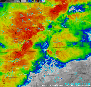
At least 80 tornadoes formed in the southern portion of the U.S. on February 5.
Before setting the record for snowfall, this winter in Wisconsin gained noteworthy status astornadoes touched down in the southern portion of the state. Wisconsin enjoyed unseasonably warm temperatures in early January 2008 as a warm, moist, unstable airmass settled over the Midwest. Ahead of the stationary front, severe thunderstorms produced damaging winds and hail. These relatively unusual conditions fostered the development of two tornadoes that occurred in Wisconsin on January 7: an EF-1 in Kenosha County and an EF-3 in Walworth County.
Tornadoes also tore across the southern portion of the United States on February 5. At least 80 tornadoes formed with some causing EF-3 and -4 damage. 58 related deaths were reported, making this event one of the 15 deadliest tornado outbreaks on record in the U.S.
Adventures in Green Bay—Since spring 2006, SSEC has provided satellite data in a format that’s easy for National Weather Service (NWS) forecast offices to use. In January, several SSEC delegates visited theforecast office in Green Bay to meet with more than a dozen NWS personnel. The group from SSEC talked with operational forecasters about a variety of topics, including: the ways in which forecasters use satellite data and images, applications of currently available data, and interest in new products. The SSEC convoy has found that NWS forecasters have a growing interest in satellite data products and use the available products in an operational setting with success.
Observing fires from space—CIMSS remote sensing experts report a record fire season in South America. Fire activity on the continent increased by 64 percent in 2007 compared to 2006, and showed an average increase of 45 percent over the preceding seven years. CIMSS scientists obtained these statistics using a computer technique that uses satellite data to assess fire activity, the UW-Madison Wildfire Automated Biomass Burning Algorithm (WF_ABBA). In addition to noting the trends in South America, researchers used the WF_ABBA to determine that overall fire activity in the Western Hemisphere increased by about 50 percent.