Monthly News Summary – January 2008
Recipe for a storm: The ingredients for more powerful Atlantic hurricanes
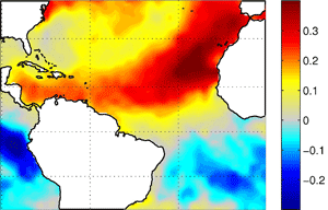
As the world warms, the interaction between the Atlantic Ocean and atmosphere may be the recipe for stronger, more frequent hurricanes.
UW-Madison scientists have found that the Atlantic organizes the ingredients for a powerful hurricane season to create a situation where either everything is conducive to hurricane activity or nothing is — potentially making the Atlantic more vulnerable to climate change than the world’s other hurricane hot spots.
After the 2004 and 2005 hurricane seasons, many worry what Atlantic hurricane seasons will look like in a warmer world. Evidence indicates that higher ocean temperatures add a lot of fuel to these devastating storms.
In a paper published on Nov. 29, in the Bulletin of the American Meteorological Society, co-authors Jim Kossin and Dan Vimont caution against only looking at one piece of the puzzle. “Sea surface temperature is a bit overrated,” says Kossin, an atmospheric scientist at SSEC/CIMSS. “It’s part of a larger pattern.”
Read the full UW-Madison news release.
SSEC provides satellite images in Google Earth
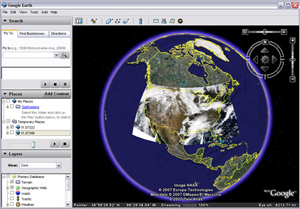
Google Earth users can now access the most recent high-quality satellite images generated at SSEC.
Satellite images provide a dramatic view of the Earth and its atmosphere. For timely views of winter weather in Wisconsin or wild fires in California, Google Earth users can now access the most recent high-quality satellite images generated at SSEC.
Unlike other satellite images accessible in the Google Earth interface, the center’s images show the natural colors of the Earth’s surface, and are available less than one hour after receiving the data from the satellite instrumentation. The images are made possible by the direct broadcast antenna on the SSEC building’s rooftop.
You can download Google Earth for free here:http://earth.google.com/
SSEC has two types of satellite images formatted for use in Google Earth: High-resolution images of the United States and coarser resolution images that cover more of the globe. Using the Google Earth interface, users see the latest satellite views of the Rockies before a skiing trip or of the latest storm brewing over the ocean.
A sampling of the blogs that featured SSEC’s Google Earth data:
Available as a free download from Google, Google Earth is a powerful, interactive tool that allows users to access a wealth of geographic information and imagery from a personal computer. To access SSEC’s data in Google Earth, simply click on the appropriately labeled files on the SSEC Google Earth repository and Google Earth will open automatically.
Several blogs and Google Earth galleries posted entries about SSEC’s images. The Wisconsin State Journal published an article about the Google Earth data sets.

The ICDS drilling crew tested the DISC drill in Greenland during 2007. Over the last few months, scientists, engineers and drillers have been in Antarctica for the inaugural drilling season.
During November and December, several SSEC employees packed up and went south for the winter. Unlike migratory birds following a similar trajectory, the SSEC scientists and engineers weren’t headed for warmer weather. Instead, they were on their way to one of the coldest, harshest places on the planet—Antarctica.
One of the SSEC Antarctic teams had to set up a large ice drill that will gather samples of the ice more than two miles beneath the surface. Drillers and engineers with SSEC’s Ice Coring and Drilling Services(ICDS) spent this winter at the West Antarctic Ice Sheet (WAIS) Divide. Using ICDS’s new Deep Ice Sheet Coring (DISC) drill, the team will continue to collect ice core over the next three Antarctic seasons. By analyzing the gases, dust, ash, and other substances trapped in the layers of ice formed from annual snowfall in Antarctica, scientists can reconstruct Earth’s climate thousands of years into the past.
The AMRC crew waits for the weather to improve so that an airplane can take them to the South Pole. George Weidner is holding Jelly Bear.
SSEC’s Antarctic Meteorological Research Center (AMRC) also sent a crew to Antarctica. These researchers plan to visit several Automatic Weather Stations to repair and perform regular maintenance on these crucial contributors to our understanding of Antarctic weather. The team will also check on the computers that AMRC has at stations on the continent. The AMRC group has a special guest for this trip to the ice: a stuffed bear from a group of Madison-area second graders. The students will learn about geography based on where the bear travels.
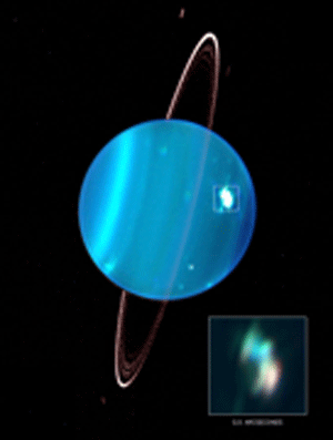
Sromovksy’s image of Uranus appeared on the cover of the December issue of Icarus.
Monitoring the clouds over Uranus—Learning about the atmospheres of other planets helps us understand more about our universe and about our own planet. A team led by SSEC’s Larry Sromovsky uses an advanced telescope in Hawaii to gather observations that provide information about the outer planets’ atmospheric compositions and cloud structures. Recently,Icarus, a planetary science journal, featured Sromovsky’s paper about the brightest cloud feature observed on Uranus. Icarus used one of Sromovsky’s images of the planet on the cover of that issue.
The cover image (shown right) is a color composite adaptive optics image of Uranus, made on 15 August 2005 using the Keck II telescope and NIRC2 camera. Filters K’ (1.95-2.3 microns), H (1.49-1.78 microns), and J (1.17-1.33 microns) were assigned to red, green and blue color components respectively. The complete image is enhanced to show normal features on the full disk while the inset is enhanced to show the structure of the 30 deg N Bright Complex, which is the brightest cloud feature ever observed on Uranus and is saturated in the full-disk image. At its observed peak in the K’ band, the feature was 100 times brighter than the background atmosphere and responsible for 13 percent of all the light reflected by the planet. During an eleven-month span of observations, the feature also exhibited non-uniform motions and variations in altitude and effective area.
Zooming in on Wisconsin—SSEC’s Sam Batzli recently added one-foot resolution aerial orthophotography imagery of Madison, Kenosha and Racine to the geospatial information available through WisconsinView. WisconsinView provides satellite imagery of the state to registered users. Registering with WisconsinView is free and opens a portal to many types of geospatial data.
Weather resources for cross-country skiers—Those who itching to strap on a pair of skis and glide across the snow covered countryside have a friend in SSEC research meteorologist Scott Bachmeier. Bachmeier has a passion for weather and also enjoys cross-country skiing. Combining these two interests, Bachmeier created a web site that contains a wealth of weather information that might be useful to those planning to traverse the snow on skis. In late November, David Medaris of the Isthmus wrote about Bachmeier’s site.
CIMSS Director inspires undergrads—When he isn’t wrangling CIMSS scientists, advising graduate students or pouring over satellite data, CIMSS Director Steve Ackerman teaches a popular basic atmospheric science class. This class usually accommodates a few hundred undergraduates. Ackerman has a reputation for being able to engage and inspire this large group. He comments on his philosophy and strategy for this class in an article in the Wisconsin State Journal on November 26, 2007.
Hurricane season recap—The Atlantic 2007 hurricane season came and went quietly. A few named storms doted the summer months, but the season paled in comparison to predictions. Amato Evan provided many media outlets with commentary throughout the Atlantic hurricane season. Evan has conducted research on the effects of dust from Africa on Atlantic hurricane activity. A reporter from the Philadelphia Inquirer focused on Evan’s research in a post mortem discussion of the Atlantic hurricane season. The discussion appeared in the newspaper’s weather blog in December.
Review of Storm World—Hurricane researcher Jim Kossin reviewed Chris Mooney’s Storm World: Hurricanes, Politics, and the Battle Over Global Warming for American Scientist. Storm World details the evolution of hurricane research and connections to climate change. In the book, Mooney references research led by Kossin. This research provides scientific evidence that hurricanes have become stronger and more frequent in the Atlantic Ocean over the last two decades.
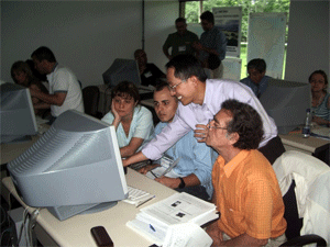
Allen Huang helps workshop particpants during an interactive lab session.
Forecasting in South America—Participants from twelve countries traveled to São Paulo, Brazil for a weeklong remote sensing workshopcoordinated and taught by a team from SSEC/CIMSS. Allen Huang, Tom Rink, Tim Schmit (NOAA at SSEC), Kathy Strabalaand Gary Wade(NOAA at SSEC) guided participants through lectures on remote sensing fundamentals and hands-on labs that applied concepts from lectures to actual data. In addition to gaining the skills to use remote sensing data for environmental applications, the workshop fostered the development of a network among the participants that will facilitate the exchange of data and information in the future. Significant contributions from NOAA made this workshop possible.
Distinguished SSEC scientists elected SPIE fellow— The Society of Photographic Instrumentation Engineers (SPIE) recently elected SSEC’sAllen Huang to be an SPIE fellow. To be distinguished as a fellow, SPIE looks at a candidate’s achievements and outstanding contributions in related scientific, technical or engineering pursuits.