Monthly News Summary – November 2007
Flight plan: Navigating dangers in the skies
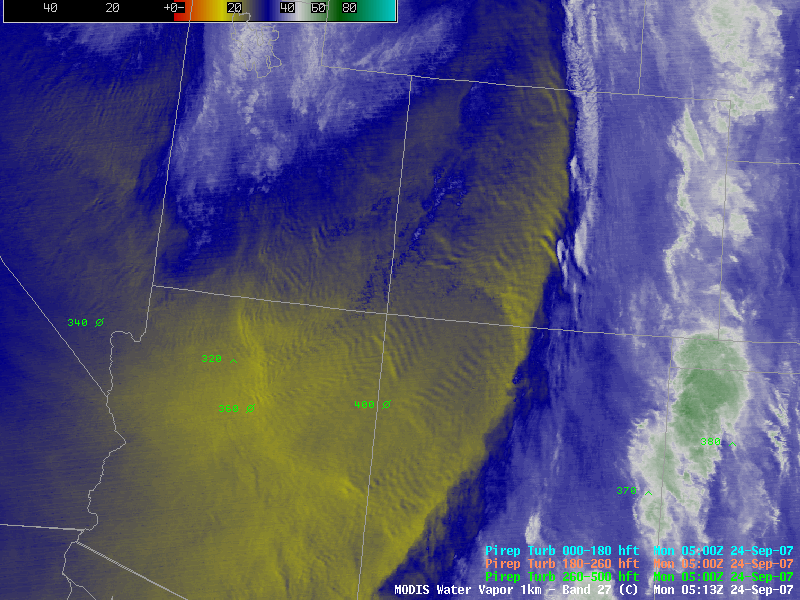
Satellite observations help pilots detect potential flight hazards such as turbulence. This image depicts turbulence created as strong winds blow over the Rocky Mountatins.
As the airplane’s wheels leave the runway, you can only hope that the pilot has all the information necessary to get you safely to your destination. With the help of a handful of CIMSS scientists, a team of researchers has developed several techniques to use meteorological satellites to aid pilots as they navigate potential perils in the skies.
Satellite observations can mitigate the threat posed by turbulence, in-flight icing, storms and volcanic ash, according to the cover article in this month’sBulletin of the American Meteorological Society. CIMSS’s Wayne Feltz,Kris Bedka, Sarah Bedka, Tony Wimmers and Michael Pavolonis(NOAA at CIMSS) contributed to the research covered in this paper.
As the single greatest cause of injury to passengers and flight attendants, turbulence is an obvious concern to airlines. However, this phenomenon is difficult to observe. Satellite measurements can help identify atmospheric features or conditions that could potentially cause turbulence. According to the research team, the detection techniques derived from these observations could contribute to an effective warning system when paired with other observations.
Storms can also affect the safety of those aboard aircraft. In fact, thunderstorms are the main reason for air traffic delays in the U.S. In the paper, the team discusses several strategies for working with the Federal Aviation Administration to improve satellite-based techniques to detect, track and monitor developing cumulus clouds.
In addition to developing operational aviation weather products, the research group uses satellite data to validate existing weather products. The CIMSS researchers involved are a part of the SSEC Satellite-based Nowcasting and Aviation Application Program (SNAAP).
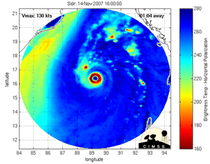
This animation shows Sidr as it approaches Bangladesh.
Animating satellite images—Cyclone Sidrgathered strength in the Bay of Bengal in the middle of November. Far from the storm itself, researchers at CIMSS monitored the cyclone using satellite observations. The Weather Channel featured a popular CIMSS product during many of the live updates on Sidr.
CIMSS’s Tony Wimmers and Chris Velden developed a technique to create a unique animation that depicts changes in a hurricane’s structure by combining images from different satellites. The Morphed Integrated Microwave Imagery at CIMSS (MIMIC) product blends a series of microwave images from polar- and other low-orbiting satellites to create animations of a storm’s structure similar in composition to more common radar loops.
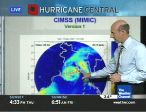
The Weather Channel’s Steve Lyons used a MIMIC animation of Sidr in a broadcast on November 15
Microwave imagery allows researchers to see inside a hurricane, leading to a better understanding of these powerful storms. This type of image provides unique information about a hurricane such as the formation of a secondary eyewall and details about eyewall replacement cycles, but inconsistent timing and slight variances in the images makes it challenging for a forecaster to visualize the recent history of a storm. MIMIC blends sequential but irregularly spaced images to create a smooth animation.
Rain, shine and laughter—On the last Monday of every month, CIMSS Director Steve Ackerman joins Professor Jon Martin to talk about everyone’s favorite topic: the weather. The Weather Guys explain current weather topics and answer listeners’ questions as a part of Larry Meiller’s call-in show on Wisconsin Public Radio. An article about the show made the cover of the November 14 edition of Wisconsin Week. The story highlighted the entertaining, but educational nature of the Weather Guys’ commentary.
Lift off!—NASA space shuttle forecasters relied on information from SSEC during the recent launch and landing of the Space Shuttle Discovery. Forecasters used the high-resolution MODIS sea surface temperature data to predict sky conditions as Discovery left the landing pad and again when the shuttle returned to Earth. The sea surface temperature product is a part of a data suite created at CIMSS for use in NASA and NOAA’s weather forecasting software package.
Predicting soil erosion—Knowing how much and where soil erosion occurs helps farmers improve field management practices to reduce erosion and optimize crop productivity. Christine Molling has worked with John Norman of the UW-Madison Department of Soil Science and collaborators at the Pontificia Universidad Catòlica de Chile to develop an agricultural model that simulates runoff that accounts for realistic topography. Many models of this type rely on the assumption that the field has uniform topography and soil characteristics—an assumption that generally doesn’t reflect reality. In a paper recently published in Soil Science of America Journal, the coauthors describe how the Precision Agricultural-Landscape Modeling System (PALMS) can predict changes over short distances by focusing on small sections of the field. Using a small grid allows the model to incorporate local soil properties and topography. The November issue ofCrops, Soils, Agronomy News featured an article about PALMS.
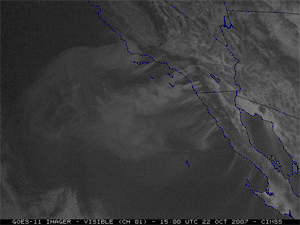
The plumes of smoke from the California wildfires are clearly visible in this animation of GOES-11 images.
Monitoring the California wildfires—In late October, wildfires tore across Southern California. The fires scorched approximately 500,00 acres and destroyed more than 1,600 homes. CIMSS researchers used satellites to track and learn about these fires. Satellites also offered some striking images of the smoke rising off of Southern California. Using the CIMSS Wildfire Automated Biomass Burning Algorithm(WFABBA), CIMSS researchers produced a four-day composite that allows the group to assess the overall development of the fires. Other satellite images showed the smoke plumes from the fires. NASA’s Earth Observatory web site featured an image of the smoke created using data from SSEC. For more information and images, please refer to the CIMSS Satellite Blog.
Hurricane trends—As the 2007 Atlantic hurricane season draws to a close, these powerful storms are still a hot topic. CIMSS tropical cyclones researcher Jim Kossin has contributed to many conversations about hurricanes and climate change. In September, the Wisconsin Engineerfeatured an article about Kossin’s research. Kossin led a team of scientists in an effort to create a more consistent hurricane data record. The team then conducted a reanalysis of the data and found a distinct increase in hurricane activity in the Atlantic. Kossin’s research also came up on CNN during a broadcast on October 20. Meteorologist Rob Marciano mentioned the recalibrated dataset: “A recent study conducted by respected scientist Jim Kossin re-analyzes the global data and shows that there has been no increase in hurricane strength worldwide in the last 20 years.”
Expanding forecasting tools—SSEC has added two new satellite data products to the suite of data provided to several National Weather Service forecast offices. The two new products will help forecasters predict high and low temperatures as well as the risk of fires and fog formation. SSEC directly contributes to more accurate weather forecasts by providing addition satellite data to NWS forecasters.
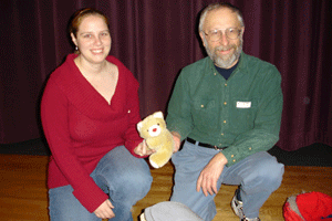
Shelley Knuth and George Weidner will bring Jelly Bear with them to Antarctica.
A teddy bear’s travels—The crew from SSEC’s Antarctic Meteorological Research Center (AMRC) will have a new traveling companion during this year’s trip to Antarctica. Jelly Bear, at stuffed bear from a second grade classroom in Pittsville, WI, will join Shelly Knuth and George Weidner on their way to the world’s southernmost continent. Antarctica is the only continent Jelly hasn’t visited during its 15 years of globetrotting. As a part of bear’s adventures, the students get to learn about all of the places their furry friend’s travels. Knuth and Weidner talked to the students about working in Antarctica and dressed up a second grader in the gear they wear to protect themselves from the continent’s harsh conditions. The Wisconsin Rapids Daily Tribune featured an article about Jelly Bear’s trip on November 10.