Monthly News Summary – August 2007
Visualizing hurricanes
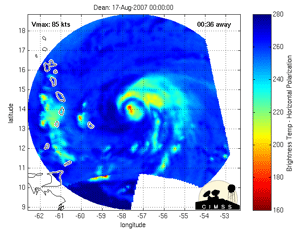
Tony Wimmers and Chris Velden developed a technique to blend images from different satellites into a smooth animation of a hurricane. Click the above image for an animation of Hurricane Dean.
Tracking changes in a hurricane’s structure leads to improved forecasts in hurricane intensity and analyses. Researchers from CIMSS have developed a technique to create a unique animation that depicts changes in a hurricane’s structure by combining images from different satellites.
The August edition of theBulletin of the American Meteorological Society features a paper by Tony Wimmers and Chris Velden about their Morphed Integrated Microwave Imagery at CIMSS(MIMIC) product. MIMIC blends a series of microwave images from polar- and other low-orbiting satellites to create animations of a storm’s structure similar in composition to more common radar loops.
Microwave imagery allows researchers to see inside a hurricane, leading to a better understanding of these powerful storms. This type of image provides unique information about a hurricane such as the formation of a secondary eyewall and details about eyewall replacement cycles, but inconsistent timing and slight variances in the images makes it challenging for a forecaster to visualize the recent history of a storm. MIMIC blends sequential but irregularly spaced images to create a smooth animation. According to Wimmers and Velden, MIMIC has the potential to significantly improve short-term forecasts of hurricane intensity.
The CIMSS Tropical Cyclones Research Team develops innovative techniques that use environmental satellites to monitor and study tropical cyclones. Several CIMSS products directly support forecasting at the National Hurricane Center.
Satellites observe rapid warming of Lake Michigan
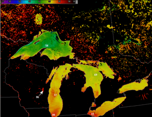
The NWS forecast office near Milwaukee featured this image on their web site on July 31. Created using data from MODIS, this image shows the temperatures of the waters of the Great Lakes.
As the Midwest endures the warmest months of the year, even the expansive Lake Michigan warms up at a rapid rate. Images provided by SSEC/CIMSS have allowed Wisconsin National Weather Service (NWS) forecast offices to observe the temperature change and to incorporate that data into more accurate forecasts.
With a shared goal of improved weather forecasting, SSEC/CIMSS provides several satellite-based weather observations to National Weather Service forecast offices throughout Wisconsin and around the country. Over the summer, Wisconsin forecast offices have relied on a SSEC/CIMSS product that uses data from polar-orbiting satellites to create regularly updated images depicting the temperatures on the surface of Lake Michigan. Theses images have appeared in the “Top News” section on the web sites for both the La Crosse and Milwaukee offices.
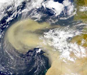
More dust blowing off of the Saharan Desert correlates with fewer hurricanes in the Atlantic.
A dusty year squelches hurricanes—With the most active months still to come, the Atlantic hurricane season has yet to show much force. Several factors influence the development of a hurricane and CIMSS’sAmato Evan has recently drawn attention to one that may soon play a more prominent role in hurricane forecasting. According to research done by Evan and colleagues at UW-Madison, more dust blowing off of Africa correlates with fewer hurricanes in the Atlantic. Evan says that a new study set for publication this fall provides further evidence for this connection.
Evan says that this summer has been a dusty one with about five times more dust than last year. Scientists at Colorado State University incorporated information about dust blowing off of Africa into their midseason forecast, using an index developed by Evan and Andy Heidinger. The forecast continues to call for an active season.
Scientific American, MSNBC and the Herald Tribune all featured Evan in articles about dust and Atlantic hurricanes. Ivanhoe Broadcasting also assembled a feature story about the correlation for TV stations around the country.
Seeing the Great Lakes from space—Jonathan Chipman and another UW-Madison professor led a reporter from WisconsinEye, a statewide public affairs station, on a tour of the University’s “Making Maps, Making History” exhibit, which is on display at the University’s Memorial Library. Chipman and his co-workers at SSEC’s Environmental Remote Sensing Center provided satellite images of the Great Lakes for the exhibit. During the tour, Chipman discussed satellite imagery of the state. He explained the differences in early satellite maps and how scientists use these images to understand changes in the landscape. As an example, Chipman showed successive maps of Lake Superior that clearly illustrated the expansion of Green Bay. Scientists can also use these maps to see how the city’s expansion affects water quality. In addition to providing information about water quality, Chipman described how scientists also use satellite images to track vegetation. Specifically, he talked about observing the spread of Reed Canary Grass, an invasive species in Wisconsin.
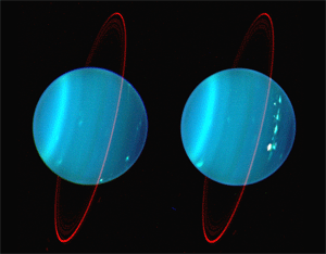
On August 19, scientists will have a rare view of Uranus. Larry Sromovsky and Pat Fry used the Keck telescope in Hawaii to create this image.
Views of Uranus—Larry Sromovsky and Pat Fry’s images of Uranus have appeared in many news outlets as well as books and scientific journals. Recently Sky and Telescope used the stunning images to accompany an articleabout a rare event occurring on August 19 that affords scientists a unique view of the planet. The Earth’s orbit will take our planet across the equatorial and ring plane of Uranus.
International satellite data workshop—In early June several CIMSS scientists traveled to Benevento, Italy where they held an international summer workshop on applications of satellite weather observations. Liam Gumley, Kathy Strabala, Paolo Antonelli, and Paul Menzel provided instruction through lectures and interactive lab exercises. Twenty-seven students attended from around the globe, including Hungary, Sudan, Cameroon and Ecuador. Titled “Applications with the Newest Multi-spectral Meteorological Satellites,” the workshop focused on currently available multi spectral and high resolution satellite data and a variety of meteorological applications. In addition to spreading tools for engendering environmental awareness, the workshop served as an opportunity to connect scientists from 15 different countries.
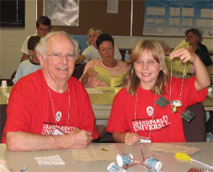
Participants in the Grandparents University Meteorology major made model weather satellites as a part of a two-day program of weather-related activities.
Grandparents and their grandkids major in meteorology—
Margaret Mooney andJen O’Leary tag-teamed as “Deans” for the Meteorology Major during Grandparents University, an opportunity for UW alums to return to campus with their grandchildren. On July 26 and 27, 26 UW Alums and their grandchildren visited SSEC to learn about the weather and SSEC’s rich history in satellite remote sensing. Jean Phillips, George Weidner and Jonathan Thom assisted in the adventure. Luke Schiferl, a student employee with CIMSS, also helped out by leading the students step by step through the assembly of a model weather satellite, which included adhering a SSEC logo to the antenna.
15 years of summer fun—SSEC/CIMSS hosted its 15th Summer Workshop on Atmospheric, Earth and Space Sciences from July 22-26. Seven high school students came to SSEC from as close as Madison, Wisconsin to as far away as Providence, Rhode Island. Scott Lindstrom,Margaret Mooney and Maria Vasys organized the workshop. Gary Wade (NOAA at SSEC), a program mainstay, played several integral roles throughout the week, including a session during which participants learned how to use SSEC’s unique weather data processing software called McIDAS. Jessica Staude and other SSEC employees assisted Wade with the McIDAS session.
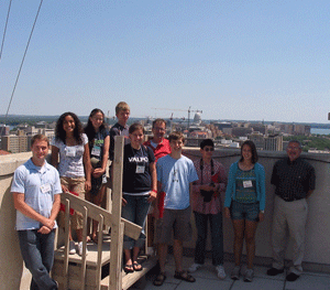
This year’s summer workshop for high school students was a success.
A tribute to the success of the program, several workshop graduates contributed to this year’s exciting program, including Chris Rozoff,Luke Shiferl, Jordan Gerth, Alex Harringtonand Victoria Vasys. While retaining many popular past activities and instructor, the program also welcomed a few new faces. This year’s newcomers included science historian Peter Susalla. With a narrative of personal experiences, Susalla taught basic astronomy concepts and constellations at the UW Planetarium. The students were delighted when Susalla pointed out the constellations after which several characters from theHarry Potter series are named. After a tour of UW’s historical Washburn Observatory, the group returned to SSEC where Larry Sromovsky gave an informative presentation on recent investigations of the outer planets utilizing the facilities at the Keck Observatory. Gerth and Harrington led meteorology sessions. George Weidner and Jonathan Thom gave a presentation about weather in Antarctica and AOS Chair Jon Martin led a discussion on climate change.
Dr. Norlene Emerson returned this year to lead the geology field trip to Devil’s Lake and Parfrey’s Glen. However, Lindstrom enhanced this walk through time with a new addition. Using VISITview, Lindstrom provided informative background before the trip.
New hurricane educational activity—Explore the atmosphere with SSEC/CIMSS educational online activities. Created by Tom Whittaker andSteve Ackerman, these interactive tools allow you to create a tornado, build a snowflake, understand the physics behind hitting a baseball, and much more. Whittaker recently added a few new features to the activity designed to help students understand the factors that contribute to hurricane intensity.
WeatherGuys—On the last Monday of every month, public radio listeners have the opportunity to pose questions to local weather experts Steve Ackerman, UW-Madison professor and the director of CIMSS, and Jon Martin, chair of the Department of Atmospheric and Oceanic Sciences. On July 30th, Ackerman fielded questions on his own. He began the show by discussing this summer’s drought in the Midwest. He pointed out that Lake Superior is nearing a record low water level. Ackerman also helped a photographer avoid haze with instructions to check for breezy conditions the day before a shoot and look for days with low relative humidity. Save up your questions about the weather and climate for the Weather Guys next show on August 27. Visit host Larry Meiller’s archive to find past episodes.
Recently published paper —A paper titled “Possible causes of decreasing cloud cover in the Arctic winter, 1982–2000” was published recently inGeophysical Research Letters. The authors are Chian-Yi Liu, Jeff Key (NOAA at CIMSS) and Xuanji Wang coauthored the paper with a colleague at Rutgers University. Previous work by the authors used satellite data to demonstrate the decrease in wintertime cloud amount over the central Arctic, in contrast to increasing cloud amount at other times of the year. This paper addresses the possible causes of the wintertime decrease, including moisture advection and changes in cyclonic activity.