Monthly News Summary – July 2007
Contributing to NOAA’s Climate Report
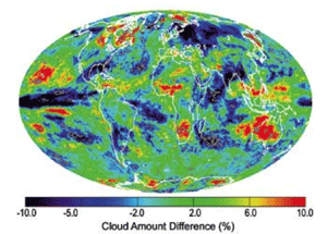
Andrew Heidinger, Amato Evan and Bryan Baum wrote a section on clouds for NOAA’s State of the Climate in 2006. This image is a map of boreal winter (January–March) absolute cloud amount differences (%) between the observations in 2006 and the climatological winter mean based on the period from 1982 to 2006.
Overall global temperatures in 2006 made it into the top ten warmest on record, according to NOAA’sState of the Climate in 2006. This annual report summarizes the year’s global and regional climatic conditions and includes sections written by SSEC scientists.
Andrew Heidinger(NOAA at SSEC),Amato Evan and Bryan Baum analyzed global cloud cover using a 25-year data set from an imaging instrument aboard NOAA polar-orbiting satellites. El Niño and La Niña had significant effects on cloudiness in 2006, accounting for much of the regional variability.
Evan also coauthored a section on the effects of aerosols on global and regional weather and climate. Comparing observations from 2006 to long-term patterns, Evan and two other researchers discussed varying aerosol amounts over African deserts, India, China, Indonesia, East Europe, boreal forests, the Arctic and the Amazon. In this section, Evan and his coauthors note that some regions have decreasing dust activity such as the Sahel and the Saharan deserts in Africa while other show increasing amounts of aerosols such as Indonesian and Eastern China.
The 2006 report is the first such report to include sections on clouds and aerosols.
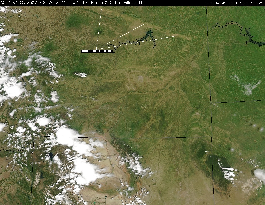
On June 16, large hail and severe winds left a mark visible from space. Click for a larger image.
When severe weather struck northeastern Montana, the local National Weather Service forecast office contacted CIMSS researchers for help with post-storm analysis. On June 16, a severe thunderstorm pummeled Glasgow, Montana and the surrounding area with heavy rains, large hail and severe winds. The path of the damage left by this storm was apparent in subsequent satellite imagery. To determine where the damage occurred, CIMSS researchers compared images taken on June 10 and June 20 by the MODerate resolution Imaging Spectroradiometer (MODIS) aboard NASA’s Aqua satellite. The forecast office in Glasgow requested an image centered over the damage swath. NASA’s Earth Observatory web site featured images of the damage processed by Liam Gumley.

In June 2007, SSEC and its cooperative institute published the inaugural issue ofThrough the Atmosphere. This biannual publication features the Center’s atmospheric and space science research and engineering projects and accomplishments. This research newsletter is available on the web and in print. Please take a moment to visit the newsletter web site. If you would like to be added to our mailing list for Through the Atmosphere, please contact Maria Vasys. If you would like to receive an email notifying you when new issues are available online, please email the editors.
The surface of the Sun—SSEC planetary scientist Sanjay Limayeexplained that the Sun technically has no surface for the Wisconsin State Journal’s “Curiosities” column on July 5. Limaye says that the Sun’s surface is a hot mass of gas that is essentially continuous with its atmosphere. The surface that we can see is called the photosphere and, according to the column, it resembles “water bubbling in a pot on the stove.” Every Thursday in the Curiosities column, a UW-Madison scientist answers a question posed by readers.
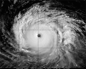
A recent study led by Jun Li and Elisabeth Weisz used data from Hurricane Isabel in 2003 as a case study to demonstrate that hyperspectral infrared satellite data can yield important information about hurricanes.
Delving into the eye of a hurricane—A study led by CIMSS scientistsJun Li and Elisabeth Weisz demonstrates that hyperspectral infrared satellite data alone can yield important information about hurricanes. Using this type of data, scientists can ascertain high vertical and spatial resolution moisture and temperature structures within hurricane eyes and their surrounding environment. An important feature of this data is that it is useful for both clear and cloudy skies. Hyperspectral infrared data also provides a clear depiction of the cloud-top structure of the hurricane. Using data from NASA’s Atmospheric Infrared Sounder gathered in 2003 for Hurricane Isabel, Li and Weisz showed that the difference between the temperature inside a hurricane eye and the outside environment can be as large as 20 K.
Hurricanes and climate change—A recently published book about hurricanes references research led by Jim Kossinthat provides scientific evidence that hurricanes have become stronger and more frequent in the Atlantic Ocean over the last two decades. The increasing trend, however, does not hold true for the world’s other oceans. Chris Mooney’s Storm World: Hurricanes, Politics, and the Battle Over Global Warming details the evolution of hurricane research and connections to climate change. RealClimate, a blog about climate science written by climate scientists,featured a review of Storm World and mentioned the reference to Kossin’s paper.
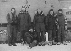
Professor Charlie Bentley (seated) led a research trip in Antarctica during the International Geophysical Year of 1957-58. He now leads SSEC’s Ice Coring and Drilling Services and recently supervised a trip to Summit Station in Greenland.
Polar reports—TheJune 28 issue of Field Notes, a polar newsletter, mentionedCharlie Bentley’s visit to Greenland’s Summit Station. Bentley is the Principal Investigator for SSEC’s Ice Coring and Drilling Services (ICDS). This was his first trip to Summit Station and he was there to oversee an ICDS drilling team. The article referred to Bentley’s “long and storied career on the southern-most continent.” While at Summit Station, Bentley gave a talk about the history of polar drilling sprinkled with personal anecdotes. “We all felt quite honored to be here with Charlie,” the article quoted Kathy Young, manager of Summit Station.
In The Desk—With an abundance of dust expected to blow over the Atlantic this summer, interest in the correlation of dust from African and hurricanes in the Atlantic continues to grow. Recently, The Desk, a journal for energy trading and market intelligence, interviewed Amato Evan about results from a study led by Evan that provides evidence for the correlation. Published in the July 6 edition of The Desk, the article focuses on Evan’s initial study and the impact of his research on energy traders whose work depends on the Atlantic hurricane season. Evan also mentions a follow up paper to be published within the next couple of months. This paper will qualify how much dust storms affect ocean temperatures in the Atlantic, a strong predictor of tropical cyclone activity.
On June 24, a wild fire spread across the Angora Wildland region of Lake Tahoe, CA. The smoke plume from this fire can clearly be seen in this MODIS image.
Seeing fires from space—SSEC/CIMSS researchers observed therecent wildfire near Lake Tahoe, CA using MODIS. On June 24, an illegal fire sparked a wildfire in the Angora Wildland region of Lake Tahoe. The devastating fire destroyed more than 250 homes and scorched more than 3,100 acres. Strong high-altitude winds pushed the smoke from the fire over Reno, NV. Processed at SSEC, MODIS imagery from June 24 clearly shows the stunning smoke plume.
Weighing in on QuikSCAT—An aging yet important weather satellite could fail at any time and plans to replace the satellite have been pushed to 2016. A reporter for Public Radio International recently interviewed CIMSS researcher Jim Kossin regarding QuikSCAT and what its loss would mean for hurricane forecasts.
QuikSCAT has provided significant weather information for almost eight years, well beyond its expected five-year life span. Kossin says that data from QuikSCAT improves the accuracy of certain hurricane forecast models. “When we go back and look at an entire season and look at the accumulated errors that we’ve had, you would see a difference [without QuikSCAT data],” Kossin explained in the interview.
At the center of many discussions of QuikSCAT is an unpublished study led by the late SSEC researcher Tom Zapotocny and Jim Jung (CIMSS at NOAA). According to Jung, the study will appear in October or November in Weather and Forecasting.
Seventeen middle and high school teachers participated in this year’s CIMSS summer workshop for educators.
Educating educators—This summer, the fifth annual CIMSS workshop for teachers expanded upon the traditional satellite meteorology program to include sessions on oceanography, geology and climate change. Seventeen middle and high school teachers from four states convened in Madison July 10th and 11th to learn more about remote sensing applications in the geosciences. Participants gained invaluable insight from presentations by Steve Ackerman, Margaret Mooney and Galen McKinley from UW-Madison as well as two visiting scientists, Ellen Lettvin from the University of Washington and Norlene Emerson from UW-Richland. Evaluations indicated that the educators deemed the day and a half as time well spent.
During the afternoon of the second day Sam Batzli from SSEC’sEnvironmental Remote Sensing Center taught a Geographic Information System (GIS) session to similarly positive reviews. The expanded workshop schedule and added GIS session reflect the commitment by CIMSS/SSEC to provide K-12 educators with the tools and knowledge they need to integrate satellite remote sensing data into their classrooms.
SSEC hosted the summer meeting of the Federation of Earth Science Information Partners in July.
SSEC hosts earth science meeting—Integrating Madison tourism tips and local culture with science, research and the Wisconsin Idea, CIMSS Director Steve Ackerman gave a memorable welcoming speech to attendees of the summer meeting of the Federation of Earth Science Information Partners (ESIP) hosted by SSEC on July 17th – 20th. Both Teresa Fryberger from NASA and Mary Kicza from NOAA/NESDIS made several references to his talk during the town hall meeting later that morning.
Other CIMSS/SSEC personnel involved in the event include Maria Vasys,Tommy Jasmin, Tom Whittaker and Margaret Mooney who was re-elected as the education committee vice-chair during the meeting. Vasys ensured that the meeting ran smoothly by coordinating logistics, demonstrating the best UW-Madison has to offer by securing the Pyle center for the conference and the Fluno center for the poster session. Tom Rinkfurther emphasized SSEC excellence with a session on an in-house software tool called HYDRA (Hyper-spectral Viewer for Development of Research Applications) during the technology workshops. Both during and after the event, ESIP members and directors extended their sincere appreciation to SSEC and UW-Madison for hosting the meeting.
Recently published papers— Geophysical Research Letters recently published a paper about a study analyzing the use NASA’s Atmospheric Infrared Sounder to gather information about clouds. Elisabeth Weisz, Jun Li, Jinlong Li, and Allen Huang coauthored the paper with researchers at Texas A&M University and NOAA’s Center for Satellite Applications and Research. The paper is titled “Cloudy sounding and cloud-top height retrieval from AIRS alone single field-of-view radiance measurements.”