Monthly News Summary – June 2007
Hurricane season begins in the Atlantic
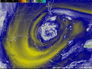
Subtropical Storm Andrea appeared in the Atlantic in early May. This is a water vapor image from GOES-12. As noted in the CIMSS Satellite Blog, Andrea ended the longest stretch (33 days) recorded in the satellite era without a tropical cyclone in any ocean basin.
The 2007 hurricane season officially began in the Atlantic Basin on June 1. From the effects of dust from Africa to the impact of climate change on these powerful storms,scientists at SSEC/CIMSS conduct hurricane research that contributes to more accurate analyses of these storms as they approach the coastlines and, consequently, more effective public warnings.
This season got an early start with Subtropical Storm Andrea arriving in early May. Many wondered whether this early storm had anything to do with climate change. “There’s enough standard deviation on either side of [the hurricane season dates] to not make a whole lot of difference,” explained Jim Kossin in a May 9 article for MSNBC’s LiveScience. Kossin recently worked with the National Climatic Data Center to recalibrate the satellite data record from the last few decades and found an increase in tropical cyclones in the Atlantic, mentioned in a May 29 article in the New York Times.
A research team including Amato Evan and Andy Heidinger published a paper last fall noting a correlation between dust blowing off of Africa and the intensity of tropical storms in the Atlantic. This study appeared in theChristian Science Monitor on May 17.
The CIMSS Tropical Cyclones Research Team develops innovative techniques that use environmental satellites to monitor and study tropical cyclones. Recently, Keith Blackwell of the University of South Alabama employed a CIMSS tool that uses satellite data to create radar-like animations of a storm’s structure, called the Morphed Integrated Microwave Imagery at CIMSS (MIMIC) product. Blackwell used MIMIC to look further into Hurricane Katrina and discover a damaging second eye wall. Microwave imagery allows researchers to see inside the storm, leading to a better understanding of these powerful storms.
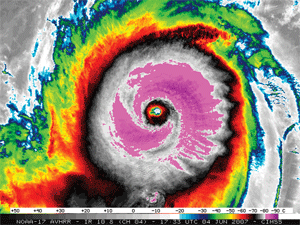
Super Cyclone Gonu became the most intense tropical storm on record in the Arabian Sea.
Other products developed by the CIMSS Tropical Cyclones research team contribute to forecasts at the National Hurricane Center (NHC). When Tropical Storm Barbara appeared at the end of May, the NHC discussion of the storm mentioned information from CIMSS as a contributing factor in the decision to upgrade the storm’s classification.
Imagery, animations, detailed forecast data and post-storm analyses make the group’s web site a popular stop for those seeking information about hurricanes. In early June, several media outlets, including CNN, used CIMSS imagery and animations of Super Cyclone Gonu, the most intense tropical storm on record in the Arabian Sea.
Severe weather tears through Wisconsin
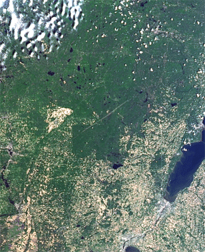
Clear skies on June 9 made it possible to see the destruction swath in imagery collected by the MODIS sensor on both the Terra (12:28pm) and Aqua (2:09pm) satellite overpasses. The tornado blew through northeastern Wisconsin on June 7.
As hurricane season began in the Atlantic, a different type of storm descended on the Midwest. A severe weather outbreak on June 7 caused rain, hail, strong winds and five tornadoes across Wisconsin.
Scott Bachmeierdocumented the outbreak in the CIMSS Satellite Blog. Bachmeier posted several impressive satellite images as well assome photos of hail taken by Derrick Herndon, a CIMSS employee who spent the evening chasing the storms in central Wisconsin.
Sam Batzli of SSEC’s Environmental Remote Sensing Center used satellite data to detect the damage caused by the tornado that touched down in northeastern Wisconsin. The image appeared in media outlets as well as NASA’s home page and its Earth Observatory.
SSEC/CIMSS provides many products to National Weather Service forecast offices. Recently, SSEC/CIMSS added a product with winds information from GOES imagers to the data stream at the Milwaukee/Sullivan office.
Support for operational forecasts—Since summer 2006, SSEC/CIMSS researchers have worked with operational forecasters at National Weather Service (NWS) offices around Wisconsin and the United States to integrate several types of satellite data into the Advanced Weather Interactive Processing System (AWIPS), which NWS uses to process and analyze weather data. A June 13 forecast discussion from the Milwaukee/Sullivan office referenced several SSEC/CIMSS products, including GOES sounder data and images from the Moderate Resolution Imaging Spectroradiometer (MODIS): “With clear skies across the Great Lakes, 15z MODIS image is a great data source.”
CIMSS also added another experimental product to the data stream provided to the Milwaukee/Sullivan office. Operational forecasters now have access to winds information derived from GOES imagers. This information will enhance mesoscale forecasting, particularly for approaching storms. Feedback from forecasters at the Milwaukee/Sullivan office will help CIMSS researchers improve the product for future operational use.
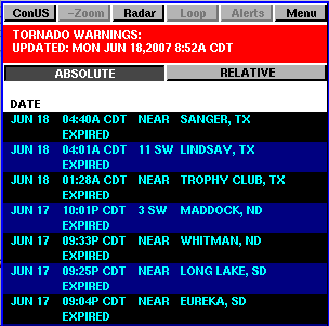
The PAW online service now includes information about tornado warnings in the United States.
Traveling with PAW—Whether you’re taking a weekend trip to northern Wisconsin or just driving home after a long day, PDA users can ease the commute with the aid of features via Russ Dengel’s PDA Animated Weather (PAW) online service. If you’re hoping to avoid congestion on roads in and around Madison, Dengel plans to add the Wisconsin Department of Transportation’s road web cams. With tornado season upon us, the PAW now provides a list of tornado warnings including the counties affected and the times at which the warnings expire. By sendingDengel an email address or a cell phone number, users can receive updates on tornado warnings within any county or counties in the U.S. If your travel plans take you out of the continental U.S., the PAW includes a new precipitation product that uses radar information over the U.S. and satellite-derived estimates over the rest of the area.
The next generation of weather satellites—A NOAA scientist stationed at CIMSS recently spoke about plans for the next generation of Geostationary Operational Environmental Satellites on WeatherBrains, a weekly webcast for weather lovers. Tim Schmit spoke with David Black about the instruments slated for spaceflight on the GOES-R series. In particular, Schmit highlighted what will be the first geostationary lightning detector and the improvements to the imaging instrument. “With today’s imagers, we have to choose if we want to look at the global scale, which would take a full disk every three hours, or the regional scale, or give that all up for smaller scale in a super rapid scan mode,” Schmit told Black. “With the [Advanced Baseline Imager], we don’t have to make those choices because it will scan fast enough that we can basically remove that conflict.”
Preparing for future satellites—From May 14-18, a few dozen SSEC/CIMSS employees traveled to Washington D.C. for the annual meeting of the GOES-R Algorithm Working Group (AWG). With the first of the GOES-R series scheduled for launch in 2014, SSEC/CIMSS scientists have an important role in preparation for the expected improvements in technology and observations that will lead to better weather forecasts. The AWG manages and coordinates the development of GOES-R products and validation. CIMSS scientists and NOAA partners stationed at UW-Madison co-chair the Aviation, Clouds, Cryosphere, and Sounding algorithm teams, and are members of the Aerosols, Land, Winds and Proxy data teams. The AWG Technical Advisory Committee also includes representatives from SSEC/CIMSS.
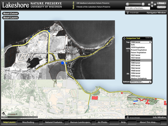
The Lakeshore Nature Preserve web site features aninteractive map that includes historical aerial images processed by ERSC’s Sam Batzli.
Lakeshore online—ERSC contributed images to UW-Madison’s Lakeshore Nature Preserve web site, which recently won a “Best Web Site” award from the Association of American Geographers’Places OnLine. ERSC’sSam Batzli processed the historical aerial imagery used in the Lakeshore web site’sinteractive map.
Predictions for the hurricane season—CIMSS products contributed toColorado State University’s prediction for the 2007 hurricane season. The prediction factored in the Atlantic Meridional Mode index, using data and references from Jim Kossin and UW-Madison’s Dan Vimont. The group also incorporated information about dust blowing off of Africa, an index developed by Amato Evan and Andy Heidinger.
Suomi Scholarship winner announced—Michael Phillips of Fond du Lac High School won the 2007 Verner E. Suomi Scholarship Award for Outstanding Achievement in the Physical Sciences. Phillips plans to attend UW-Madison in the fall and plans to major in Math. For the past seven years, outstanding high school seniors who are accomplished in the physical sciences have received a $1000 scholarship and a certificate of recognition at their high school graduation ceremony.
Recently published papers—Jun Li, Paul Menzel and Tim Schmit(NOAA at CIMSS) contributed to a paper titled “Comparison between current and future environmental satellite imagers on cloud classification using MODIS,” which was published in Remote Sensing of Environment andhighlighted on NASA’s Earth Observatory web site. Li, Menzel and Schmit also co-authored “Quantitative monitoring of a Saharan dust event with SEVIRI on Meteosat-8,” which appeared in the International Journal of Remote Sensing.