Monthly News Summary – February 2007
New instrument arrives
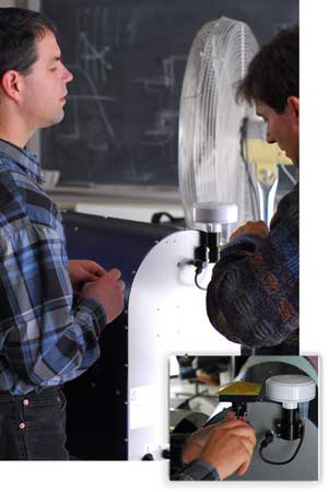
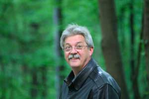
SSEC’s Dave Turner works on the new radiometer obtained through a Major Research Instrument grant from the National Science Foundation.
One of SSEC’s new instruments to gather information about the Earth’s atmosphere arrived in early February. This instrument, a microwave radiometer (MWR), is particularly useful for creating vertical temperature and water vapor profiles of the atmosphere.
SSEC procured this and two other instruments through a Major Research Instrument grant from the National Science Foundation. A lidar and a second radiometer will arrive in the next few months. The second MWR will gather data in three bands, rather than the standard two, making it more sensitive to the amount of liquid water in the atmosphere. SSEC’s enhanced instrument suite will allow researchers to gather many types of data and to validate instruments that take the same types of measurements.
Leftover gold from satellite project sells; proceeds to support research
SSEC sold the gold leftover from a space flight hardware project to fund remote sensing research.
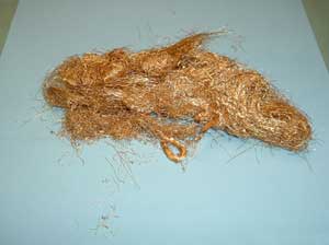
1,600 gold threads, each thinner than one uncooked spaghetti noodle, formed the insides of the beer can-sized component in a space-bound refrigerator. The University of Wisconsin-Madison center responsible for this unit recently sold the leftover gold to fund remote sensing research.
UW-Madison’s Space Science and Engineering Center (SSEC) sold the gold for $8,001 in a UW online auction that ended on February 5. Meant to fly into outer space, the gold will instead contribute to research that enhances the understanding of not only the Earth’s atmosphere but those of other planets as well.
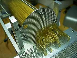
SSEC engineers devised a way to prevent the 1600 gold wires from touching.
Initially, SSEC purchased the spool of gold for an instrument slated for flight aboard a satellite built by NASA and the Japanese Space Agency. SSEC engineers were asked to build a subsystem of a refrigerator capable of cooling the satellite’s x-ray detectors to less than the temperature of space. The detectors needed to stay cold enough to sense the heat generated by one x-ray photon. One component of the subsystem consisted of 1,600 gold threads individually stretched to, without touching, form a 7-inch cylinder with a diameter close to that of a beer can.
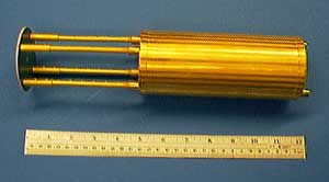
The salt pill was a part of a subsystem in a space-bound refrigerator.
In early January, the media covered the initial auction of the gold. TheWisconsin State Journal’s George Hesselberg reported the sale of “a shiny glob of tangled fishing line” in an article from January 7. Several Wisconsin news outlets ran the story. Regional news outlets picked up the story when the gold failed to sell in the initial auction. In addition to articles in Wisconsin newspapers, the Associated Press distributed the story. News of the gold auction appeared, in Minnesota’sPioneer Press, the Washington Post, CBS online, ABC online, and approximately 70 other media outlets.
From using satellites to spot icebergs to operating drills that dig deep into the ice, SSEC researchers and engineers continue to contribute in different ways to our understanding of the coldest, driest, and windiest continent on Earth—Antarctica.
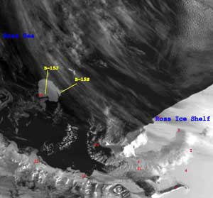
AMRC researchers spotted B-15S, Antarctica’s newest named iceberg. Click the image to view a larger image.
Every day, SSEC’sAntarctic Meteorological Research Center(AMRC) provides images of the icebergs in Antarctica. On February 1, George Weidner,Shelley Knuth, andLinda Keller (AOS) noticed that three pieces had broken off of one of the icebergs in the Ross Sea. At a little over 11 miles in length, this iceberg is big enough to receive a name.
The researchers reported their observation to the National Ice Center (NIC), which is in charge of naming icebergs. In a news release on February 2, NIC announced the new berg as B-15S and mentioned AMRC’s contributions. New icebergs form regularly through a natural process called calving. Bergs that are large enough receive names based on their points of origin.
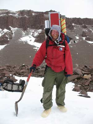
Jim Green traveled to Antarctica to provide drilling support for a climate change research project.
Also from SSEC, Jim Green, an engineer with SSEC’s Ice Coring and Drilling Services (ICDS), recently returned from Antarctica where he helped a team from Boston University and Brown University. ICDS provides drilling support for the National Science Foundation’s polar projects. This particular project needs ice core samples for research on climate change.
Green’s tales from this trip appeared in The Worthington Daily Globe, the newspaper in his hometown of Worthington, MN. The article mentions that Green lost 30 lbs on the “Antarctic Diet” of expired food and a daily workout of lugging 100 lbs of equipment around the icy tundra. Green also explained the drill, which he helped develop. “What I came up with drills slowly through rock and quickly through the ice,” he said.
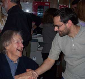
During his recent trip to Antarctica, Matthew Lazzara (standing) met several distinguished visitors including Sir Edmund Hillary (sitting).
AMRC’s Matthew Lazzara also recently spent time in Antarctica. While Green was drilling, Lazzara traveled around the continent installing and repairing UW-Madison’s Automatic Weather Stations(AWS). Lazzara also met up with a few distinguished visitors to the pole, including the Prime Minister Helen Clark of New Zealand and renowned explorer Sir Edmund Hillary.
Highlights from 2007 American Meteorological Society annual meeting
More than 2,000 meteorologists descended on San Antonio, TX for the 2007 annual meeting of the American Meteorological Society. Met with uncharacteristic yet familiar freezing temperatures, UW-Madison researchers, programmers and educators contributed to 45 talks and posters.
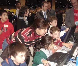
SSEC demonstrated online educational tools at WeatherFest. The three computers at the SSEC booth allowed visitors to try the online tools.
Before the meeting started, SSEC demonstrated online educational tools at the sixth annual WeatherFest, an interactive science and weather fair targeting local families, students and educators. Approximately 2775 visitors experienced a variety of related activities, including SSEC’s engaging display. During WeatherFest and at the general meeting, SSEC distributed 500 CDs with educational weather applets and 100 CDs with a satellite meteorology curriculum for grades 7-12.
During the general meeting, Margaret Mooney and Steve Ackerman gave several talks about SSEC outreach activities ranging from the successful high school summer workshop to an online set of techniques that help students grasp abstract geospatial and atmospheric concepts. The Weather Guys, Ackerman and Professor Jon Martin, also made an appearance. The Weather Guys answer questions every month on Larry Meiller’s talk showon Wisconsin Public Radio.
Other highlights from the AMS annual meeting include: Tom Achtor’s discussion of the next generation of the Man computer Interactive Data Access System (McIDAS), SSEC’s software package to process remote sensing data; Dave Turner’s talk about long-term climate observations using lidar instruments; and Ralph Peterson’s presentation on a nowcasting tool that improves the impact of satellite-derived sounder products in short-term forecasts.
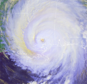
Chris Velden, co-chair of next year’s annual AMS meeting in New Orleans, says that hurricane research will be a significant topic.
Preview of the 2008 Annual Meeting—On invitation from AMS,Chris Velden, who leads CIMSS’s tropical cyclones research group, will co-chair next year’s annual meeting in New Orleans. Velden has plans to make 2008 a meeting to remember. “We are excited about the prospects of this being one of the best ever,” Velden says.
One major draw of the 2008 annual meeting will be a strong focus on hurricane research. Some potential related events include: tours of a Hurricane Hunter aircraft for the public and conference attendees, a special symposium on climate and hurricanes, and an AMS Presidential Forum on the lessons learned from Hurricane Katrina.
According to Velden, the meeting will also spotlight the societal benefits of strengthening ties between research and operations. Socioeconomic experts will provide attendees with an understanding of the impact their work has on society.
Juno web site—A new web site will provide information about the latest advances in Juno, NASA’s upcoming mission to Jupiter. SSEC’s Rosalyn Pertzborn leads the mission’s education and outreach component. Pertzborn worked with Hsuan-Yun Pi to develop this site.

Forecasters at the Milwaukee/Sullivan office have access to MODIS imagery in AWIPS.
Research improvesNWS forecasts —Researchers fromCIMSS recently visited the Milwaukee/Sullivan National Weather Service office to see how well certain experimental products applied in operational forecasting and to provide information about other potentially useful CIMSS products.
Currently, the forecasters at the Milwaukee/Sullivan office have access to imagery from Moderate Resolution Imaging Spectroradiometer (MODIS), an instrument aboard NASA’s polar-orbiting satellites, as well as some forecasting products from the CIMSS Regional Assimilation System(CRAS). CIMSS researchers integrated both the CRAS and the MODIS data into the Advanced Weather Interactive Processing System (AWIPS), which NWS uses to process and analyze weather data.
References to this data have appeared in many forecast discussions. On January 23, for example, a forecaster compared predictions from different numerical models to MODIS data and noticed that one model more accurately showed the cloud cover over Wisconsin. With this information, the forecaster was able to decide which prediction model would provide a more accurate 24-hour forecast.
This collaboration between university researchers and operational forecasters continued with a meeting in early January. After this discussion, the group from CIMSS will work with forecasters to integrate more products into AWIPS including sea surface temperature data over Lake Michigan; model forecast imagery and validation; and convective initiation over Wisconsin. CIMSS researchers will also begin to develop a tool to help the forecasters with short-term predictions of fog and low-ceiling clouds.
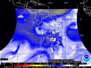
SSEC currently provides online access to GOES-10 data. GOES-10 now gathers routine data over South America.
GOES over South America —SSEC currently provides online access to data from NOAA’s GOES-10. Formerly GOES-West over the United States, GOES-10 now routinely gathers data over Central and South America.
The transfer of GOES-10 is a part of the Global Earth Observation System of Systems(GEOSS) project, which is a collaborative effort between NOAA and partners in the Americas and the Caribbean. GOES-10 is the first geostationary sounder to routinely gather data over South America in more than 20 years.
Additionally, the GOES-10 Imager conducts routine scans of the southern hemisphere. This is particularly useful when the current GOES-East imager conducts rapid scans over North America. During rapid scans, the imager gathers data over South America every three hours. GOES-10 provides continuous coverage every 15 minutes, meaning that South America is not left without satellite data.
SSEC helped with the GOES-10 check-in/check-out as the satellite moved from 135W to its current position at 60W. Tim Schmit (NOAA at SSEC) is a member of the GOES-10 technical team.
The decadal survey called for the completion of GIFTS, an instrument that will gather hyperspectral data about the atmosphere.
SSEC and the National Academy of Sciences’ Decadal Survey —SSEC has a significant role in a few of the projects promoted in the National Academy of Sciences’ decadal survey, released at the AMS annual meeting in early January. The report calls for a reinvestment by government agencies in environmental satellite missions in the next decade and beyond.
The report specifically called for the completion of the Geostationary Imaging Fourier Transform Spectrometer (GIFTS)—an instrument that SSEC has helped to develop. With innovative technological advances, GIFTS enables hyperspectral measurements that will lead to improved atmospheric analyses and weather prediction. SSEC designed and built the instrument’s on-board calibration system, and have devised ways to process and archive the unprecedented amount of data that GIFTS will provide.
SSEC also is involved in preparations for the National Polar-orbiting Operational Environmental Satellite System (NPOESS), which NASA and NOAA reorganized in the fall of 2006 after compounding delays and costs over budget. The decadal survey called for the incorporation of capabilities removed in the restructuring of the system. SSEC continues to make significant contributions to the NPOESS Preparatory Project, the bridge between current polar-orbiting satellites and NPOESS.
SSEC’s participation in the preparatory project includes science algorithm development; demonstrations of data acquisition, management and archiving systems capable of handling NPOESS data; and work on a software package to convert the raw measurements from NPOESS into useable data.
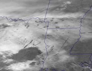
Scott Bachmeier explained these holes in the clouds in the CIMSS Satellite Blog.
Holes in the clouds —When satellite imagery and photos from the ground showed holes in the clouds, many turned to the CIMSS Satellite Blog for explanation. These “hole punch” clouds appeared over the southeastern United States on January 29.Scott Bachmeier, the research meteorologist who maintains the blog, explained that aircraft form this type of cloud when they fly through super-cooled clouds and cause the cloud droplets to freeze. The frozen droplets fall from the cloud leaving holes and streaks. USAToday’s weather blog referred to Bachmeier’s analysis in a related post. NASA’s Earth Observatory web site also cited the CIMSS Satellite Blog in an analysis of the satellite- and ground-based imagery of the hole punch clouds.
PAW to the rescue when winter arrives —Several thousand PDA and web users visit Russ Dengel’s PDA Animated Weather (PAW) online service every day. The PAW’s winter features are of particular use now that Wisconsin actual has winter weather. Last year, Dengel worked with the Department of Transportation to provide Wisconsin road conditions via PAW. In January, Dengel added information about flights in and out of the Dane County airport and national airport delays.
The American Meteorology Society named Paul Menzel an AMS fellow during the society’s annual meeting.
Paul Menzel named AMS fellow at Annual Meeting—The American Meteorological Society honored SSEC scientist Paul Menzel by naming him a fellow at the society’s annual meeting in January. This nomination recognizes Menzel’s outstanding contributions to atmospheric and related sciences throughout his career.
Menzel has been a part of the UW-Madison research community since 1967 and received his Masters and PhD in physics from the university. From 1999 through 2006, Menzel served as chief scientist for the Center for Satellite Applications and Research within NOAA’s Satellite and Information Services. He also directed SSEC’s Cooperative Institute for Meteorological Satellite Studies from 1997-1999. Menzel has made significant research contributions to satellite meteorology and has received international recognition. Menzel was also recently elected as the first Suomi Distinguished Professor.
The AMS is a scientific and professional organization that promotes the development and dissemination of information on atmospheric, oceanic, and hydrologic sciences.