Monthly News Summery – January 2007
Bringing together the study of the Earth and Sky
The Environmental Remote Sensing Center (ERSC) recently joined SSEC.
Integrating studies of the Earth with those of the atmosphere and beyond, the Environmental Remote Sensing Center(ERSC) recently joined the Space Science and Engineering Center (SSEC) in UW-Madison’s Graduate School.
SSEC and ERSC researchers anticipate unique research opportunities. A collaborative pilot study has already resulted in new techniques for displaying real-time weather data in geographic mapping applications. Working together across the disciplines creates new avenues for advancing understanding of our Earth and its systems.
Read the full news release here.
SSEC scientist appointed to Suomi Distinguished Professorship
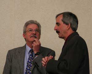
Paul Menzel (left) will begin his term as the first occupant of the Suomi Distinguished Professorship as this year’s spring semester begins.
This year, UW-Madison’s Department of Atmospheric and Oceanic Sciences will honor the educational and scientific contributions of Professor Verner Suomi, co-founder of SSEC, by creating the Suomi Distinguished Professorship. The first occupant of this position will be SSEC senior scientist Dr. Paul Menzel.
Menzel has been a part of the UW-Madison research community since 1967 and received his Masters and PhD in physics from the university. From 1999 through 2006, Menzel served as chief scientist for the Center for Satellite Applications and Research within NOAA’s Satellite and Information Services. He also directed SSEC’s Cooperative Institute for Meteorological Satellite Studies from 1997-1999. Menzel has made significant research contributions to satellite meteorology and has received international recognition.
“I look forward to exploring new environmental remote sensing capabilities with students and colleagues at UW,” says Menzel. “Hopefully I can adopt some of Suomi’s inquisitive approaches to achieve better understanding of Earth-atmosphere processes and trends.”
The Suomi Distinguished Professorship can be held for up to five years and focuses on candidates with research experience in remote sensing, weather, climate and the environment. Menzel’s term begins January 2007.
Celebrating 40 years of seeing the weather from geostationary orbit
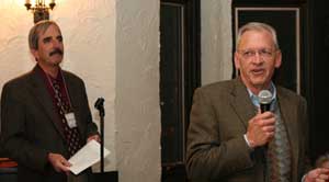
UW-Madison’s Chancellor John Wiley spoke at the reception hosted by SSEC on December 6.
Forty years ago observing the weather from a fixed orbit around the Earth was just a dream. SSEC cofounder Verner Suomi had a pivotal role in making that dream reality. Today, weather prediction centers rely heavily on satellite data to produce accurate forecasts. During December, SSEC celebrated the history as well as the future of this evolving technology.
Suomi invented the spin-scan cloud camera that flew in 1966 aboard NASA’s Applications Technology Satellite-I. This simple camera enabled the first pictures of Earth’s weather from a satellite in geostationary orbit and instigated profound changes in meteorology. Another of Suomi’s innovations made the manipulation of satellite imagery and data key elements of modern weather and climate studies.
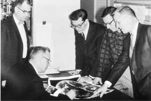
The launch of ATS-I into geosynchronous Earth orbit pioneered continuous viewing of weather from space. Suomi (seated) and Robert Parent (left) are shown here reviewing images taken by the spin-scan cloud camera.
The spin-scan camera pioneered continuous viewing of weather from space. The ability to obtain continuous satellite imagery of fixed points on the Earth allowed scientists to study changing meteorological conditions for the first time. Today, SSEC continues to push the field of satellite meteorology in new and exciting directions – many of which have roots in Suomi’s original concepts.
On December 26, UW-Madison published a news release about the spin-scan camera. “It was a milestone,” the release quotes SSEC Director Hank Revercomb. “It was up there before Apollo went to the moon, and it spawned a continual commitment to monitoring severe weather from space.” The news release also quotes SSEC scientists Sanjay Limaye and Larry Sromovsky—both of whom worked with Suomi. Limaye was one of Suomi’s students. Physorg.com and Technology News Daily published pieces of the release, and the Wisconsin State Journal mentioned the anniversary and the camera in an article on December 30.
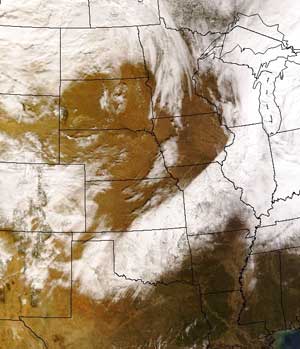
A MODIS image shows the snow across the Great Plains and the Midwest on December 1.
Snow and ice from space—While Madison has experienced a relatively snow-free winter so far, the effects of winter weather seen elsewhere serve as a reminder of winters past and the potential for the months to come.
In early December, an impressive winter stormrolled across the central United States. Although Madison only received two inches, nearly 17 inches of snow covered some areas of southern Wisconsin. An instrument aboard NASA’s polar-orbiting satellites captured the storm’s progression from freezing rain to snow. The Moderate-resolution Imaging Spectroradiometer (MODIS) imagery showed the icy covering on the ground during November 30 and the swath of snow across the area on December 1.
Snow was also visible from space on December 7. On the first day of the satellite’s science test, the new geostationary satellite, GOES-13, observed lake-effect snow near the Great Lakes. The storm, which developed over Lake Huron, dumped 18-35 inches in southeastern Ontario. Images from GOES-13 showed well-defined bands of lake-effect snows as they moved off of the Great Lakes. GOES-13 also showed streaks of snow cover after the storms had passed.
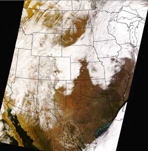
A MODIS true-color image depicts the widespread snow cover following the storm on December 21 and 22. Click on the image to use an online tool to see the difference between the clouds in the sky and the snow on the ground.
Another winter weather episode left travelers stranded at the Denver airport for several days. While the heavy snows missed Madison, the storm caused three days of rain and sleet. MODIS imagery shows the snow cover. Using an online tool to compare true color and false color images from MODIS, you can tell the difference between clouds in the sky and snow on the ground.
More information about the storms as seen from space and other satellite-based observations is available at the CIMSS Satellite Blog, which research meteorologist Scott Bachmeier maintains. According to Bachmeier, this winter set a new record of 31 consecutive days at or above 32º F during the winter season. The previous record of 29 days was set 1889-1890.
Bachmeier recently discussed weather trends during Wisconsin winters with a reporter from the Wisconsin State Journal. In the December 23 article, Bachmeier explained the patterns of winters over the past few decades and the influence of El Niño. “We’ve seen enough of these El Niño patterns to know they have a pretty significant impact on our area for people who like snow,” the article quotes Bachmeier.
Satellite data resource—SSEC’s webmaster Bill Bellon recently released a fresh look for one of the Center’s popular web resource in December. TheCIMSS GOES Realtime Derived Product Imagery page provides real-time access to SSEC/CIMSS products created using data from GOES satellites. The redesigned page is more user-friendly and meets current web standards.
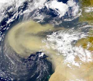
Originating over the Saharan Desert, the SAL, a mass of dry air laden with dust, causes temperature inversion and vertical wind shear.
Atlantic hurricanes and dust from the Sahara—In October, Geophysical Research Letters published a paper discussing the correlation between the intensity of dust storms in the Sahara Desert and the intensity of hurricanes in the Atlantic. Amato Evan,Andy Heidinger(NOAA at CIMSS), andChris Velden with Jon Foley, also of UW-Madison, and NOAA’s Jason Dunion analyzed 25 years of satellite data to understand this correlation. The study continues to receive media attention. New Orleans’ The Times-Picayune mentioned the correlation between Saharan dust and hurricanes in the Atlantic in an article about the 2006 hurricane season. Evan also explained the study and its implications in an article for Geotimes.
Space expertise—A recent article on WisBusiness.com mentioned SSEC’s collaboration with Esker Technologies to develop ZeroWire, a technology that will eliminate many problems with wireless devices. The president of Esker Technologies requested SSEC’s assistance in testing ZeroWire for space-based applications.
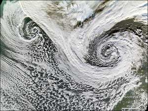
Jeff Key and Dave Santek provided an explanation of this image, which was taked with the MODerate Resolution Imaging Spectroradiometer. Click the image to go to the Earth Observatory.
Image interpretation—Jeff Key (NOAA at SSEC) and Dave Santekhelped editors of NASA’s Earth Observatory understand a satellite image of cyclones that formed off of the southern coast of Iceland. Key and Santek explained the nature of high-latitude cycones and their impact on global weather.
Source for satellite imagery—Satellite data processed at SSEC helps not only scientists but also the public to see the Earth and its weather from space.SSEC’s imagery reaches a large number via the SSEC web site, but several other sites feature SSEC imagery in various ways. One example is the Fourmi Lab—a science and computing web site maintained by a Swiss researcher.The Fourmi Lab web site has an Earth Viewer that allows users to select different features to view over a map of the Earth. SSEC provides data for the clouds, infrared clouds, global montage (called colour weather on the site), water vapor, and raw water vapor.
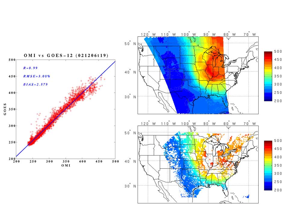
Lower Right: OMI ozone; Upper Right: GOES-12 Sounder ozone at 19 UTC, February 12 of 2006; and Left: the scatterplot between OMI ozone measurements and GOES-12 Sounder ozone retrievals.
Using GOES to monitor ozone—The January issue ofGeographical Research Letters included a paper by Jinlong Li and his colleagues (CIMSS and NOAA at SSEC) about the comparisons between Geostationary Operational Environmental Satellite (GOES) sounder single field-of-view total column ozone (TCO) product and the polar-orbiting Ozone Monitoring Instrument (OMI) measurements. The two observations agreed very well. OMI provides global ozone information once daily while the GOES sounder data ozone product is generated hourly over Continental United States. The GOES sounder ozone product can be used in regional air quality forecast models, studies of tropopause folding, and dynamic diagnostic research.
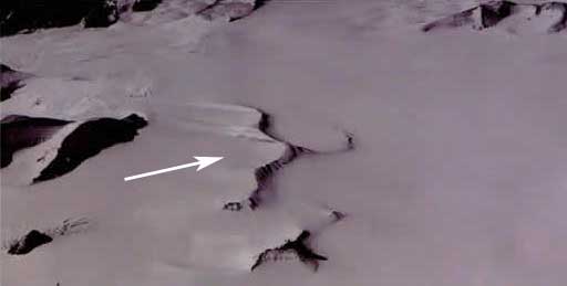
The cliffs to the right of the white arrow were named after Bruce Koci. The Koci Cliffs are in Antarctica.
Renowned engineer passed away—Bruce Koci, a renowned engineer with SSEC’s Ice Coring and Drilling Services (ICDS), passed away on November 13, 2006 after a long struggle with cancer. Koci designed the lightweight, solar-powered drill that allowed him to take the first core to bedrock from a high tropical ice cap. Koci also designed the Enhanced Hot Water Drill for IceCube, a project to construct the largest neutrino detector ever built. He was an integral part of the ICDS team. The Wisconsin State Journal printed Koci’s obituary on November 19.
Thanks to Jun Li, Paul Menzel and Scott Bachmeier for help with this issue.