Monthly News Summary – November 2006
Interactive tool facilitates international learning
From the Bahamas to Austria, South Africa to Russia, thousands of participants from more that 100 countries experienced the World Meteorological Organization’s latest satellite meteorology teaching techniques interface to interface with an interactive tool developed in part by the Space Science and Engineering Center.
The World Meteorological Organization (WMO) orchestrated this High Profile Training Event from October 16-27. Donald Hinsman from WMO called the event a “tremendous success” that “surpassed all expectations.” SSEC helped make the training event possible with an innovative software program that facilitates online professional training for weather forecasters.
SSEC’s VISITView helped make this training event possible.
Known as VISITView, the program accelerates the transfer of meteorological research into operational use by teaching forecasters how to use new data sources and processing techniques. VISITview connects students and instructors in real-time teaching and discussion sessions, enabling multiple users to view and respond to images and annotations simultaneously. The WMO training event used VISITview to visually connect participants in more than 100 countries.
Over the course of the event, the SSEC VISIT team had to handle minor crises to keep the crucial visual component running smoothly. For example,Tom Whittaker helped a session leader in Australian with a few technical problems a few hours before the session began. “MANY MANY (sic) thanks to Tom Whittaker who did a fantastic job of putting the lecture up for us with little notice and then fixing up a couple of other small technical problems,” Jeff Wilson of the Australian Meteorology Training Centre said.
SSEC’s Cooperative Institute for Meteorological Satellite Studies (CIMSS) collaborated with the National Weather Service and two other universities during the 1990s to develop and maintain VISITView. Scott Bachmeierand Scott Lindstrom are also part of the VISITView team.
SSEC recently provide support for a field experiment by providing daily global ozone reports, and five-day meteorological and chemical forecasts using the Real-time Air Quality Modeling System (RAQMS).
Data support in the field—SSEC researchers collaborated with scientists at theNASA Langley Research Center for an eight-month experiment to quantify the transport and evolution of pollution entering the United States from the Pacific Ocean and the Mexico City region as well as to validate satellite observations of tropospheric composition. SSEC personnel performed daily global ozone assimilation and five-day meteorological and chemical forecasts using the Real-time Air Quality Modeling System (RAQMS). RAQMS, a global to regional scale air quality model that predicts the evolution of meteorological variables (weather) and 55 chemical constituents, has been developed and maintained through a collaborative effort between researchers at the UW and NASA Langley.
During four different deployments of two to three weeks each, RAQMS was used in the field to provide forecasts of both weather and chemical composition. These observations helped determine the best times to deploy the various aircraft used in the field experiments. This field work is a part of the NASA Intercontinental Chemical Transport Experiment – North America (INTEX NA) Phase B, and the NOAA Texas Air Quality Study/Gulf of Mexico Atmospheric Composition and Climate Study field campaign.
SSEC researcher Todd Schaack was in Hawaii during April for a portion of the experiment that focused on the transpacific transport of pollution resulting from industry and biomass burning over East Asia. While in Hawaii, Schaak and another RAQMS team member provided daily forecast discussions and helped to plan three flights of NASA’s DC-8 aircraft. These flights intercepted and sampled pollution crossing the Pacific Ocean that originated from biomass burning over Southeast Asia and industrial sources over East Asia.
Research over the next year will focus on continued analysis of INTEX-NA data to build an understanding of the transport and transformation of chemical constituents and to advance predictive capabilities.
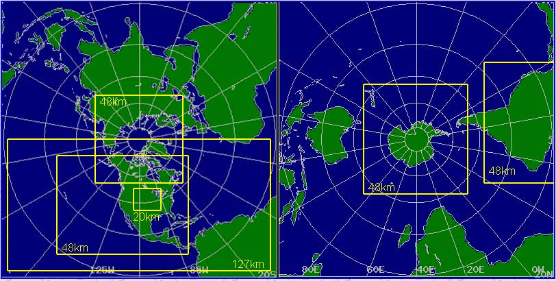
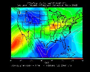
The improved CRAS web page allow users to select areas of interest by clicking on the map. Click the image to go to the real time CRAS web page.
Improving forecasts with satellite data —An experimental model developed by CIMSS researchers received a few upgrades. The improved model generates daily real-time forecasts for North America, Central America, portions of South America, and the Earth’s polar regions.
The CIMSS Regional Assimilation System, or CRAS, is an experimental forecast model that helps researchers to assess the impact of satellite data on a forecast. The updated, real-time forecasts provide more detailed information about the utility of satellite observations in numerical weather predictions.
The updated CRAS includes forecasts with better spatial resolution over North America, resulting in more detailed forecasts centered on a smaller area. The CRAS also now includes forecasts for South America and the Arctic. With the new real-time forecasts, users can click on an interactive map to go to areas of interest.
Metop-A launched —The European Space Agency (ESA) successfully launched Europe’s first polar-orbiting weather observatory on October 19. After ESA assessed the condition of the satellite, European organization for the exploitation of Meteorological Satellites (EUMETSAT) took control of the satellite and began in-orbit validation. CIMSS/SSEC scientists look forward to working with the data from this new satellite.
Meetings and Field Experiments
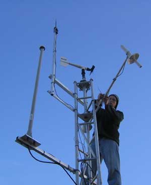
This image shows SSEC’s Erik Olson fixing instruments on the roof of SSEC’s mobile weather lab, which was in Louisville, KY for a field experiment.
AERIbago in the field—SSEC’s mobile weather lab, known as the AERIbago, traveled to Louisville, KY to help validate the accuracy of an improved sensor that flies aboard aircraft. The instrument suite in the ‘bago has contributed to validation efforts for various improvements to this sensor, which measures temperature and relative humidity during flight. These measurements contribute to increasingly accurate profiles of the atmosphere. Observations made during the aircraft’s ascent and descent are particularly useful, but challenging as several factors can affect the sensor’s performance.
Organizing observations —From October 16-18, representatives from several countries and agencies met to discuss a unified structure for observing snow and ice cover, permafrost and seasonally frozen land, glaciers, ice sheets, ice caps, and solid precipitation at the Third Integrated Global Observing Strategy (IGOS) Cryosphere Workshop. Jeff Key(NOAA at SSEC) is the leader of the IGOS Cryosphere theme and organized the workshop. The group will assemble a plan to coordinate global observations of the Cryosphere, which, among other benefits, will help researchers understand climate change. During the workshop, participants made significant strides toward the completion of the group’s report.
Climate change talk —On November 9, SSEC’s Ice Coring and Drilling Services hosted a public lecture on the basic concepts of climate change. Jim White explained evidence of climate change and the affects of human beings on this process. He also provided the audience with ways to help others understand climate change and the reasons why human beings need to take action. An audio file of the talk will soon be available online.
Papers
Volcanic Ash Detection —The November issue of the Journal of Atmospheric and Oceanic Technology featured a paper detailing a new method that uses satellite observations to automatically detect volcanic ash.Michael Pavolonis (NOAA at SSEC), Wayne Feltz, and Andy Heidinger worked with a researcher at NOAA’s Washington Volcanic Ash Advisory Center to develop this technique. The paper is titled “A daytime complement to the reverse absorption technique for improved automated detection of volcanic ash.” The technique works for measurements around the globe.
A recent review of BlackBerry-compatible online weather services onallblackberry.com included praise for Russ Dengel’s PDA Animated Weather (PAW) service. “If you are really into great weather maps, then PDA Animated Weather is the site for you,” the review reads. “Tons of fresh local maps, ability to zoom to local areas and all optimized for your BlackBerry.”
The PAW service provides free weather information formatted for personal electronic devices. Since Dengel created the service, users have found myriad uses for it from long-haul truck driving to fishing trips on Lake Michigan to monitoring the weather on patrol in a squad car. Dengel frequently adds products to the PAW to meet users’ needs.
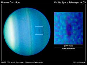
A team of researchers led by Larry Sromovsky saw a dark spot on Uranus using the Hubble Space Telescope.
More coverage of Uranus—A team of researchers led by SSEC’s Larry Sromovsky used NASA’s Hubble Space Telescope to capturetwo previously unseen events on Uranus: an eclipse by one of the planet’s moons and the appearance of a dark spot. The first of these events was the subject of a trivia question on Michael Feldman’s “Whad’ya know?” radio show. A contestant correctly answered the question and mocking of the planet’s name ensued.
News about Venus Express—SSEC planetary scientist Sanjay Limayecontributed to a BBC article on October 11 about Venus Express. Limaye posed questions relating to the Venusian atmosphere and the fact that the atmosphere spins faster than the planet. He also mentioned that Venus Express has provided good images of the unusual double vortex in the planet’s southern hemisphere. “Venus Express can help us define the depth and the structure of the vortex, and how the whole circulation is maintained,” the article quotes Limaye.
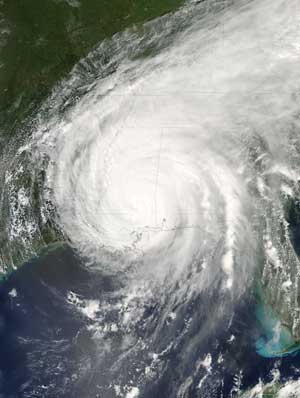
The destructive nature of hurricanes such as 2005’s Hurricane Katrina has brought media attention to research regarding hurricane intensity. SSEC’s Jim Kossin recently worked with colleagues to create a uniform data archive that helps researchers analyze trends in storm intensity. Amato Evan, Andy Heidinger and Chris Velden also recently published a paper discussing a correlation between dust storms in the Sahara Desert and hurricane intensity in the Atlantic Basin.
Global warming and Atlantic hurricanes—Sciencepublished an article titled “Global Warming may be Homing in on Atlantic Hurricanes” in the news section of the magazine on November 10. The article details Jim Kossin and colleagues’ efforts to create a “single, consistent record” of tropical cyclones. To make this record, Kossin and his group made changes to the data so that it would be uniform from 1983 through 2005. The uniformity ensures that trends reflect the data itself not variation in techniques for data acquisition and processing. While an analysis of the reprocessed data showed an increase in storm intensity in the Atlantic Basin, trends in the world’s other hurricane hot spots indicated a slight decrease in intensity and, in some areas, no trend was apparent. According to the article in Science, 85% of the world’s tropical cyclones occurred outside of the Atlantic Basin. Kossin concluded that global warming appears to have no effect on the intensity of tropical cyclones in the world’s other basins. Geophysical Research Letters plans to publish Kossin’s paper on this matter in an upcoming issue.
African dust and Atlantic hurricanes—Last month, Geophysical Research Letters published a paper discussing the correlation between the intensity of dust storms in the Sahara Desert and the intensity of hurricanes in the Atlantic. Amato Evan, Andy Heidinger (NOAA at CIMSS), andChris Velden worked with Jon Foley, also of UW-Madison, to analyze 25 years of data to understand this correlation. Triggered by a UW-Madison news release, media outlets around the globe published related articles. Evan recently appeared live on a news radio station in Delaware and on a program on Norwegian Radio called “Worth Knowing.” Velden discussed the paper in an article for The Columbus Dispatch, a newspaper in Columbus, OH. An interview with Evan also appeared on WeatherBrains (links to an mp3), “a podcast for people who love weather.”
Cold October —Madison experienced a particularly cold October this year. SSEC research meteorologist Scott Lindstrom noted that October brought three days during which the high didn’t reach 40 degrees (F). He also determined that the month’s average was 45.2 degrees —4.1 degrees below normal. Lindstrom said that this October was the ninth coldest on record.
At the Curriculum Design Summit, a pivotal planning session occurred to develop a new UW-Madison course that will help high school teachers teach Earth science.
High school teachers will soon have a new UW-Madison course to help cultivate an understanding of Earth science. Scheduled to debut next fall, several SSEC researchers, computer gurus and education experts have contributed to plans for this distance learning course tailored to the needs of high school science teachers.
A pivotal planning session occurred at the Curriculum Design Summit in Seattle November 10 and 11. One teacher from Madison and four from the state of Washington met with SSEC participants and other educators to plan the NSF-funded geoscience course, which will feature SSEC’s satellite meteorology training software known as VISITview.
Experts from the System-wide Change for All Learners program, an NSF comprehensive math and science partnership among a few universities and high schools, participated in the planning session including: the director of the Humboldt State University Indian Science and Engineering Program and project co-leader Ellen Lettvin from the University of Washington, a Seattle based evaluator, and Margaret Mooney, an education and public outreach coordinator from SSEC. All participants were wowed by the imagery thatRick Kohrs designed for the main web page. Scott Lindstrom further impressed the group by conducting a VISITview session from Madison, WI.Tom Whittaker’s applets and quiz images also delighted the planning team. The local co-leader of this project is Steve Ackerman.
Upcoming anniversary—On December 6, SSEC will celebrate the 40th anniversary of geostationary weather satellites. NASA launched the Applications Technology Satellite-I (ATS-I) at Cape Canaveral forty years ago. ATS-I carried the Spin-Scan Camera, one of SSEC founder Verner Suomi’s “gadgets.” The camera started a global revolution in satellite meteorology, the effects of which can be seen in modern and upcoming satellite technology. Please visit the 40th anniversary web page for more information.
Visitors from EUMETSAT—CIMSS hosted two visitors from European Organization for the Exploitation of Meteorological Satellites (EUMETSAT) as they met with scientists from the CIMSS satellite winds team to discuss current data and products derived at CIMSS. One visitor gave a presentation on current products at EUMETSAT and plans for the near future. The other discussed a new technique to assign altitudes to satellite-derived winds. Collaborations and future improvements on existing techniques were also discussed.