Monthly News Summary – February 2006
Field experiment in paradise
by Terri Gregory and Hank Revercomb
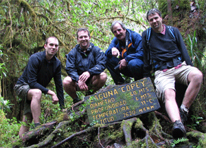
photo courtesy of the S-HIS team
|
|
While working for the Costa Rica Aura Validation Experiment, the Scanning HIS team found time to explore.
|
In January, when atmospheric conditions are just right in Costa Rica, NASA brought scientists from around the country together for the Costa Rica Aura Validation Experiment, or CRAVE. Throughout the month, they studied the sorts of measurements they hope to make with Aura, the third NASA satellite in the Earth Observing System. Aura is devoted to studying atmospheric chemistry. For example, one focus is to determine how ozone and other important trace gases are moved up from the upper troposphere to the lower stratosphere. This data will help us understand how Earth’s protective ozone layer changes and learn more about Earth’s changing climate. Costa Rica is in the InterTropical Convergence Zone, a band of continually regenerating thunderstorm cells around the equator. Where better to study the exchange of gases and water vapor than where air is regularly moved up and down through the atmosphere?
January 10-28 was devoted to remote sensing. SSEC’s Scanning-HIS team’s participation in this period was extremely successful and exciting. Flights were conducted with NASA’s high altitude WB-57 carrying a payload of about 20 experiments up into the tropical tropopause region. The air is very cold (180-190 K or around -90ºC) and very dry at these altitudes. Although the thrust of these two weeks was remote sensing, many of the instruments sampled in situ cloud, aerosol and gases, including isotopes. Spiral dives were used for altitude dependence and sonde comparisons. During some of the flights, exciting in situ validation experiments were also conducted at various locations around the country-side by our SSEC team (i.e., they went “site”-seeing).
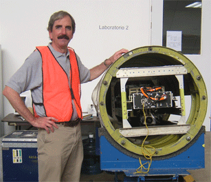 photo courtesy of the S-HIS team
|
|
The Scanning HIS performed well for all six science flights aboard NASA’s high altitude WB-57 and collected high quality data.
|
The S-HIS performed very well for all six science flights, plus a test and ferry flight, and collected high quality data for all but about two hours. The remote sensing package also included cloud radar, lidar and a far-infrared microwave radiometer (CoSSIR) that is a precursor to a cloud-ice experiment being proposed by CIMSS director Steve Ackerman. Significant analyses were performed in the field with preliminary findings reported at a science team meeting, but we look forward to more detailed analyses, including (1) validation of radiances from the Tropospheric Emission Spectrometer (TES, on Aura), (2) checks of TES upper tropospheric ozone retrievals, and related radiative transfer closure experiments, (3) studies of tropical cloud properties, and (4) retrieval of temperature, water vapor, ozone, and carbon monoxide. A follow-on to this experiment is planned for early 2007 from Guam.
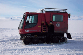 photo courtesy of Shelley Knuth
|
|
To reach the automatic weather station at Willie Field, Shelley Knuth drove a pisten bully, which travels at about 10 mph over the snow and ice.
|
Further Adventures—SSEC meteorologists Shelley Knuthand George Weidner returned from “The Ice” on February 1 after completing their assigned fieldwork (Knuth). Jessica Staude returned earlier after completing research and administrative duties. After several weather-related delays, Weidner was able to repair an acoustic depth gauge on an Automatic Weather Station at Willie Field. Knuth assisted Weidner. To get to the station, they trundled along in a Pisten Bully, a sort of truck that trudges slowly with a top speed of 10 mph but reliably over snow and ice. Perhaps Knuth’s most noteworthy adventure was driving a pisten bulley with a grad student and reporter to Windless Bight to dig pits in the snow and measure accumulation. She explained, “Windless Bight is as the name implies – not very windy. Therefore, it gets a lot of accumulation without a lot of blowing snow away from the area.” So the pits, dug to measure the weight of snow above the ice, were very deep. When they were able to reach hard ground, Knuth took core samples.
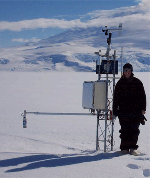
photo courtesy of Shelley Knuth
|
|
The Automatic Weather Station at Windless Bight was difficult to locate in the nearly featureless landscape.
|
In trying to find the Automatic Weather Station at Windless Bight, Knuth found a good rationale for children (or anyone) to study math: “Suppose you’re wandering around Antarctica in a pisten bulley looking for a tower with a GPS but no calculator … .” The station was hard to find, blending into the nearly featureless landscape, and the station coordinates were in decimal while the GPS was reporting in minutes. After reaching the station, our plucky trio dug the deepest pit yet: 57 “. Even after such an accomplishment, Knuth reports the highlight of the trip was finding a wrench sitting on the electronics box that was left the previous year. However, possibly the most memorable occurrence of Knuth’s entire stay in Antarctica was the skua attack. She fought off the water bird with bubblewrap! The reflections, Knuth said, scared it away.
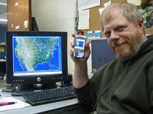
photo courtesy of Maciek Smuga-Otto
|
|
Russ Dengel’s PDA Animated Weather service, the PAW, continues to attract new users. Since a press release on January 6, information about the PAW has turned up on dozens of Web sites and two printed publications.
|
PawPrints—Russ Dengel’s PDA Animated Weather service, known as the PAW, has received a lot of attention over the last month. Since a university press release on January 6, information about the PAW appeared on dozens of Web sites and in two printed publications. (A complete list is available if required.) The wave of popularity leads new users to the PAW prompting compliments and suggestions for Dengel.
Funded partially through the Cooperative Institute for Meteorological Satellite Studies, the PAW provides users access to composite radar and satellite weather images and forecasts. Dengel also thinks that agencies like NOAA and NASA will want to display products on the site. Dengel notes, “Because we [SSEC are] recognized as a leader in personalized weather display presentations, we can offer agencies immediate exposure of their products to the general public as advance applied science. Sort of an ‘Electronic Soap Box’.”
Dengel creates his PDA-friendly products using data from SSEC’s Data Center. SSEC has also purchased the Web-enabled Treo 700w to demonstrate at the annual meeting of the American Meteorological Society, held in late January in Atlanta. The purchase of the Treo also will enable more inhouse testing of new features.
Pocket PC Thoughts is one Web venue that has promoted the PAW. Darius Wey, a contributing editor to this site, sent Dengel a glowing e-mail. “I just thought you’d be interested in knowing that I came across your PAW service today and was thoroughly impressed with its accuracy and level of detail,” Wey wrote. A user on old.Technocrat.net thought that the PAW is “a very good/handy system for those small devices. Will assist the accuracy of the most talked about subject…THE WEATHER.”
Steven Root from Bentley Systems also sent Dengel some words of praise and thanks. “This is fantastic,” Root wrote. “Thank you very much for your hard work in putting this together. Nicely done.” Jim Lattis, who directs the University of Wisconsin Space Place said that he could “see paw being very useful for planning astronomical observing sessions … .”
In addition to compliments, some users report difficulties or concerns. Dengel helps troubleshoot problems and accommodates as many requests as he can. For example, one user reported that the browser on his cell phone failed to load the PAW Web page. Dengel worked with this user to adjust the phone’s display settings properly. Another user found that the forecasts were “all smushed in a long thin column to the left of my screen and the text is so small you can’t read it.” Again, Dengel helped this user figure out how to fix this problem.
 |
|
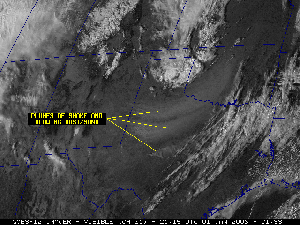
Satellite data helped distinguish smoke plumes from the dust and sand kicked up by strong winds. This image uses GOES-12 data. Click for a larger image.
|
Monitoring fires from space—Using a computer procedure, or algorithm, to process information from satellites, the Biomass Burning group within CIMSS monitored fires that swept across areas of New Mexico, Texas and Oklahoma destroying homes and scorching more than 600,000 acres. The Wildfire Automated Biomass Burning Algorithm (WF-ABBA) uses data from Geostationary Operational Environmental Satellites (GOES) to identify hot spots caused by fires. Data from the Moderate resolution Imaging Spectroradiometer (MODIS) helped distinguish smoke plumes from the dust and sand kicked up by strong winds in the Southern Plains region of the U.S.
At the AMS meeting —The exhibit hall of the 2006 annual meeting of the American Meteorological Society holds dozens of exhibitors from weather-related companies and organizations. SSEC exhibits there, calling their booth University of Wisconsin. Because SSEC is a satellite-meteorology leader, specifically through its Cooperative Institute for Meteorological Satellite Studies, and is known to many of the other exhibitors, it’s not unusual to find SSEC images displayed around the hall. This year, ITT, who makes satellites and their instruments for NASA, included a presentation on the Advanced Baseline Imager, an instrument for the next series of GOES. It included several SSEC images, with credit.
 |
|
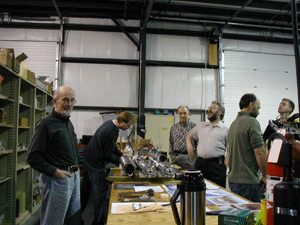
The Ice Coring and Drilling Services team designed, built and will operate the Deep Ice Sheet Coring drill. With the drill in its final stages of construction, the team invited the media to the warehouse to see the drill.
|
After months of carefully assembling the pieces of what looks like a giant erector set, UW-Madison’s Ice Coring and Drilling Services team is in the final stages of constructing the Deep Ice Sheet Coring drill (DISC), which will reach about two and a half miles into Antarctica. The National Science Foundation contracted ICDS to design, build, and operate the drill to retrieve deep ice core from Antarctica as part of the WAISCores research program. According to program manager Alex Shturmakov, “The WAIS Divide ice cores will provide Antarctic high-resolution records of environmental change for the last about 100,000 years. By analyzing the ice, scientists hope to be able to predict how human activities might affect the climate in the future.” A number of research teams within the U.S. and around the world will analyze the cores produced by this project.
 |
|
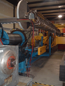
The winch maneuvers the drill in and out of the hole to pull the core to the surface. This spring, the drill will be disassembled and set to Greenland for field testing.
|
After onsite testing in its eastside Madison warehouse, the drill will be taken apart and transported with all associated equipment and personnel to Greenland for a field test over the spring and summer. It will then head to the West Antarctic Ice Sheet, where ICDS will assemble it and begin collecting ice core for research purposes.
With the DISC drill together for testing, ICDS invited Madison media representatives to come see it. Madison’s ABC-TV affiliate, WKOW (Channel 27) featured the drill and its expected scientific contributions on Wednesday, February 1 on their 6 p.m. and 10 p.m. news programs. The Wisconsin State Journal placed stunning pictures of Bill Mason, chief mechanical engineer, and some crew members with the drill on the front page of the local section on February 2. Reporter Karen Rivedahl’s brief article was cut to fit on an inside page. WIBA Radio featured an interview with Shturmakov on February 2. Wisconsin Public Radio’s Gil Halstead interviewed both Bill Mason (chief mechanical engineer) and Kendrick Taylor (chief scientist, University of Nevada’s Desert Research Institute for news pieces throughout the state (WERN and WHA in Madison) February 2 (afternoon) and February 3 (morning), available on the Web in Current WPR News Stories and later inNews Archives by month. Halsted noted the DISC drill’s importance in global change research.
In addition to the DISC drill, ICDS maintains and operates a full suite of drills for different research purposes: shot hole drills, coring drills, and hot water drills.
SSEC senior scientist, astrophysicist Wilton Sanders notes the usefulness of the Chandra telescope in a NASA news release (January 10). Sanders is Chandra project scientist, and noted that new information about black holes shows “how valuable it is to observe the universe at different wavelengths besides just the traditional optical wavelengths.” Sanders was commenting on a separate analysis of 56 elliptical galaxies that, he said, showed that “these apparently static galaxies in reality are still evolving due to the interaction with their central black holes.” The Chandra X-ray Observatory gathers information about X-ray sources that are billions of light years away.
While working at NASA headquarters, Sanders serves as NASA program scientist for a group of X-ray missions in which NASA plays a role: Chandra, NuSTAR, XMM, Suzaku, and Con-X. Sanders also oversees NASA’s High Energy REsearch and Analysis program and now leads NASA’s Research and Analysis group. Sanders is principal investigator for SSEC’s Diffuse X-ray Spectrometer experiment that flew on Space Shuttle Endeavour in 1993 and took X-ray measurements of the interstellar medium. Anne Kinney, Director of NASA’s Universe Division, said in a recent letter apprising SSEC of Sanders’ NASA contributions, “We are very grateful to have Dr. Sanders here, and grateful for the improvement that he has brought to the research program.” She credits Sanders with bringing better order to NASA’s grants program, enabled better management of NASA’s research and science resources.
Warm month—January 2005 is one of the warmest in recent history, and SSEC’s Scott Bachmeier was called upon to explain why. The Milwaukee Journal Sentinel’s Tom Held interviewed Bachmeier who admitted that this winter’s 42 straight days with a high temperature above 30 (Milwaukee) “is a warmth of historic proportions.” January’s warmth in Milwaukee has exceeded the norm by 13.3 degrees thanks to a jet stream that has kept cold air out of the U.S. Bachmeier also spoke with Channel3000.com, WISC-TV’s website and noted that computer models expect the jet stream to dip back down to normal in the next few weeks. Don’t put away your woolens just yet. However, January continues a trend that was seen throughout 2005. NASA’s Goddard Institute for Space Studies presents some convincing data.
Published papers—Geophysical Research Letters published a paper on hyperspectral cloud properties co-authored by several SSEC, including CIMSS, researchers. Xuebao Wu (CIMSS), Jun Li (CIMSS), Allen Huang(CIMSS), Kevin Baggett (CIMSS), Hank Revercomb (SSEC), and Paul Menzel (NESDIS/STAR at SSEC) all contributed to “Evaluation of AIRS Cloud Properties using MPACE Data.”
Sanjay Limaye, planetary scientist at SSEC, submitted the paper, “Multi-Observatory Observations of Night-side of Venus at 2.3 micron – Atmospheric Circulation from Tracking of Cloud Features,” to the Bulletin of the Astronomical Society of India in November 2005. Co-authors are Johan Warell (Department of Astronomy and Space Physics, Uppsala University, Uppsala, Sweden), Patrick Fry (SSEC) and Eliot Young (Southwest Research Institute, Boulder, Colorado). The paper describes observations of Venus made in May and July 2004 with the 1.2-meter Mt. Abu Telescope at Gurushikhar, the Himalayan Chandra Telescope at Mt. Saraswati, the Hanle and Nordic Optical Telescope at La Palma, Canary Islands and the NASA/Infra Red telescope Facility (IRTF) at Mauna Kea, Hawaii. The observers found that, by combining multi-site observations, they were able to make measurements of zonal cloud velocities over baselines that are several hours long for a better idea of the evolution of features over time.
Andy Heidinger (NOAA at CIMSS) and Mike Pavolonis (CIMSS) published a paper on the climatology of multilayer cloud in the Journal of Climate. Titled “Global Daytime Distribution of Overlapping Cirrus Cloud from NOAA’s Advanced Very High Resolution Radiometer,” this paper described a new climatology of multilayer cloud from the Advanced Very High Resolution Radiometer (AVHRR) and is the first publication of results from the AVHRR Pathfinder Atmospheres Extended (PATMOS-x) project.
Two Views—Ron Seely features a collaboration of Native American historian Patty Loew and planetary scientist Sanjay Limaye in the Wisconsin State Journal (February 2). With help from Rosalyn Pertzborn, who directs SSEC’s Office of Space Science Education, Loew and Limaye received a University of Wisconsin-Madison Baldwin Endowment grant to help students on Wisconsin’s tribal reservations understand that, not only are their stories about the stars culturally important, but “their ancestors also had a sophisticated and accurate understanding of the stars and the planets.” The project, called “One Sky, Two Views: Expanding Our Cultural Universe,” will at first consist of school sessions, a conference, and a book. In a separate letter, thanking the paper for featuring the project, the co-investigators said that they hope to expand the program with support from federal agencies such as NASA, “whose space flight programs are committed to increasing the numbers of young people from rural and underrepresented communities in the science and engineering professions.”
Outreach for AMS—Over 1000 people visited the SSEC booth at WeatherFest on Sunday, January 29. The American Meteorology Society held its annual professional meeting in Atlanta from January 29 to February 2, leading with this popular public outreach event. Event coordinators counted 2580 folks walking through the main turnstiles. For most of the four-hour event three lines of mainly middle and elementary school-aged children with their parents waited two and three people deep waiting to try out the educational Java applets that Tom Whittaker (SSEC software developer) and Steve Ackerman (CIMSS director) have developed over the years. According to outreach specialist Margaret Mooney, “It was a huge success as an outreach effort.”
Satellite science education online —The first twelve Reusable Content Objects (RCOs) have been released and are being used to create the very firstSatellite Observations in Science Education (SOSE) online learning activity: Hunting Icebergs. The SSEC hosted SOSE website was created to describe the project, the learning activities in development, and provide a directory of available RCOs with a user’s guide. The SOSE project was also accepted and cataloged in NASA’s Global Change Master Directory this year.
Special thanks to Sally Loy and Dave Tobin for their assistance with this edition.