Monthly News Summary – January 2006
Such is life in Antarctica
by Jen O’Leary
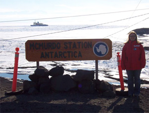 photo courtesy of Shelley Knuth
|
|
The Automatic Weather Station project maintains instruments in remote areas to gather valuable meteorological data. Shelley Knuth and George Weidner headed to Antarctica to perform maintenance on these instruments.
|
The day after Christmas, Shelley Knuth (AWS and AMRC) began an arduous journey to the end of the earth. For more than a month, Knuth will traverse Antarctica’s icy landscape to check up on instruments across the continent that gather important meteorological information.
“While these stations are very robust and can withstand extremely cold temperatures and high winds, sometimes they can break and require someone to visit them,” Knuth says. The Automatic Weather Station project within SSEC currently maintains over 60 sites. During this visit, Knuth will visit several sites and hopes to install two new stations.
Automatic weather stations provide an invaluable resource for researchers and forecasters, as well as the general public, by collecting meteorological observations in Antarctica with no human input at each site. Each station measures temperature, pressure, wind speed, wind direction, and relative humidity. With co-worker George Weidner (AOS), Knuth will perform maintenance and ensure continued data retrieval. Jessica Staude, an AOS student with Steve Ackerman, is the lead worker for AMRC on this trip to Antarctica. She will help move the AMRC in Crary Lab to the forecast office.
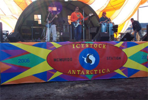 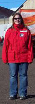 photo courtesy of Shelley Knuth
|
|
McMurdo station serves as home base for Knuth, Weidner and Staude. Early on in their visit, they experience Icestock, a day-long music event.
|
McMurdo Station serves as home base for Knuth, Weidner and Staude. Before getting to work, the researchers must attend classes required for all visitors to Antarctica. Snow School provides information about survival out in the cold. Instructors teach visitors useful skills such as how to pitch a tent, how to prevent and treat cold weather maladies, and how to operate communication radios.
“The parka is bright red or a few reasons – one, in case you get lost and Search and Rescue are trying to find you, they can more easily spot you. Second, a seal will be less likely to mistake you for a penguin and see you as dinner,” Knuth says.Beyond survival tactics, Knuth, Weidner and Staude also received Extreme Cold Weather gear. This ensemble includes: snow pants, two layers of thermal underwear, wool socks, a hat, gloves, boots, and a giant red parka. Altogether, the gear weighs about 30 pounds.
In addition to learning about safety and survival in the continent’s rather inhospitable climate, visitors also hear about the more mundane aspects of life in the southernmost part of the world.
For example, Knuth described a meeting that focused on garbage. Most of the trash produced by human beings in Antarctica ends up in the United States for recycling. This class instructs visitors on proper waste disposal. “About 60% of it is recycled. Less than half of that is done in major U.S. cities,” Knuth reports.“You can’t say I wasn’t paying attention this morning.”
After attending the required classes, Knuth and Weidner began to visit the automatic weather stations. They started with a trip to the Linda AWS site. “George [Weidner] is going as the expert, and I am going as the person who hands him stuff,” Knuth says. Finding the site proved a challenging task.
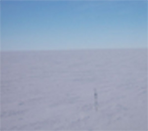 photo courtesy of Shelley Knuth photo courtesy of Shelley Knuth |
|
In order to perform maintenance on the stations, researchers must first locate them. A station can migrate because the ice flows off the Transantarctic Mountains.
|
Using global positioning technology, the researchers determine the last known position of the station. A station can migrate because the ice flows off the Transantarctic Mountains. Aboard a helicopter, Knuth and Weidner flew to the site’s most recent coordinates. Once they arrived near the site, they needed to find the station using their eyes.
“We are trying to see something that’s 3 meters tall in an expanse of white,” Knuth says. “One would think that it would be easy to spot, since it’s the only thing out there. However, it is not.”
Having found the station, Weidner and Knuth disembarked and began to work. The Linda station stopped transmitting data back in June. The pair found no physical damage, and was able get the station up and running by simply rebooting the system.
Since the trip to the Linda station, Weidner and Knuth have visited several more sites. Knuth now plans to fly to West Antarctica. Due to various delays, she had not left as of January 9. “This is a good example of how unpredictable things are on this continent!” Knuth says.
Stayed tuned for Part 2 as reports come in from the team in Antarctica.
Animated weather for PDAs—Russ Dengel’s (SSEC) PDA Animated Weather service, known as PAW, continues to benefit a diverse community, from long-haul truck drivers to firefighters in Puerto Rico to commuters trying to get to work safely on a snowy morning, according to a January 6 news release by Jennifer O’Leary (SSEC). The free service allows PDA users to access real-time radar and satellite weather images and forecasts whenever and wherever.
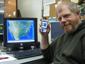 photo courtesy of Maciek Smuga-Otto photo courtesy of Maciek Smuga-Otto |
|
Dengel’s PAW allows PDA users to access real-time radar and satellite weather images and forecasts whenever and wherever.
|
Based on the release, the January 9 edition of the Wisconsin State Journal reported on the tool’s growing popularity. Reporter Gena Kittner interviewed police officer Dave Zittlow of Fond du Lac who uses the PDA-focused animations and imagery to avoid thunderstorms. Skip Voros, Executive Director of theMilwaukee Area Skywarn Association said that the “storm spotter (SKYWARN) community will find this program a valuable tool for tracking severe storms.” They now link to the PAW website.
As reported last month in SSEC’s In the News, Dengel continues to add tailored imagery for interested users throughout the world, although aimed mostly at the United States. He is able to accommodate international requests because SSEC receives satellite data from around the world in near real time. The SSEC Data Center archives much of the satellite data it receives and provides it to scientists and others whose research and development helps fund Data Center operations. Imagery is provided to the public for free on the Web.
Dengel uses software developed at SSEC to produce his animations. Since 1972, McIDAS (the Man computer Interactive Data Access System) has been used around the world by weather organizations. Weather Central in Madison, Wisconsin, that provides weather forecasts for the channel 27 viewing area, still uses it. This flexible and powerful visualization and analysis tool is at the heart of not only Dengel’s PAW, but other focused meteorological tools.
AniS in Iraq—U.S. Air Force Staff Sergeant Carl P. Densford reports, “I am extremely pleased with the results I got from using your coding and web page. We are going to be using it for radar viewing over the internet.” SSgt. Densford noted that the program they were given for viewing radar “wasn’t very user friendly. … We couldn’t really tell what was going on with movement of features, let alone transfer the images anywhere.” With his supervisor, Densford wrote an automated screen-capture program that renames and saves consecutive radar images to a folder. He uses AniS, developed by SSEC programmer Tom Whittaker (SSEC), to make them useful. “It allows us to see these loops and manipulate the[m] … . The loop script we were using was just a simple start, stop, next and previous. … With your software and page, our capabilities have increased exponentially. Our radar will be the only one in Iraq viewable via the internet, letting the entire area of operations and all military installations across the globe see our products. … Just wanted to let you know the value of what you all have produced. Thank you.”
Image for Franklin exhibit—The Benjamin Franklin Tercentenary committee will use an SSEC image in a traveling exhibit about Ben Franklin. The MODIS image, from SSEC’s Direct Broadcast facility, will appear in a computer interactive exhibit that illustrates the Gulf Stream.
Updated software —The latest print issue of NASA’s The Earth Observerannounced SSEC’s updated International MODIS/AIRS Processing Package (IMAPP). The software package makes it possible to process raw data from MODIS and AIRS instruments aboard NASA’s Terra and Aqua satellites. The announcement lists some changes including improvements to the useful cloud mask algorithm and enhancements to profile and cloud-top property algorithms. Access IMAPP through the web site.
Arctic explorers aided—Bob Rabin (SSEC) provided data to Lonnie Dupre and Eric Larsen for a summer 2005 crossing of the Arctic, starting in May. When talking to an Xexplorersweb interviewer, the explorers said an SSEC scientist “helped construct some rough satellite images of ice conditions during the summer.” Rabin spends half his working time in Madison, WI and the other in Norman, OK at the National Severe Storms Laboratory. Despite support like Rabin’s and others’, weather and ice forced the duo to cut short their trek in June.
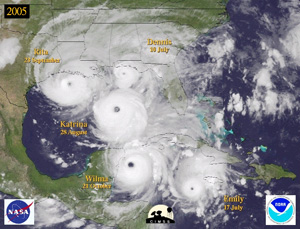 Fanmail—Aaron De Runtz, Technical Operations Manager of BevMo!(Beverages & more!), had this to say about our Data and Imagery site: “Love your web site. Weather nerd paradise. Keep up the good work.” We love the compliment.Adding valuable images and data—Anarticle in Aviation Week & Space Technologyfrom December 11 emphasized the benefit of adding MODIS polar wind data to mid-range forecast models. Along with the boost provided by polar winds, the article detailed several other recent forecasting improvements that mitigated the damage caused by the 2005 Atlantic hurricane season. The hurricane montage created by CIMSS’s Tropical Cyclones group accompanied the article.
Meetings and Field Experiments
AOS and CIMSS—Making Waves, semiannual publication of UW-Madison’s Department of Atmospheric and Oceanic Sciences, featured the 25th anniversary of the Cooperative Institute for Meteorological Satellite Studies in its Fall 2005 issue. The article noted that “over 100 AOS graduate students have conducted research in partnership with CIMSS scientists.
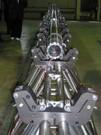 photo courtesy of Jenny Stepp photo courtesy of Jenny Stepp |
|
The DISC drill will be deployed to the West Antarctic Ice Sheet in fall of 2006 where it will retrieve deep ice cores to construct a climatological history.
|
Deep cores —NASA’s Earth Observatory web site features a profile of scientist Richard Alley who works in Greenland drilling cores into the ice sheet for clues to ancient climatology. Related pictures show drillers from SSEC’s Ice Coring and Drilling Services using their 4-Inch Drill in Greenland this past summer. Don Lebar, ICDS project manager notes that, while working on a project for Eric Steig of the University of Washington, “we did some testing of different cutters, etc., with the drill as well.” The drillers were also performance testing two Eclipse Drills. With special engineering expertise, the ICDS continually adds to its fleet of drills, to be prepared for any drilling eventuality. The ICDS is the drilling outfit used for coring operations by scientists funded by the National Science Foundation. The “specially built drill” referred to in the story is a precursor to the Deep Ice Sheet Coring Drill (DISC Drill) to be deployed to the West Antarctic Ice Sheet (WAIS) in the fall of 2006 where it will be assembled so that it can retrieve tens of meters of core by the end of the Antarctic summer season in February 2007. The drill will serve a science project called the WAIS Divide and will retrieve deep ice cores for a climatological history. Alley, subject of the Earth Observatory story, is a student of Professor Emeritus Charles Bentley, principal investigator for ICDS.
Tropical Cyclones
CIMSS analysis in Zeta forecast —by Dave Santek Although it’s not specifically stated in the CNN story about Hurricane Zeta from January 5, forecaster Stacy Stewart’s shear description is based on the CIMSS wind shear analysis. Stewart also referenced the CIMSS analysis using AMSU data in Tropical Cyclone Discussion number 25. In number 30, on January 6, Stewart officially ended the 2005 hurricane season noting Zeta’s many records: “I suppose it is only fitting that the record-breaking 2005 Atlantic hurricane season ends with a record-breaking storm. Today, Zeta surpassed 1954 Alice … as the longest-lived tropical cyclone to form in December and cross over into the next year. Zeta was also the longest-lived January tropical cyclone. In addition, Zeta resulted in the 2005 season having the largest accumulated cyclone energy … surpassing the 1950 season. So, until the 2006 season begins—unless Zeta somehow makes an unlikely miracle comeback—This is the National Hurricane Center signing off for 2005. … Finally.”
“Diamond dust, sundogs and a solar pillar”— In the December 20 edition of the Wisconsin State Journal, reporter Ron Seely described imaginatively-named, rare meteorological phenomena that occurred on a bitterly cold sunlit day in December. Seely spoke with Steve Ackerman, director of SSEC’s CIMSS and professor in the Department of Atmospheric and Oceanic Sciences, who explained that the sun pillar and other beautiful effects are one of winter’s pleasures.
 |
|
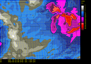
Bob Aune created a simulation of the storm that swept across the midwest on November 10, 1975 in honor of the evening the Edmund Fitzgerald disappeared into the waves of Lake Superior.
|
Storm simulation —On December 12, The Daily Cardinal, a student newspaper of the University of Wisconsin-Madison, featured Mike Richards’s article on Bob Aune’s (NOAA at SSEC) simulation of the fabled Edmund Fitzgerald storm. Aune recently recreated the storm using a computer model he helped develop for SSEC’s CIMSS. The CIMSS Regional Assimilation System (CRAS) is one of the first forecast models created to use weather satellite data. Richards, then an atmospheric science graduate student at UW-Madison, explained how the model was used to recreate this specific storm.
Finding clouds—It may seem easy, but defining what is a cloud is harder than you’d think. At this fall’s annual meeting of the American Geophysical Union, Steve Ackerman (CIMSS) presented research on behalf of a team he leads that studies how satellites can better discern cloudy versus cloud-free conditions. In the December 12 edition of the Milwaukee Journal Sentinel, reporter Patricia Townsend interviewed scientists who stressed the important role played by clouds in climate. Ackerman and others noted that, “A small change in cloud cover can overwhelm the sun’s heat effects by reflecting or trapping energy and cooling or heating up the Earth.”
Ron Seely featured weather and climate issues in the Wisconsin State Journal for Sunday, December 11. One of the three pieces in his column focused on the difficulty of defining a cloud in a straightforward fashion. More precisely, Ackerman and his co-authors noted how hard it is to find very thin cirrus clouds, which significantly influence climate. Ackerman pointed out that new satellite instruments make it easier to define the difference between cloudy and cloud-free conditions.
Fox News online carried Ker Than’s report on SSEC’s cloud research on December 8, noting the need to update a cloud classification system in use since the 19th century. Although Luke Howard’s classification has served well, it could work better if it accounted for satellite observations that reveal cloud characteristics that are invisible from the ground.
Popular polar winds—On November 29, the National Centers for Environmental Prediction incorporated the MODIS polar winds product into the Global Forecast System. NCEP is the seventh numerical weather prediction center to use the polar winds product in an operational weather forecast system. Others include: European Centre for Medium-Range Weather Forecasts (ECMWF), NASA’s Global Modeling and Assimilation Office, Japan Meteorological Agency, Canadian Meteorological Centre, Fleet Numerical Meteorology and Oceanography Center of the Naval Research Lab, and the UK Meteorology Office. Calculating the speed, height and direction of winds in the earth’s polar regions, polar satellite data fills in forecasting observational gaps and significantly extends a mid-range forecast’s scope of accuracy.
Verifying CLAVR-x abilities —The Clouds from AVHRR extended (CLAVR-x) system will function as the operational cloud detection and processing system for METOP, the forthcoming European polar orbiting weather satellite system. In preparation for operational use, data from NOAA’s Advanced Very High Resolution Radiometer (AVHRR), which are received through SSEC’s Direct Broadcast facility, were imported into CLAVR-x. High resolution (1km) data from SSEC’s Direct Broadcast will verify CLAVR-x’s high-resolution capabilities before the launch of METOP.
Arctic research in print—The October 28 edition of Science featured a paper addressing land surface change in the Arctic. Jeff Key (NOAA at SSEC) co-authored the paper titled “Role of land surface changes in Arctic summer warming.” The paper details results from an analysis showing that the change in reflectivity, called albedo, of the Arctic’s surface during the summer months contributes to overall warming trends.
Key and Xuanji Wang (CIMSS) were co-authors on “Clues to variability of Arctic minimum sea ice extent,” which appeared in the November issue of theAmerican Geophysical Union’s Geophysical Research Letters. This paper presents an analysis of several factors that have an impact on the northernmost reaches of the ice in the Arctic. The study pinpointed downwelling longwave flux anomalies as the explanation for much of the ice extent variation in this region. Anomalies in northward winds also have a significant impact in areas north of Siberia, particularly earlier in the melt season.
CIMSS researchers contribute to book—On invitation, CIMSS scientistsBormin Huang, Alok Ahuja, and Allen Huang contributed a chapter toHyperspectral Data Compression, edited by Giovanni Motta, Francesco Rizzo and James Storer, which Springer-Verlag recently published. The CIMSS researchers contributed the chapter titled “Lossless Compression of Ultraspectral Sounder Data” in support of NOAA’s GOES-R Hyperspectral Environmental Suite.
Published in JAM—The Journal of Applied Meteorology published a few papers by SSEC scientists in its December 2005 edition. Kris Bedka(CIMSS) authored “Application of Satellite-Derived Atmospheric Motion Vectors for Estimating Mesoscale Flows,” which explains results achieved through adjustments to the CIMSS Atmospheric Motion Vector processing algorithm. Operational AMV processing has data assimilation applications.Bryan Baum (NASA at SSEC) and Sarah Bedka (CIMSS) co-authored “Bulk Scattering Properties for the Remote Sensing of Ice Clouds.” Part oneof this paper discusses microphysical data and models. In particular, this portion of the paper focuses on the development of a set of models based on measurements from airborne sampling probes. Such models have the potential to serve as the basis for applications in satellite remote sensing. The second part of the paper looks at narrowband models and centers around the development of models appropriate for use by the MODIS imager.
Grants to help girls—Wisconsin has been selected to participate as a regional site for the National Girls Collaborative Project, a project that offers mini-grants to participants who collaborate to offer programming in science, technology, engineering and math (STEM), areas in which girls have been underrepresented. Coordinators in the Wisconsin Department of Public Instruction are eager to bring together educators, community-based organizations, business and industry, professional associations, and others to collaborate in grants. Rose Pertzborn, director of SSEC’s Office of Space Science Education, serves on the Champions Board, advisors in STEM areas. The National Science Foundation has awarded funding through 2006. The Wisconsin group holds its first event on January 28 in Stevens Point, WI; more can be learned from the web site.
The Indian connection —India’s President Kalam applauded an educational network that is based in a “long standing scientific cooperation between the two countries [India and the U.S.].” India’s Edusat was launched by the Indian Space Research Organisation and links U.S. educators with Indian students pursuing technical studies. On December 9, The Hindu, an Indian newspaper, reported on Kalam’s speech launching the network, and shows Rose Pertzborn, a U.S. education delegate. According to SSEC scientist Sanjay Limaye, an organizer of this collaboration, SSEC’s links with India extend back to the 1970s with a short-lived program, EDSAT, that aimed to use satellite information for educational purposes. EDSAT was managed by Delbert Smith, and conceived by Professor Verner Suomi with a counterpart in India.
Mentioned in Making Waves— The American Folklore Society awarded the Wisconsin Weather Stories project the 2005 Dorothy Howard Folklore and Education Prize, as noted in fall 2005 edition of Making Waves, the semiannual publication of the Department of Atmospheric and Oceanic Sciences. Steven Ackerman, an investigator on the project, is a professor in the department and directs CIMSS. He noted that a “project goal was to model a new kind of interaction between folklore and science, showing that both are based on careful observation of one’s environment.”
Also noted in Making Waves, Shelley Knuth, a meteorologist in SSEC’s Antarctic Meteorological Research Center and a graduate student in AOS, was awarded a scholarship from the Ruth Dickie Scholarship and Grant-in-Aid Program. The scholarship is presented by Sigma Delta Epsilon-Graduate Women in Science.
Alex Harrington, undergraduate student hourly employee with CIMSS, earned first place in the poster session of the annual meeting of the Wisconsin Space Grant Consortium (WSGC). This entitled him to present his research at the Midwest Regional Space Grant Consortium meeting in Chicago in September, where he won a $500 award. Making Waves noted that the award will be matched by the WSGC.
Bob Wollersheim eulogy —George Hesselberg’s tribute to Robert Wollersheim in the Wisconsin State Journal on December 14 included his previous association with SSEC. Wollersheim, who died of cancer in December, was responsible for reestablishing wine-making in Wisconsin. Before starting Wollersheim Winery, he worked as an electrical engineer on several early SSEC spaceflight hardware projects.