Monthly News Summary- July 2005
Preparing to launch
by Terri Gregory
 |
|
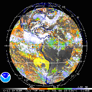
An image from the GOES-12 clouds product on July 11, 2005
|
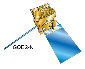
A new U.S. geostationary satellite, GOES-N, is being readied for launch this month. Scientists will be able to use its data soon after it begins to transmit thanks to researchers in SSEC’sCooperative Institute for Meteorological Satellite Studies and NOAAscientists stationed at SSEC. SSEC, CIMSS, and NOAA researchers have contributed to satellite development since GOES-3 (geostationary satellites) and TIROS satellites in the 1960s. They simulate the data, develop instrument capabilities, write algorithms, and develop products. SSEC’s Data Center, which has archived geostationary weather satellite data since 1978, assists by helping to make the data available during satellite check out.
As with GOES-12, the last GOES launched, CIMSS and NOAA (at SSEC) researchers will continue as valued members of the post-launch science test team. For the satellite currently scheduled for launch, GOES-N, SSEC’s CIMSS will produce and evaluate products made using data from the new satellite. This includes the generation of temperature and moisture retrievals, cloud top information, derived product imagery, and wind measurements. In preparation for the launch and subsequent data processing, SSEC provided NOAA’s National Environmental Satellite, Data, and Information Service (NESDIS) with six radiative transfer coefficient files. NESDIS will use these files for various computations and comparisons.
Although similar to GOES-12, GOES-N, O and P are different in that they are on a different bus, or platform, that allows navigation, registration and radiometric improvements. The new bus allows detectors to be colder, decreasing instrument noise.
In addition to developing data products, CIMSS and NOAA researchers also help train forecasters and other meteorologists to use the new data. For National Weather Service forecasters, Tim Schmit (NOAA, stationed at SSEC) developed a beta version of a GOES-N/O/P VISITview module. The module covers the similarities and differences between the current GOES series and what GOES-N and -O will offer. For example, while the GOES-N/O/P images and sounders will offer improved navigation and will also scan during eclipse periods, basic instrumentation is in general unchanged. (See also VISITview, below.)
CIMSS researchers who specialize in GOES data products are also working toward the development of greatly improved instruments and data for the GOES series starting with R to be launched in 2012.
VISITview—Several years ago, SSEC’s Tom Whittaker helped develop an online tool set for a science-based training program aimed at forecasters,VISITview. Now, participants from weather services in the United States as well as Central America and South America can attend regularly scheduled VISITview training sessions sponsored by the World Meteorological Organization. Dr. Vilma Castro of the organization’s Regional Meteorology Training Center and the Universidad de Costa Rica recently gave glowing praise of the training sessions as well as Whittaker’s involvement.
“VISIT sessions are proving to be a very powerful training tool. People learn how to use new products in real time situations, appropriate guidance is by all means of utmost importance … Participant attitude toward the sessions is changing, … they know this is an opportunity to discuss intriguing weather situations. We should congratulate ourselves for such a fantastic training activity! Thanks … Tom for your efforts with the server … Creating the habit to participate periodically and helping newcomers to overcome particular difficulties is very important.”
Seeing what they see—Through extensive software research and collaborative work with Colorado’s Forecast Systems Laboratory, CIMSS researchers can now use their Advanced Weather Interactive Processing System workstations to view the exact same satellite imagery that National Weather Service forecasters use to develop their forecasts. This is a significant step in the effort to provide the National Weather Service with improved, higher resolution satellite products.
GIFTS foreshadowed—During the spring, an informational item about GIFTS, NASA’s multi-agency Geosynchronous Imaging Fourier Transform Spectrometer, appeared on U.S. public television. In the piece, Bill Smith, an atmospheric scientist with SSEC, described the project and its possibilities. Smith formerly was chief scientist for NASA’s Langley Research Center, which produced the video.
Data down under—The Australian Broadcasting Corporation uses a year’s worth of Antarctic satellite composites in a program on extreme environments. The composites illustrate the weather in this most challenging continent.
SSEC’s Data Center supplied a special sea surface temperature image to the South Pacific Applied Geoscience Commission for a special interactive map of the southern Pacific Ocean. Click on Layer manager, and then on SST to see the credit to SSEC. In Layers manager, you can manage which image shows up.
 |
|
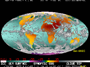
A global montage produced by the SSEC Data Center
|
SSEC’s globalmontage is used in the second edition of Professor Peter Hobbs’s (University of Washington) textbook,Atmospheric Sciences: An Introductory Survey.The authors have asked to use the image in subsequent editions.
Isabel in Japan—NHK TV, Japan’s public television station used imagery of the 2003 Hurricane Isabel in a January show . CIMSS’s Scott Bachmeier produced the loop for Japan’s Dreamvision.
Support for a NASA mission—As one of ten universities participating in a larger NASA field experiment to investigate certain aspects of tropical cyclones, UW-Madison’s Cooperative Institute of Meteorological Satellite Studies (CIMSS) fosters a team of researchers tasked with providing science support. Led by CIMSS’s Chris Velden, the team also plans to use data from the experiment to study the characteristics of a specific level of the atmosphere crucial to tropical cyclone formation.
NASA’s Tropical Cloud Systems and Processes mission will run from July 1-28, 2005 and hopes to make observations that will help answer questions about the origins and lifecycles of tropical weather systems. During this time, Velden’s research team will provide NASA with wind and wave information derived using data from weather satellites.
Using data sets from the NASA field experiment, Velden will partner with colleague John Mecikalski of the University of Alabama to diagnose the behavior of flow fields in the upper troposphere as tropical cyclones develop. The study will rely primarily on data from specialized satellite instruments as well as measurements from NASA and NOAA aircraft. This analysis will help develop tools to study and monitor conditions in the upper levels of tropical disturbances and possibly identify precursors to tropical cyclone formation.
 |
|
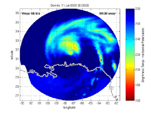
An image of Dennis … click the image to view various animations.
|
Studying tropical weather from Wisconsin—In light of Hurricane Dennis, Madison’s TV Channel 3 included information about SSEC’s tropical cyclones research on the 5:30 p.m. and 10:00 p.m. news for July 10. Intern reporter Miranda Wilkinson interviewed Howard Berger of CIMSS’s Tropical Cyclone Group. Dave Stettner demonstrated some of the computer products that the group uses to study tropical weather while in Wisconsin.
 |
|
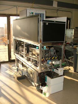
When it’s at SSEC, the Lidar lives in the penthouse. This image shows the Lidar as SSEC personnel prepare to pack it up.
|
Lidar goes north—TheArctic High Spectral Resolution Lidar (AHSRL) is on its way to the Arctic Circle for the second time in a year. Last November, the UW Lidar Group brought the AHSRL back from near Barrow, Alaska where it participated in the Department of Energy’s Mixed-Phase Arctic Cloud Experiment (M-PACE), a month-long study of Arctic clouds. Data retrieved by the AHSRL during that study will be used in climate models. Other instruments developed at SSEC, the Scanning High Resolution Interferometer Sounder and an Atmospheric Emitted Radiance Interferometer, also took part in M-PACE.
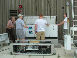 photo courtesy of Igor Razenkov
|
|
SSEC Shipping and Receiving personnel pack up the Lidar in preparation for its trip to the Arctic Circle.
|
In the eight months since the AHSRL has returned to its place under the skylight in the building’s penthouse, the Lidar group, led by Edwin Eloranta, worked to extensively revamp it for the next experiment. It worked well in Alaska to the relief of the researchers who designed and fabricated the lidar instrument to be the first fully automated UW lidar. The lidar group wanted it to operate flawlessly for its next challenge, taking measurements for NOAA’s SEARCH program. This program plans to study Arctic climate change in detail, from Eureka Base, a Canadian research outpost on Ellesmere Island. This point is the farthest north from which to track geostationary satellites. In this case, communications satellites that will be the conduit for software, diagnostics and data to and from UW–Madison’s SSEC. Read about all the innovative changes made to this complex instrument in an SSEC feature article.
DISC progress—VECO Polar Resources’ newsletter from June 27 included an article about Ice Coring and Drill Services’ (ICDS) new drill and the related scientific endeavor. The Deep Ice Sheet Coring Drill will burrow over two miles into Antarctica’s icy terrain to obtain ice core that will provide insight into atmospheric history. Looking at the history of climate change will help scientists develop better predictions as to how the climate will change due to continued human impact. Reporter Kara Nyberg included details about the drill and praise from Ken Taylor, the principal investigator for the project: “This is the first time we can conduct experiments to improve the drilling process without having to worry about damaging the ice …” Images of the drill tower and its traveling machine shop accompanied the article. The article also linked to ICDS’s Web page for the project.
ASTRO-E flies SSEC technology—In early July, a ground breaking X-ray detector that uses SSEC-developed cooling technology will launch aboard the new Japanese observatory, Astro-E. Cooling the detector allows it to detect and measure the heat generated by a single X-ray photon.
 |
|
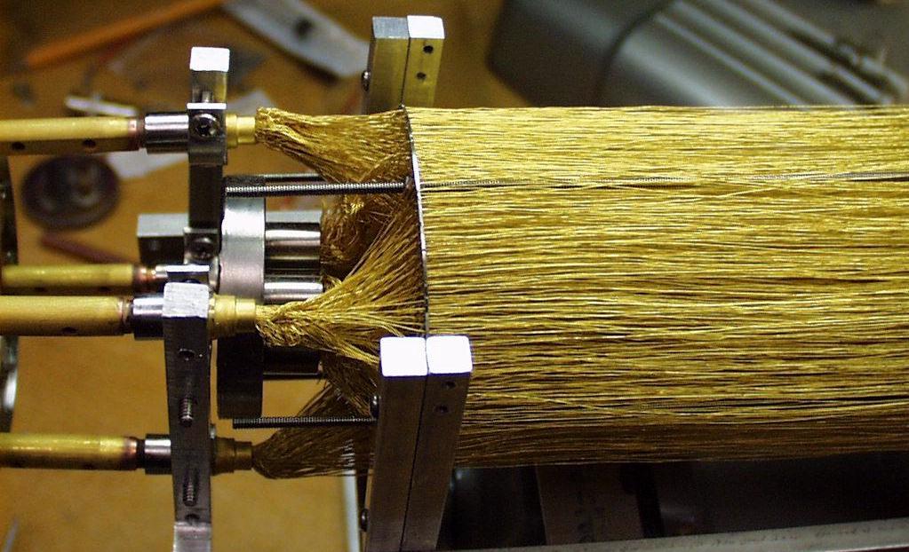
Wendricks and Jones used a perforated disk to string 1600 gold wires without letting them touch each other.
|
The observatory will collect information about X-rays to help scientists understand more about complex space phenomena like black holes, white dwarves and supernovae. The data will also provide insight into the chemicals required to sustain life. The X-ray detector created by NASA is the primary instrument on the satellite.
SSEC engineers Tony Wendricks and Dave Jones devised the cooling technology inside NASA’s instrument several years ago. They joined forces with Dan McCammon of UW–Madison’s Physics Department to create a small unit to refrigerate one of the X-ray detectors involved in the initial collaboration between the Japanese space agency and NASA for this astronomy project. Using a magnetic field and salt crystals, the unit cools the detector to temperatures cooler than space. Wendricks and Jones used a perforated disk to string 1600 gold wires without letting them touch each other. They also developed a way to grow the necessary salt crystals inside the instrument.
Life after a proposal is refused—In Wisconsin Engineer’s June edition, reporter LaShunda Prescott-Manly detailed “The life cycle of a NASA research proposal.” She looked at SSEC’s proposal for the Missing Baryon Explorer. NASA ultimately did not accept the project, but a lot of work went into the proposal. Wilt Sanders’s (SSEC) work as the principal investigator for the project received notice along with his continued enthusiasm for it even though NASA did not accept the proposal. Prescott-Manly also mentions Rosalyn Pertzborn and Sanjay Limaye’s plans for education and outreach elements, and quotes Terri Gregory about the center’s administrative policies. An image of the proposed model, an image of an instrument slated for the small explorer, and a picture of an earlier piece of space equipment in SSEC’s clean room accompany the article.
Workshop shares high spectral analysis—In early June, the fifth workshop on high spectral science was held at the UW-Madison. The workshop focused on proposed missions for the Multidisciplinary University Research Initiative on airborne, low-earth orbiting, and geostationary platforms. More than half of the attendees were from UW-Madison’s Space Science and Engineering Center (SSEC) and/or the Cooperative Institute for Meteorological Satellite Studies (CIMSS), including a few federal employees stationed at SSEC. Most of the others attended from aerospace engineering corporations, with a few from other universities and the federal government. Most attendees are collaborating with SSEC and CIMSS on data product and instrumentation development.
The workshop served as a venue for sharing research with others working with high-spectral resolution data from weather satellite instruments. CIMSS product developers and their collaborators gave in-depth talks on different research topics that involve high-spectral data, including models that incorporate cloud properties, sounding retrievals, cloud properties measured with ground and air based instruments, capabilities and new developments of radiative transfer models, convection analyzed with various sensors, cloud retrievals, and multilevel wind measurements. Also, CIMSS researchers continue to collaborate with the National Center for Atmospheric Researchto develop useful products for the Federal Aviation Agency, including those that will detect turbulence and fine volcanic ash. Both can be disastrous for airplanes flying through them.
Presentations given at this workshop are accessible through the MURI documents page. Click on Presentations (mid-page), click on workshop5. Presentations are listed in the order in which they were given. Good summary highlights can be found in muri_01_feltz_summary-1.ppt. Excellent overviews are found in muri_24 through muri_29, from historical and product description perspectives. Maria Vasys and Wayne Feltzorganized the workshop for CIMSS under the leadership of Allen Huang.
Representing CliC—From June 1-2, Jeff Key (NOAA with SSEC) attended the first World Climate Research Programme Observations and Assimilation Panel held in New York City. Key represented the programme’s Climate and Cryosphere (CliC) project. Representatives from all of the major projects under the programme attended. NASA’s Goddard Institute for Space Studies (GISS) hosted the panel.
CIMSS Board of Directors—The CIMSS Board of Directors held their annual meeting on June 22. NESDIS’s Eric Bayler, NASA’s Jack Kaye, and UW’s Dean of the Graduate School Martin Cadwaller gave presentations. CIMSS Director Steve Ackerman gave the “State of CIMSS” address to both the board and the general public. His talk highlighted science activities of the past year and gave insight into future work, while also providing a framework within which the research fits.
Presentations and Publications
Space meeting in India—Rosalyn Pertzborn, director of SSEC’s Office of Space Science Education , and SSEC senior scientist Sanjay Limayespoke at the Astronautical Society of India’s Regional Conference 2005 in Bangalore. The conference combined both planetary exploration and space law and focused on “Bringing Space Benefits to the Asian Region.”. During the afternoon session on “Space Science and Education,” Pertzborn spoke on training the next generation of scientists. News of the IAA-IISL Regional Conference 2005 noted that she described “the scope and breadth of programs affiliated with NASA’s solar system missions.” In the afternoon session devoted to planetary sciences, Limaye presented “New Frontiers in Solar System Exploration: The Community Input to the NASA Decadal Survey (2003-2013)” and described the political and practical process by which NASA selects solar system missions. The process includes scientists’ input and National Academy of Science recommendations. Budgetary and other resources and community interest “determine how much of the community vision is realized … .”
BAMS inclusion—A summary of Howard Berger’s (CIMSS) AMS satellite conference paper, “Superobbing for Atmospheric Motion Vectors,” appeared in the conference summaries of the January 2005 Bulletin of the American Meteorological Society. The paper was presented at the satellite conference at the American Meterology Society annual conference. Conference summaries only include a subset of the hundreds of papers presented at the annual AMS meeting.
A paper by Andrew Heidinger and Michael Pavolonis titled, “Global Daytime Distribution of Overlapping Cirrus Cloud from NOAA’s Advanced Very High Resolution Radiometer” has been accepted for publication in theJournal of Climate. This work applies a recently developed algorithm to derive one of the first global depictions of the occurrence of multi-layer clouds from a satellite. The technique has been expanded for application to data from polar orbiting and geostationary satellites currently being prepared for launch. A more complete climatology that includes the occurrence of multi-layer cloud is being developed under the AVHRR Pathfinder Atmospheres Extended (PATMOS-x) project.
Outreach in India—SSEC’s Sanjay Limaye continues to receive attention in his position as the center’s ambassador to India. India’s Jagranand the Times News Network both included positive references to the daylong workshop for teachers that Limaye organized at IIT Kanpur on November 18, 2004.