Monthly News Summary – September 2004
Hurricanes wreak havoc in the Atlantic
This issue of SSEC In the News covers news and research results primarily from August and September 2004. Use images freely with credit to the Space Science and Engineering Center, University of Wisconsin–Madison, but please notify SSEC’s Public Information Officer.
Understanding tropical storm activity with CIMSS’ Tropical Cyclone Research Team
by Jen O’Leary
In the Atlantic Ocean, the summer months officially mean hurricane season. Residents in areas along the coastline find themselves facing flooding and destructive winds. As nature continues to wreak havoc, Christopher Velden and the CIMSS Tropical Cyclone Research Team find themselves inundated in a different way.
 |
|
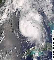
MODIS image taken August 13 of Hurricane Charley
|
While Florida continues to cope with the reality of tropical cyclones, namely Hurricanes Charley and Frances with Ivan trailing not far behind, Velden and his team of atmospheric scientists analyze the continuous stream of data. From their perch in the Space Science and Engineering Center on the UW-Madison campus, the Tropical Cyclone Research Team watched as Hurricane Charley developed off the coast of Africa and then as it intensified right before it crashed into the Florida coast.
Under Velden’s leadership, the Tropical Cyclone Research Team develops technology to help meteorologists use satellite information to better understand the characteristics of tropical cyclones. Their work will allow more accurate forecasts and, consequently, more effective warnings for the public.
The media have criticized hurricane forecasters for failing to predict this intensification. However, as Velden points out in a Wisconsin State Journal article from August 18, the changes that generally cause storms to intensify are often subtle and difficult to forecast. He also mentions that experts predicted Charley’s landfall four days prior to its occurrence, which is earlier than it would have been even a few years ago. Forecasting technology has improved immensely and continues to do so.
 |
|
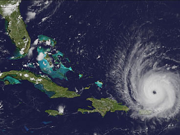
An image of Frances produced by Rick Kohrs
|
Through their research, Velden and his team have contributed to the advancement of forecasting technology. For example, in 1998, the Tropical Cyclone Research Team came up with a computer-based algorithm as a way to remove subjectivity from the Dvorak Techniqueused to determine the strength and potential path of the storm. It uses digital infrared information to objectively create a profile for a storm. The meteorologists at the National Hurricane Center in Miami, among others, utilize this algorithm.
In order to understand the tropical storm activity this year and the tools used to look at it, many media outlets have sought out the expertise of Velden and his team of hurricane specialists.
Conversations with the Tropical Cyclone Experts
Herald-ing the storms – The September 13 edition of the UW-Madison student paper The Badger Herald ran an article featuring Christopher Velden and Robert Wacker, a PhD candidate in Velden’s Tropical Cyclone Research Team. Velden and Wacker discussed the importance of CIMSS products and imagery the prediction and subsequent analysis of the hurricanes this summer.
On the evening news – Christopher Velden and Rick Kohrs imparted their tropical cyclone wisdom to the masses on a September 2 FOX 47 news report. Velden provided a researcher’s point of view and Kohrs a product developer’s. They had a chance to discuss their research and products as well as show off some of SSEC’s imagery.
CIMSS Tropical Cyclone page popular with Web surfers–As one might imagine in light of the activity of this year’s hurricane season, curious storm trackers have found their ways to the Tropical Cyclone Research team’s webpage in droves. By mid-September and the arrival of Hurricane Ivan, the page received over 25 million hits and expected about 10-15 million more in the following few days. Goar J. Díaz Acosta of Cuba has used the site to follow Hurricane Ivan at the recommendation for his daughter, Désirée Díaz, a teaching assistant at UW-Madison. ” I want to congratulate you, because the information is very complete (more complete than in other places) and very well organized. […] Thank you for the work that you make,” Mr. Díaz said in a Sept 14 e-mail. While hurricanes pound the Atlantic coastline, Internet users seek out further details to supplement the media coverage.What better place to look than a webpage made by atmospheric scientists?
 |
|
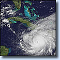
Ivan animation
|
Satellite Animation – UW- Madison’s Communications Office to publicized SSEC’s new satellite animation tool through a September 2 news release. Developed by programmer Rick Kohrs, the tool provides close to real-time movies of tropical cyclones. It updates every half hour using satellite information.Christopher Velden says the new tool will remain online throughout the hurricane season.
In the wake of Charley – Looking at winds – Jim Kossin with CIMSS provided insight in to mesovortices in the St. Petersburg Times. On August 20, the St. Petersburg Times put out a story looking at Hurricane Charley’s winds. Kossin discussed how winds in a mesovortex are selective in what they destroy.
Analyzing Charley – On August 18, the Wisconsin State Journal printed an article about SSEC’s involvement in forecasting and, subsequently, attempting to understand Hurricane Charley.Christopher Velden was called upon to discuss the technology used to forecast hurricanes.
Improving, but not perfect – The Washington Post quoted Christopher Velden in an article about tracking tropical storms. Velden used an analogy to illustrate how unpredictable nature can be: “You can think of a hurricane as a piece of wood in a river. The hurricane is embedded in a steering current, which controls its direction, like a current in a river controls which way a piece of wood goes. Small eddies in the current can change the course.” He also discussed how, currently, satellites mostly gather infrared data while newer tools will tap into the microwave portion of the light spectrum, allowing scientists to look at the structure underneath a storm.
Wisconsin worries – In an August 14 Wisconsin State Journal article about how the Floridian hurricanes affect Madison residents, Christopher Velden talked about how the Tropical Cyclone Research Team watches developing storms. The article also mentioned the computer-based algorithmdeveloped at SSEC in order to objectively determine a storm’s strength and potential path.
Bracing for a double whammy – NewScientist.com called on the knowledge of Derrick Herndon, one of the experts in the Tropical Cyclone Research Team. In an article printed on August 13 about Hurricane Charley and tropical storm Bonnie, he discussed the threat of storm surge and tornadoes that often correlate with hurricanes. He also pointed out the “worst-case-scenario” geometry of the hurricane’s projected path.
Doing what they do best – The Tropical Prediction Center in Miami acknowledge the usefulness of CIMSS products in forecasting this summer’s tropical activity. Both CIMSS imagery and products proved instrumental in the analysis prior to and following the storms.
Imagery Galore
 |
|
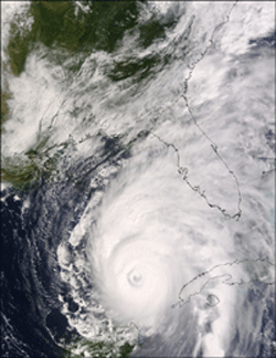
MODIS image of Hurricane Ivan
|
As the media attempt to cover the tropical activity raging around the Atlantic, various organizations have used images from SSEC. On their Web site, NASA used an image of Hurricane Charley procured by SSEC from the MODIS sensor on NASA’s Terra satellite. The true-color image showed Charley rapidly intensifying approximately 90 minutes before it reached category 4 status. They also used a MODIS image of Hurricane Ivan from September 14 as it approached the Gulf of Mexico. Liam Gumleyproduced this image.
Across the pond in London, TV Channel 4 used Rick Kohrs’ Hurricane Ivan animation on their evening news for September 10.
Yahoo News used a McIDAS image of Hurricane Frances in a September 1 posting.
Accompanying an article about work done by the Tropical Cyclone Research Team, the Wisconsin State Journalused an image of tropical storm Bonnie sitting over the Gulf of Mexico while Hurricane Charley waits in the wings. This image is also one produced by SSEC.
CNN.com also used a UW-credited image of Hurricane Charley as it approaches the Florida coast in an article from August 16.