Monthly News Summary – July 2004
Where There’s Fire …
In late June, Wisconsin sky watchers noticed “milky” skies, despite a lack of clouds and humidity. An educated guess would be that smoke has flowed in from fires somewhere far away. Satellite imagery and ameteorological analysis by researcher Scott Bachmeier confirms it.
On June 25, numerous large fires had been burning in Alaska and western Canada for a week. A big ridge of high pressure kept the weather from changing, and temperatures were in the 90s, setting daily high records. Towns of Petersburg, Gustavus, and Hoonah all set records for the highest temperature on that day. Juneau Airport, with 8 consecutive days of temperatures in the 80s, set a record for consecutive days of 80 degrees or higher. The old record was for 4 days set in 1951. These 8 days also set a new record for the number of days in a summer of 80 degrees or higher. Juneau’s old record of 7 days also was set in 1951.
The smoke first became obvious in satellite images taken late on June 19. Animated imagery from 3 satellites shows smoke pouring from fires in Alaska and Yukon Territory on June 19 and 20.
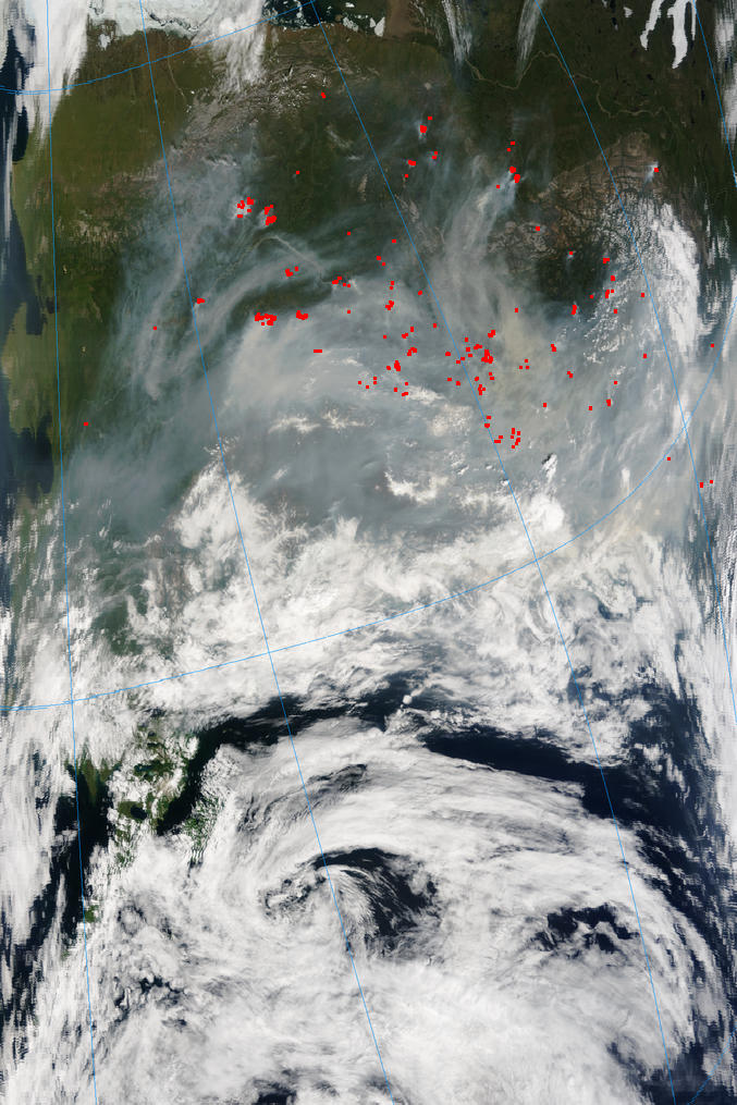 |
Fires burning across Alaska and Canada’s Yukon Territory are highlighted in this image taken by the MODIS instrument on NASA’s Terra earth system satellite on June 28. |
The IDEA Web site, now hosted at SSEC’s Cooperative Institute for Meteorological Satellite Studies (CIMSS), discusses the fires and their effect on air quality across the northern United Sates. The forecast discussion for July 1 noted:
Most of the smoke is now remaining closer to the fire source regions, causing air quality problems in central interior Alaska (Fairbanks web camera). Long-range transport had previously carried some of the smoke over the Great Lakes and the northeastern U.S., leading to moderate to high values of MODIS Aerosol Optical Depth seen across parts of southern New England, the mid-Atlantic states, and the adjacent offshore waters. The majority of trajectories originating over the Northeast show a cyclonic eastward to northeastward transport of this aerosol during the next 48 hours, influenced by the shortwave trough progressing eastward across Ontario and Quebec. Generally high trajectory pressures suggest some potential impact on boundary layer air quality across the northeastern U.S. (and extreme southeastern Canada) during the forecast period. Trajectories originating farther west over the Ohio Valley region show a slower northward transport across the Upper Midwest and Great Lakes regions (and eventually into southern Canada), with some likely influence on boundary layer air quality over those areas as well. Aerosol loading may be reduced somewhat by scattered periods of convective precipitation along portions of the transport pathways during the forecast period. [The last sentence means that the smoke may wash out of the air when it rains.]
IDEA, a project started at NASA’s Langley Research Center, stands for Infusing satellite Data into Environmental Applications and is a collaboration of NASA, NOAA, the EPA, and CIMSS.
NOAA’s Hazard Mapping System combines algorithms (computer techniques) using data from a number of satellites to show large fires and smoke plumes. It has been showing “impressive fire counts and smoke plumes,” according to CIMSS’ Scott Bachmeier.
The UW Lidar program, led by atmospheric scientist Ed Eloranta, develops instruments particularly adept at sensing haze, including smoke. The image shown here was produced with the Arctic High Spectral Resolution Lidar, being tested on the top floor of the Atmospheric, Oceanic and Space Sciences Building, looking up through a skylight to collect data.
The dominant feature in this image is caused by forest fire smoke. It appears between altitudes of 3 and 12 km. The altitude distribution of the smoke reflects both conditions at the source (i.e., the heat of the fire and the atmospheric temperature profile) and atmospheric vertical motion encountered while the smoke was transported between the fire and Madison. It has also been suggested that smoke plumes may be lofted due to vertical motions caused by solar heating of smoke. The importance of this effect depends on how much sunlight is absorbed by the smoke.
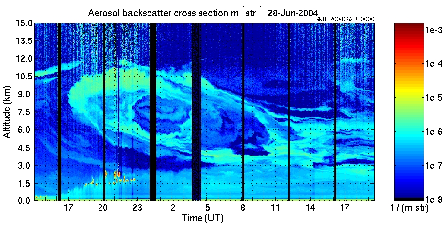 |
The image covers the period between 14:00 UTC on June 28 to 19:30 UTC on June 29, at altitudes between 0 an 15 km. Black vertical stripes occur every 4 hours when the lidar interrupts data collection to calibrate itself. |
The convective boundary layer grows from ~500 m to 2.8 km between 16 and 20 UT on the 28th. Fair weather cumulus appears in the upper part of the convective boundary layer between 18:30 and 23:00 UT on the 28th (red and yellow spots). This mixed layer persists though the rest of the period with a maximum altitude of about 3 km. Some of the smoke appears to have been mixed into this layer.
The Arctic HSRL is being readied for a trip to Barrow, Alaska, in the Arctic Circle, where it will collect data on climate change.
Data and Imagery
The new CIMSS Web page, “Thank you, GOES-8, … ,”is devoted to the accomplishments of recently decommissioned Geostationary Operational Environmental Satellite (GOES)-8. The page links to sample GOES-8 imagery and products for a number of disciplines. The accomplishments, of course, are those of NOAA scientists and others, particularly cooperative institutes located throughout the United States and in Puerto Rico. The page also gives a bibliography of more than 100 journal articles and a page of links. The page was produced by Kris Karnauskas, an undergraduate student researcher since graduated from UW–Madison’s Department of Atmospheric and Oceanic Sciences.
Engineering Feats
IceCube, the neutrino telescope project managed at UW–Madison, is featured in the first Antarctic Sun Midwinter Special issue. The newspaper is usually published only in the southern summer; this year, because science and other work continues year round, they decided to publish at least once during the winter. The coverage of IceCube is detailed and notes that AMANDA, small IceCube precursor, was proposed to be enlarged for more likely results. When the article was published (June 21), wooden stakes marked out locations for 80 new holes that will grow around AMANDA like “rings on a tree, extending to within a half kilometer form [South Pole] station. A large part of the article is devoted to drilling via the Enhanced Hot Water Drill, newly designed by SSEC’s Ice Coring and Drilling Services. It’s a tricky business using hot water to drill holes in ice. Though it sounds simple, engineers need to make sure “that hole is deep enough, straight enough, and melts fast enough.” The new drill is twice as big and twice as hot as the drill used for AMANDA, which was already the biggest in the world. While the hose reel, weighing nearly 50 metric tons, arrived at the South Pole in January, all supporting equipment including 2.9 km of hose will go to the Pole later this year.
Field Experiments and Meetings
The 7th International Winds Workshop, sponsored by the World Meteorologicial Organization (WMO), was held in Helsinki, Finland during the week of June 14. The workshop was attended by 50 participants from the international satellite and data assimilation communities. Chris Velden (Cooperative Institute for Meteorological Satellite Studies, CIMSS) was a co-organizer, with Dave Santek (CIMSS), Jeff Key (NESDIS, at SSEC) Jaime Daniels (NESDIS) and Paul Menzel (NESDIS, at SSEC) also participating. Velden gave a presentation on the potential for deriving wind vectors from hyperspectral satellite data. Key and Santek both talked about using polar winds from MODIS data.. Key also presented a paper on the prospects of deriving thermal wind measurements over the polar regions for climate reanalyses. Daniels gave an update on NESDIS winds processing. Menzel talked about the performance of vector height assignment algorithms. A highlight of the workshop was the demonstrated impact of the MODIS polar winds on global numerical forecast systems. Several presentations were given by the data assimilation participants, stressing the positive model forecast impacts being realized by assimilating MODIS polar winds.
The India – United States Conference On Space Science, Applications and Commerce was held in Mumbai, India in late June to explore possibilities for cooperation in those areas. Sanjay Limaye, SSEC planetary scientist, and Paul Menzel, NOAA chief scientist stationed at SSEC, spoke Wednesday, June 23, on Current and Future Collaboration Activities between India and U.S. in the area of Earth Observation Science, Technology and Applications in Meteorology and Ocean Sciences.
Weather Research
New Web Content CIMSS Web pages for the Hyperspectral Environmental Suite (HES) have been updated to include simulations of the HES, the next-generation GOES sounding instrument, with data from the Atmospheric Infrared Sounder (AIRS) and the National Polar-orbiting Operational Environmental Satellite System Airborne Sounder Testbed-Interferometer (NAST-I). CIMSS researcher Chian-Yi Liu also includes trade-off studies, Advanced Baseline Imager (ABI) and HES synergism, HES temporal resolution, and more in the page, which is an offshoot of the CIMSS GOES product development pages. Links in a left-side panel lead to more information on each topic summarized in the main page.
CIMSS has also begun to host a Web site for the Infusing satellite Data into Environmental Applications (IDEA) project, which showcases the Aerosol Optical Depth (AOD) product derived from the polar orbiting Moderate resolution Imaging Spectroradiometer (MODIS) instrument, and intended to be a tool for the U.S. air quality forecasting community. Scott Bachmeier prepares daily forecast discussions.
Preparing Weather Satellites—To prepare for its eventual operational use, the Geostationary Operational Environmental Satellite (GOES) -11 was brought out of storage for most of June. While it was “active,” the data known as GOES VARiable (GVAR) were archived by SSEC’s Data Center. Transmission of both Imager and Sounder radiance information from GOES-11 affords the opportunity to generate derived product information and compare their quality to products based on GOES-12 radiance information. This exercise not only ensures operational readiness, but makes it possible to uncover potential problems much before an instrument needs to be used. Also, archiving these unique data enables understanding of how on-orbit storage has affected instrument performance. Examples of both Imager and Sounder radiance comparisons and some derived products are on the CIMSS Web site. Researchers involved in the effort are Tim Schmit (NOAA, at SSEC), Mat Gunshor (CIMSS), Scott Bachmeier (CIMSS), Gary Wade (NOAA, at SSEC), Tony Schreiner (CIMSS), and Jim Nelson (CIMSS). Dee Wade manages SSEC’s Data Center.
Papers
“Synergistic use of MODIS and AIRS in a variational retrieval of cloud parameters” has been accepted for publication in the Journal of Applied Meteorology. This cloud retrieval study is relevant to ABI and HES systems on GOES-R (in the next series of geostationary weather satellites). Co-authors are Jun Li (SSEC’s CIMSS), W. Paul. Menzel (NOAA, at SSEC), Fengying Sun (NOAA), Timothy J. Schmit (NOAA/NESDIS/ASPB, at SSEC), James J. Gurka (CIMSS, stationed near Washington, D.C.), and Elisabeth Weisz (CIMSS).
“Retrieval of ice cloud optical thickness from Atmospheric Infrared Sounder (AIRS) measurements” has been accepted for publication in the IEEE Transactions on Geoscience and Remote Sensing. This study is relevant to the Cross-track Infrared Sounder (CrIS) on the National Polar-orbiting Operational Environmental Satellite System (NPOESS) and the Hyperspectral Environmental Suite (HES) on GOES-R. Co-authors are Heli Wei and Ping Yang (Texas A&M University); Jun Li, Bryan A. Baum, Hung-Lung Huang (CIMSS); and Steven Platnick and Yong X. Hu (NASA).
Education, Outreach, Service
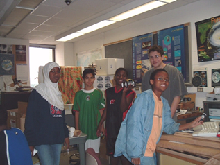
Training PEOPLE, by Alexis Karnauskas—The Space Science and Engineering Center along with the UW Space Place and the Wisconsin Department of Transportation sponsored a learning opportunity in June for 13 middle school and high school students in the UW Madison PEOPLE (Pre-college Enrichment Opportunity Program for Learning Excellence) program. The students spent three weeks learning in-depth about aviation, rocketry, and space exploration. During aviation week they delved into everything related to airplanes—types of airplanes, their parts and how they work. The week culminated with a trip to Wisconsin Aviation at Dane County Airport where the students took off on Young Eagle flights. Pilots Bill Wambach and Tom Thomas volunteered their time taking the PEOPLE students on half-hour flights over the Madison area. During rocketry week they learned about Newton’s Laws and rocket propulsion by making their own model rockets. The final week the students examined space exploration and the solar system. They built replicas of planets, rockets and mars Lego motorized terrain rovers.
PEOPLE is a year-round learning program for minority and underprivileged middle school and high school students that are interested in pursuing higher education. The aviation, rocketry and space exploration workshop is one of the many programs that PEOPLE offered this summer, with the goal of increasing enrollment and graduation of ethnic minorities and low-income students at UW Madison and other institutions of higher education. The Madison Times from the week of June 25, 2004 featured an article on the PEOPLE workshop, which mentions SSEC’s involvement in the program.
NASA’s Summer High School Apprenticeship Research Program, SHARP, has brought about 40 students to the University of Wisconsin–Madison this summer, most of them to the Medical School. The students come from all over the United States and compete to participate. SSEC is pleased to host Julie Henderson from Albuquerque, New Mexico, who will work with tropical cyclones scientist Jim Kossin. Henderson, who began her project in June, is correlating satellite infrared imagery from GOES with measurements of hurricane intensity.
Honors
The journal, Advances in Geosciences, has asked Rose Pertzborn, director of SSEC’s Office of Space Science Education, to serve as Guest Editor for a special Education section. The journal is based in Katlenburg-Lindau, Germany.
The Kokomo, Indiana, Perspective featured the 22nd Annual Founders Day of its local Wisconsin Alumni club on April 21. Columnist Pat DiSalvo highlighted Sanjay Limaye’s guest speech, on Mars exploration. Limaye noted that, “Mars has weather. It has frost that melts. …” He also explained that from hints in meteorites it is believed that “life existed on Mars about four billion years ago.”
In the Wings
UW Day—SSEC and other groups in UW–Madison’s Atmospheric, Oceanic and Space Sciences Building are taking part in this year’s UW Day at the Wisconsin State Fair. On August 6 this year, the University of Wisconsin brings representatives from campuses around the state with displays to engage the crowd. SSEC will bring its AERIbago and measure what’s in the air directly above State Fair Park. Scientists will be on hand to explain the profiles obtained by the Atmospheric Emitted Radiance Interferometer, housed in a converted Winnebago. Also participating are SSEC’s Antarctic Meteorological Research Center [link] and the Environmental Remote Sensing Center [link] in the Nelson Institute for Environmental Studies, and the Weather Guys who are Jonathan Martin (chair of the Department of Atmospheric and Oceanic Sciences) and Steven Ackerman (director of the Cooperative Institute for Meteorological Satellite Studies). Both “Guys” are atmospheric science professors who appear monthly on Larry Meiller’s WHA Radio program. Many other UW–Madison groups will be represented on the State Fair Mall on August 6, including Biotechnology and Genetics. The Fair runs from August 5–15.
Also of Note
Now you can find out how severe the impact of any asteroid will be—on you. Science News (May 22) reports on a program that “calculates the energy of the impact and the extent of the hole it will gouge” along with many other factors, including the strength of its shock wave. Robert Marcus, an undergrad at the University of Arizona in Tucson developed the program with astronomers H.Jay Melosh and Gareth Collins. Their program uses a 1977 government handbook on nuclear weapons and data from California earthquakes. Better than reading about it, you can calculate yourself. The program has been on the Websince April.
Listed in the Books edition of the Bulletin of the American Meteorological Society (May 2004) is Wisconsin’s Weather and Climate. Authors are Joseph Moran and Edward Hopkins; Hopkins is Wisconsin’s assistant state climatologist and teaches in UW–Madison’s Department of Atmospheric and Oceanic Sciences. The book is published by University of Wisconsin Press.