New Retrieval Technique Yields More Useful Satellite Data
The disastrous tornado strike in Moore, Oklahoma, was a grim reminder of a well-known truth: we can’t prevent tornadoes; we can only work for earlier and more accurate prediction of their formation and approach.
Ground observations and radar have long been our standard detection and warning systems, but satellites, flying high in orbit, equipped with infrared instruments, are becoming the new cutting edge in storm detection.
The challenge now for scientists is to find a way to use the wealth of data available on newer satellites. The sheer amount of detailed data makes computation challenging, particularly in an operational, or real-time, environment.
Dr. Elisabeth Weisz, Associate Scientist at SSEC, and her colleagues Dr. Nadia Smith and Dr. William L. Smith Sr., are developing new techniques to help scientists work with the increased flow of data.
“We had to find a better way to access the existing information,” Weisz says. “You need an algorithm which automatically accesses the information.”
Previously, weather satellites could collect data from 15 – 20 different channels, or wavelengths, in the infrared spectrum. Each of these channels is sensitive to water vapor and temperature at different heights in the atmosphere. Using this data researchers can create a vertical profile of conditions in the atmosphere.
In the past ten years a series of new generation hyperspectral sounding instruments have been launched that can collect several thousand channels of information, providing a far more detailed picture of what is happening in the atmosphere. To date, four polar-orbiting satellites carry hyperspectral sounders: AIRS (Atmospheric Infrared Sounder) on the Aqua satellite, IASI (Infrared Atmospheric Sounding Interferometer) on Metop-A and Metop-B, and CrIS (Cross-Track Infrared Sounder) on Suomi-NPP.
“We needed a retrieval software package which works on all four available hyperspectral sounders,” Weisz says. “We have developed an algorithm that yields accurate results in real-time situations, recording temperature readings, atmospheric gas compositions, and cloud-top measurements for any of the hyperspectral sounder instruments.”
These measurements provide accurate sources of information not just for scientists studying the intricacies of atmospheric dynamics, but also to use in more timely weather forecasting.
“We want this software to be useful for forecasters as well as researchers,” Weisz says. “It had to be useful and user-friendly for local implications and global implications. It should benefit data assimilation and forecasting applications. What our software does is very new. We want them to look at our product in addition to what they already use and to use these retrievals in their forecasts.”
The new hyperspectral software works best in conjunction with current high-spatial instruments such as the Suomi-NPP Visible Infrared Imaging Radiometer Suite (VIIRS). The VIIRS provides high-resolution imagery over a large area, revealing details as small as 1 km wide. The hyperspectral sounder has a much coarser spatial resolution (14 km), but can resolve several thousand different infrared spectra and provides objective quantitative information of the three-dimensional atmosphere. Combining the two data types results in a very detailed view of atmospheric conditions. Figure 1 shows a VIIRS image together with different sounding retrieval products from CrIS to depict a low-pressure system over the Gulf of Alaska.
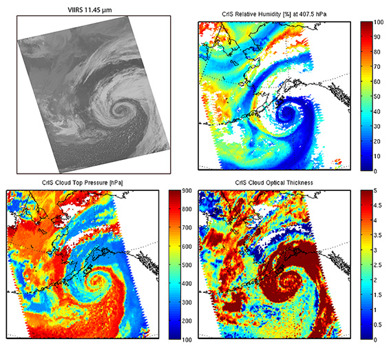
Figure 1. VIIRS 11.45 µm (I5) band, CrIS retrievals of relative humidity (at 400 hPa), cloud top pressure, and cloud optical thickness for a low-pressure system over the Gulf of Alaska on 26 September 2012.
The Suomi-NPP VIIRS IR band image shows great spatial detail of cloud features of the rapidly intensifying cyclone, differentiating between optically thick and thin clouds; CrIS, on the other hand, although at lower spatial resolution, retrieves the same spatial features but now adds quantitative value of the geophysical parameters (e.g., cloud altitude).
“Today, everyone in the forecast community is looking at the VIIRS visual wavelength image,” explains Dr. Nadia Smith, SSEC Researcher, “especially with its day-night band. It is really useful. With our product, we can enhance the VIIRS data imagery. We are not working to replace the high-spatial instruments, but to complement them with high spectral information. We make the high spectral data work in connection with the high vertical resolution.”
In addition to complementing imager data, atmospheric retrievals from different sounders on consecutive orbits enable the study of atmospheric cloud and moisture motion, as well as the detection of thermodynamic stability changes that may occur before severe weather events. For example, Figure 2 shows the rapid atmospheric destabilization (illustrated by an increase in the total totals index, which measures thunderstorm potential and severity) that took place during the day on 20 May 2013, just before the devastating tornado struck Moore, OK.
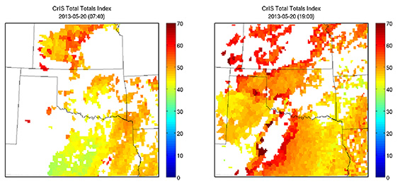
Figure 2. IASI (left) and CrIS (right) total totals index (computed for clear skies) at 16:51 UTC and 19:00 UTC, respectively, on 20 May 2013. Large total totals index values indicate highly unstable air.
To encourage the operational use of hyperspectral retrieval data in National Weather Service (NWS) forecasting offices, Weisz and her colleagues currently prepare retrieval products from AIRS, IASI and CRIS, as well as the time differences between consecutive overpasses, for near real-time viewing and analysis through the Advanced Weather Interactive Processing System (AWIPS).
The hyperspectral retrieval software has been released as part of the CIMSS CSPP (Community Satellite Processing Package) and is freely available.
“The NWS forecasters are used to looking at their data using the AWIPS system,” Weisz says. “Our software converts the products we create from the hyperspectral data to the AWIPS format. Forecasters can use the results to create images that they can superimpose on the VIIRS visuals. The more tools we can provide to the forecasters and researchers, the better we can understand and predict these severe weather events.”